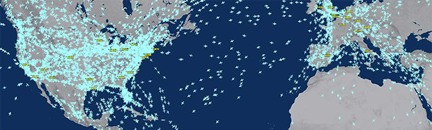
For the sufficiently geeky aviation nerd there’s FlightAware, a website that tracks just about every airliner and most private planes currently in flight. The folks at FlightAware compile all the information with the help of a few thousand volunteers around the world that have a bit of hardware to listen to ADS-B transmissions and relay them to the FlightAware servers. Now you can do this with a Raspberry Pi, and as a nice little bonus FlightAware is giving away free enterprise accounts to anyone who does.
Listening in on ADS-B transponders is something Raspberry Pis have been doing for a while, but doing anything useful with the altitude, speed, heading, and registry numbers of various planes flying overhead is pretty much FlightAware’s only reason for existing, and the reason they’ve developed an easy to use software package for the Pi.
Setting everything up requires getting dump1090 running on the Pi, the only hardware required being an RTL-SDR USB TV tuner, a GPS module, and an antenna for 1090 MHz. From there, just send all the data to FlightAware and you get a free enterprise account with them. Not a bad deal for the aviation nerds out there.


An enterprise account costs $89/mo. If you have a need for one already the total hardware cost would be paid off within 2-3 months.
The rtlsdr is only $10-$20, a GPS is $20-$30, and an antenna is a few dollars. Even if you don’t already have a raspberry pi or computer to use it’s still going to be less than $89.
True. I’d been factoring in an antenna mast and weatherproof enclosure for the RPI into this equation, but either way this is a very good deal if you need data from beyond local observation range.
A truly ingenious cheapskate would probably be able to grab this data via API, turn it into the sort of data dump1090 produces, and feed it back to FlightAware as locally-sourced content: This wouldn’t even need any special hardware :)
That map scares the hell out of me. It shows the extent of weather modification by so many aircraft. Till this week we haven’t had any summer. The jet stream is not where it is supposed to be. 30 years ago the concern was over less sunshine on crops under the skies of Indiana and Illinois, the heaviest flight path in the US. Now we are starting to reexamine the whole mess we have made. 9-11 and the next 3 days was the only experiment done so far on the effects of aircraft on the weather. There is an effect!
How’s that tinfoil working for you?
To me the biggest, ‘ah ha’ moment is when I realized that pilots would have to be in command of the chemtrail system, but not be aware of it. That’s when it hit me. What switch in the cockpit do pilots leave on in flight and not think twice about? The ‘no smoking’ light. It was so obvious. Even the pilots don’t know they’re spraying chemicals. The FAA and illuminati have silently installed the equipment to pump chemtrails into the atmosphere without any of the tens of thousands of pilots being aware, simply by tying it in to the no smoking light, It’s genius.
slash ess for sarcasm tag
FYI, in all modern airliners, the no-smoking switches are all enabled to be on all the time. The seat belt light is the one they have control over but even that can be automated according to flight plan. So the pilots can’t turn it off, even if they wanted to :) Full Disclosure: I work on Commercial (747/MD-11)Full Flight Simulators for a living.
There is a way to reply to these types of comments, but directly throwing insults doesn’t help anyone.
Well his Tinfoil hat (actually it’s aluminum foil, they haven’t used tinfoil for years) may not be cutting off the oxygen to his brain, seems that contrails (not chemtrails) may have an effect of weather, e.g.
http://en.wikipedia.org/wiki/Contrail#September_11.2C_2001_climate_impact_study
Here, have a bukkit of troll feed.
Each pixel of each blob on that map covers hundreds of square miles. The average area of the shadow cast by the plane at the center of each blob (remember: this includes small commuter flights) is on the order of hundreds of square feet.
The doctors need to adjust your dosage, and restrict your Internet access.
He’s not exactly wrong, aircraft do alter weather patterns. Another poster put up the link, 9/11 gave a rare glimpse as to how much.
Volcanoes are good for this sort of thing as well as traffic gets re-routed, though not as as good as 9/11 due to the whole ‘volcano spewing out heaps of ash & stuff’ thing going on.
Flightradar24 offer a similar deal and you dont need a GPS module…
Instead of the community giving this data to a company to put behind an expensive paywall, why not send it an open access DB like Open Street Map?
Caveats aside: Realtime data, fewer people etc.
1. Because no one has created a “free” service.
2. The free parts of the service are really very good and good enough probably for most people.
Simple truth is nothing is really free someone has to pay for the server space, admin time, and developer time. Even if the person paying is the developer and admin themselves.
There is one. Try http://www.adsbexchange.com.
Funny, the GPS requirement appears no where on the linked PiAware article on the FlightAware site. I don’t believe this is required any more. Surely running some regular NTP updater will keep slew lower enough.
To answer my own question, GPS is used to get accurate nano timestamps. Having build my ADS-B setup since reading this article, I’ve found that most targets only return a heading, altitude, squak and ICAO hex code. You don’t usually get Lat/Lng. So, you’ve got to triangulate the output from a bunch of sensors using time of flight analysis. GPS is the only way (short of a Raspberry Pi atomic clock module) to get this accuracy for that analysis.
Sadly, this also means that unless you’ve built your own sensor network, you don’t have enough pieces of the puzzle to get useful data from your contribution to FlightRadar24 or FlightAware, but said organizations do.
does that also work with helicopters? that is the main problem in my area…
HELLO does that also work with helicopters? ???????? PLEASE ANSWER
Yes providing they have a transmitter.
The simple truth is that no one has to pay for server space, admin time and developer time. Thanks for the post on aviation services. Your post contains lots of valuable information.