Knowing Your Place: The Implications Of GPS Spoofing And Jamming

Artificial satellites have transformed the world in many ways, not only in terms of relaying communication and for observing the planet in ways previously inconceivable, but also to enable incredibly accurate navigation. A so-called global navigation satellite system (GNSS), or satnav for short, uses the data provided by satellites to pin-point a position on the surface to within a few centimeters.

The US Global Positioning System (GPS) was the first GNSS, with satellites launched in 1978, albeit only available to civilians in a degraded accuracy mode. When full accuracy GPS was released to the public under the 1990s Clinton administration, it caused a surge in the uptake of satnav by the public, from fishing boats and merchant ships, to today’s navigation using nothing but a smartphone with its built-in GPS receiver.

Even so, there is a dark side to GNSS that expands beyond its military usage of guiding cruise missiles and kin to their target. This comes in the form of jamming and spoofing GNSS signals, which can hide illicit activities from monitoring systems and disrupt or disable an enemy’s systems during a war. Along with other forms of electronic warfare (EW), disrupting GNSS signals form a potent weapon that can render the most modern avionics and drone technology useless.

With this in mind, how significant is the threat from GNSS spoofing in particular, and what are the ways that this can be detected or counteracted?

Continue reading “Knowing Your Place: The Implications Of GPS Spoofing And Jamming”

OpenMower: Open Source Robotic Lawn Mower With RTK GPS

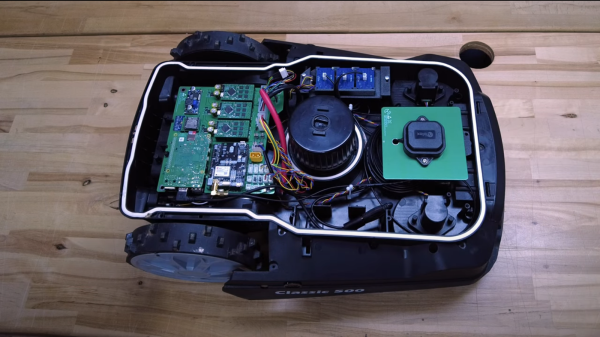
Robotic mowers are becoming a common sight in some places, enabled by the cost of motors and the needed control electronics being much lower, thanks to the pace of modern engineering. But, in many cases, they still appear to be really rather dumb, little more than a jacked up bump-and-go with a spinning blade. [Clemens Elflein] has taken a cheap, dumb mower and given it a brain transplant based around a Raspberry Pi 4 paired up with a Raspberry Pi Pico for the real time control side of things. [Clemens] is calling this OpenMower, with the motivation to create an open source robot mower controller with support for GPS navigation, using RTK for extra precision.

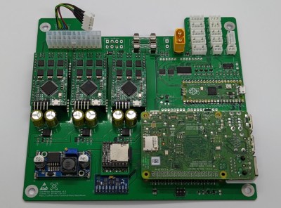
The donor robot was a YardForce Classic 500, and after inspection of the control PCB, it looks like many other robot mower models are likely to use the same controller and thus be compatible with the openmower platform. A custom mainboard houses the Pi 4 and Pico, an ArduSimple RTK GPS module (giving a reported navigational accuracy of 1 cm,) as well as three BLDC motor drivers for the wheels and rotor. Everything is based on modules, plugging into the mainboard, reducing the complexity of the project significantly. For a cheap mower platform, the Yardforce unit has a good build quality, with connectors everywhere, making OpenMower a plug and play solution. Even the user interface on top of the mower was usable, with a custom PCB below presenting some push buttons at the appropriate positions.

OpenMower mainboard

Motor control is courtesy of the xESC project, which provides FOC motor control for low cost, interfacing with the host controller via a serial link. This is worth looking into in its own right! On the software side of things, [Clemens] is using ROS, which implements the low level robot control, path planning (using code taken from Slic3r) as well a kinematics constraints for object avoidance. The video below, shows how simple the machine is to operate — just drive it around the perimeter of lawn with a handheld controller, and show it where obstacles such as trees are, and then set it going. The mower is even capable of mowing multiple lawns, making the journey between them automatically!

Robotic mower projects are not new around here, here’s the mysterious TK with an interesting take, another using RTK GPS for good (or possibly bad) and quite probably the jankiest one we’ve seen in a while, which uses a LoRa base-station to transmit RTK corrections. We’d recommend keeping well away from that last one.

Continue reading “OpenMower: Open Source Robotic Lawn Mower With RTK GPS”

Low Power Mode For Custom GPS Tracker

GPS has been a game-changing technology for all kinds of areas. Shipping, navigation, and even synchronization of clocks have become tremendously easier thanks to GPS. As a result of its widespread use, the cost of components is also low enough that almost anyone can build their own GPS device, and [Akio Sato] has taken this to the extreme with efforts to build a GPS tracker that uses the tiniest amount of power.

This GPS tracker is just the first part of this build, known as the air station. It uses a few tricks in order to get up to 30 days of use out of a single coin cell battery. First, it is extremely small and uses a minimum of components. Second, it uses LoRa, a low-power radio networking method, to communicate its location to the second part of this build, the ground station. The air station grabs GPS information and sends it over LoRa networks to the ground station which means it doesn’t need a cellular connection to operate, and everything is bundled together in a waterproof, shock-resistant durable case.

[Akio Sato] imagines this unit would be particularly useful for recovering drones or other small aircraft that can easily get themselves lost. He’s started a crowdfunding page for it as well. With such a long battery life, it’s almost certain that the operator could recover their vessel before the batteries run out of energy. It could also be put to use tracking things that have a tendency to get stolen.

Vacuum “Tube” Might Replace GPS One Day

GPS and similar satellite navigation systems changed everything. The modern generation is far less likely to have had to fold a service station map or ask someone for directions on the side of the road. But GPS isn’t perfect. You need to see the sky, for one thing. For another, an adversary could jam or take down your satellites. Even a natural disaster could temporarily or permanently knock out your access to the satellites.

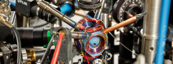
The people at Sandia National Labs worry about things like that and they want to replace GPS with quantum accelerometers and gyroscopes. The problem: those things take expensive and bulky vacuum systems and lasers. Sandia, however, has had a sealed device about the size of an avocado that weighs about a pound that could possibly do the job. Their goal is to see it work without maintenance for four more years.

This is no ordinary vacuum tube, though. It is made of titanium and sapphire. By itself, the device doesn’t do much of anything, but it shows that rubidium can be contained in a sealed chamber with no additional pumping. These quantum sensors aren’t anything new, but a tiny self-contained cold-atom sensor can pave the way for putting these sensors in vehicles like ships, aircraft, and ground vehicles. Submarines, which don’t usually have a clear shot at the sky without floating an antenna, are also candidates for the new technology.

A navigation system based on this technology uses a laser to cool the subject atoms and then measures their movements. This allows very precise determination of acceleration and rotation which allows for a more precise inertial navigation system.

If you need a refresher on how GPS works, we can explain it. If you think the idea of a module containing rubidium is far-fetched, don’t forget you can already get them for precision clock work.

[Nick Rehm] explains the workings of a gps-less self guided drone

Autonomous Drone Dodges Obstacles Without GPS

If you’re [Nick Rehm], you want a drone that can plan its own routes even at low altitudes with unplanned obstacles blocking its way. (Video, embedded below.) And or course, you build it from scratch.

Why? Getting a drone that can fly a path and even return home when the battery is low, signal is lost, or on command, is simple enough. Just go to your favorite retailer, search “gps drone” and you can get away for a shockingly low dollar amount. This is possible because GPS receivers have become cheap, small, light, and power efficient. While all of these inexpensive drones can fly a predetermined path, they usually do so by flying over any obstacles rather than around.

[Nick Rehm] has envisioned a quadcopter that can do all of the things a GPS-enabled drone can do, without the use of a GPS receiver. [Nick] makes this possible by using algorithms similar to those used by Google Maps, with data coming from a typical IMU, a camera for Computer Vision, LIDAR for altitude, and an Intel RealSense camera for detection of position and movement. A Raspberry Pi 4 running Robot Operating System runs the autonomous show, and a Teensy takes care of flight control duties.

What we really enjoy about [Nick]’s video is his clear presentation of complex technologies, and a great sense of humor about a project that has consumed untold amounts of time, patience, and duct tape.

We can’t help but wonder if DARPA will allow [Nick] to fly his drone in the Subterranean Challenge such as the one hosted in an unfinished nuclear power plant in 2020.

Continue reading “Autonomous Drone Dodges Obstacles Without GPS”

GPS? With Starlink, We Don’t Need It Any More!

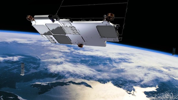
To find your position on the earth’s surface there are a variety of satellite-based navigation systems in orbit above us, and many receiver chipsets found in mobile phones and the like can use more than one of them. Should you not wish to be tied to a system produced by a national government though, there’s now an alternative. It comes not from an official source though, but as a side-effect of something else. Researchers at Ohio State University have used the Starlink satellite broadband constellation to derive positional fixing, achieving a claimed 8-metre accuracy.

The press release is light on information about the algorithm used, but since it mentions that it relies on having advance knowledge of the position and speed of each satellite we’re guessing that it measures the Doppler shift of each satellite’s signal during a pass to determine a relative position which can be refined by subsequent observations of other Starlink craft.

The most interesting takeaway is that while this technique leverages the Starlink network, it doesn’t have any connection to the service itself. Instead it’s an entirely passive use of the satellites, and though its accuracy is around an order of magnitude less than that achievable under GPS it delivers a position fix still useful enough to fit the purposes of plenty of users.

Earlier in the year there was some amusement when the British government bought a satellite broadband company under the reported impression it could plug the gap left by their withdrawal from the European Galileo project. Given this revelation, maybe they were onto something after all!

Thanks [Renze] for the tip.

the microGPS pipeline

MicroGPS Sees What You Overlook

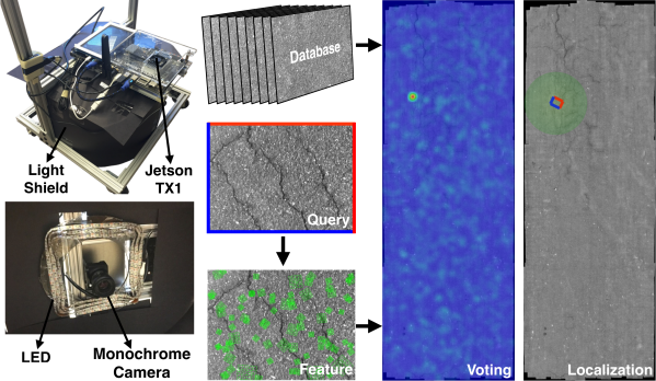
GPS is an incredibly powerful tool that allows devices such as your smartphone to know roughly where they are with an accuracy of around a meter in some cases. However, this is largely too inaccurate for many use cases and that accuracy drops considerably when inside such as warehouse robots that rely on barcodes on the floor. In response, researchers [Linguang Zhang, Adam Finkelstein, Szymon Rusinkiewicz] at Princeton have developed a system they refer to as MicroGPS that uses pictures of the ground to determine its location with sub-centimeter accuracy.

The system has a downward-facing monochrome camera with a light shield to control for exposure. Camera output feeds into an Nvidia Jetson TX1 platform for processing. The idea is actually quite similar to that of an optical mouse as they are often little more than a downward-facing low-resolution camera with some clever processing. Rather than trying to capture relative position like a mouse, the researchers are trying to capture absolute position. Imagine picking up your mouse, dropping it on a different spot on your mousepad, and having the cursor snap to a different part of the screen. To our eyes that are quite far away from the surface, asphalt, tarmac, concrete, and carpet look quite uniform. But to a macro camera, there are cracks, fibers, and imperfections that are distinct and recognizable.

They sample the surface ahead of time, creating a globally consistent map of all the images stitched together. Then while moving around, they extract features and implement a voting method to filter out numerous false positives. The system is robust enough to work even a month after the initial dataset was created on an outside road. They put leaves on the ground to try and fool the system but saw remarkably stable navigation.

Their paper, code, and dataset are all available online. We’re looking forward to fusion systems where it can combine GPS, Wifi triangulation, and MicroGPS to provide a robust and accurate position.

Video after the break.

Continue reading “MicroGPS Sees What You Overlook”