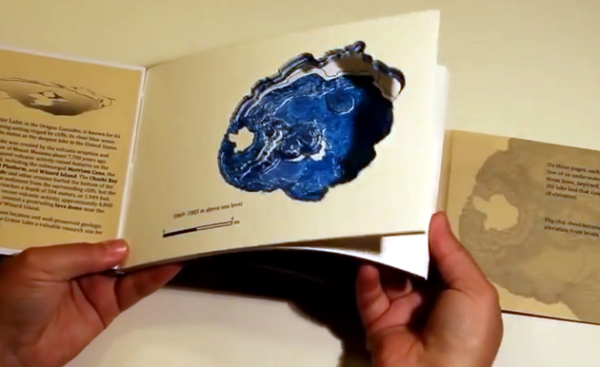
We first saw this Bathymetric Book at our local hackerspace, Sector67, quite some time ago. [Caroline Rose] gave a seven minute presentation on the project as part of the monthly meeting which is open to the public. You can get a pretty good feel for the book that includes a to-scale depth representation of Crater Lake in the introductory post which she recently published. Each page makes up one topographical ring of the lake. Put them all together and you’ve got a really amazing way to explore the watery depths of the deepest lake in the United States.
The book you see above is hand made. She downloaded the depth data from the US Geological Survey, then put it through some processing in order to print one elevation level on each page. That’s when the work really began. She cut out every page by hand! The four-plus hour task was grueling. And just for a bit of added punishment she even made a second book. But at Tuesday night’s follow-up presentation she said never again.
[Caroline] developed a much faster and still accurate technique for producing the bound-book depth maps. She is using a laser cutter and a different binding technique. By using folded packets of paper, rather than individual pages, she is able to cut out three double-sheets at once — including holes for the binding thread and the outline of the finished pages themselves. This cuts the process down to about four minutes of laser cutter time.
For now you’ll have to settle for a time-lapse video of the hand-cutting process (embedded below). But we hope to post an update when she makes more information about the laser-cut version available.
Continue reading “Making A Bathymetric Book By Hand And Searching For An Easier Way”