AI-Powered Bumper Sticker Provides Context-Sensitive Urban Camouflage

While we absolutely support the right of everyone to express their opinions, it seems to us that it’s rarely wise to turn your vehicle into a mobile billboard for your positions. Aside from potentially messing up the finish on your car, what’s popular and acceptable at home might attract unwanted attention while traveling abroad, leading to confrontations that might make your trip a little more eventful than it needs to be.

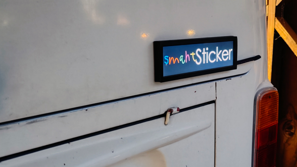
So why not let technology help you speak your mind in a locally sensitive manner? That’s the idea behind [Pegor]’s “smahtSticker”, an AI-powered bumper sticker that provides the ultimate in context-sensitive urban camouflage. The business end of smahtSticker — we’re going to go out on a limb here and predict that [Pegor] hails from the Boston area — is an 8.8″ (22-cm) wide HDMI display capable of 1920×480 resolution. That goes on the back of your car and is driven by a Raspberry Pi Zero with a GPS module. The Pi grabs a geolocation every second, and if you’ve moved more than 25 feet (7.6 m) — political divisions are at least that granular in the US right now, trust us — it grabs your current ZIP code using GeoPy. That initiates a query to the OpenAI API to determine the current political attitudes in your location, which is used to select the right slogan to display. You’ll fit in no matter where you wander — wicked smaht!

Now, of course, this is all in good fun, and with tongue planted firmly in cheek. The display isn’t weatherized at all, so that would need to be addressed if one felt like fielding this. Also, ZIP codes may be good for a lot of things, but it’s not the best proxy for political alignment, so you might want to touch that part up.

Water Level Sensor Does Not Use Water Level Sensor

When interfacing with the real world, there are all kinds of sensors available which will readily communicate with your microcontroller of choice. Moisture, pH, humidity, temperature, location, light, and essentially every other physical phenomenon are readily measured with a matching sensor. But if you don’t have the exact sensor you need, it’s sometimes possible to use one sensor as a proxy for another.

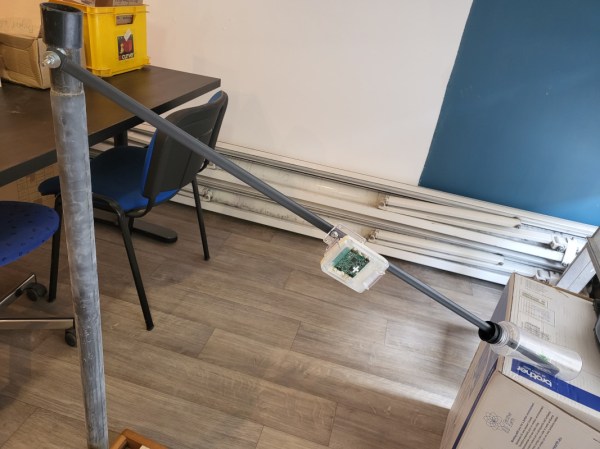
[Brian Wyld] needed a way to monitor the level of a remote body of water but couldn’t use a pressure or surface-level sensor, so he used a sensor typically intended for geolocation instead. This particular unit, an STM-type device with a built-in accelerometer, is attached to a rotating arm with a float at one end. As the arm pivots, the microcontroller reports its position and some software converts the change in position to a water level. It’s also paired with a LoRa radio, allowing it to operate off-grid.

Whether there is a design requirement to use an esoteric sensor to measure something more common, or a personal hardware limitation brought about by a shallow parts drawer, there’s often a workaround like this one that can accomplish the job. Whatever the situation, we do appreciate hacking sensors into other types of sensors just as much as anything else.

Hackaday Links Column Banner

Hackaday Links: November 7, 2021

More trouble for Hubble this week as the space observatory’s scientific instruments package entered safe mode again. The problems started back on October 25, when the Scientific Instrument Command and Data Handling Unit, or SI C&DH, detect a lack of synchronization messages from the scientific instruments — basically, the cameras and spectrometers that sit at the focus of the telescope. The issue appears to be different from the “payload computer glitch” that was so widely reported back in the summer, but does seem to involve hardware on the SI C&DH. Mission controller took an interesting approach to diagnosing the problem: the dusted off the NICMOS, or Near Infrared Camera and Multi-Object Spectrometer, an instrument that hasn’t been used since 1998. Putting NICMOS back into the loop allowed them to test for loss of synchronization messages without risking the other active instruments. In true hacker fashion, it looks like the fix will be to change the software to deal with the loss of sync messages. We’ll keep you posted.

What happened to the good old days, when truck hijackings were for things like cigarettes and booze? Now it’s graphics cards, at least according to a forum post that announced the theft of a shipment of EVGA GeForce RTX 30-series graphics cards from a delivery truck. The truck was moving the cards from San Francisco to the company’s southern California distribution center. No word as to the modus operandi of the thieves, so it’s not clear if the whole truck was stolen or if the cards “fell off the back.” Either way, EVGA took pains to note that receiving stolen goods is a crime under California law, and that warranties for the stolen cards will not be honored. Given the purpose these cards will likely be used for, we doubt that either of these facts matters much to the thieves.

Remember “Jet Pack Man”? We sure do, from a series of reports by pilots approaching Los Angeles International airport stretching back into 2020 and popping up occasionally. The reports were all similar — an object approximately the size and shape of a human, floating aloft near LAX. Sightings persisted, investigations were launched, but nobody appeared to know where Jet Pack Man came from or what he was flying. But now it appears that the Los Angeles Police may have identified the culprit: one Jack Skellington, whose street name is the Pumpkin King. Or at least a helium balloon version of the gangly creature, which is sure what an LAPD helicopter seems to have captured on video. But color us skeptical here; after all, they spotted the Halloween-themed balloon around the holiday, and it’s pretty easy to imagine that the hapless hero of Halloween Town floated away from someone’s front porch. More to the point, video that was captured at the end of 2020 doesn’t look anything like a Skellington balloon. So much for “case closed.”

Speaking of balloons, here’s perhaps a more productive use for them — lifting a solar observatory up above most of the atmosphere. The Sunrise Solar Observatory is designed to be lifted to about 37 km by a balloon, far enough above the Earth’s ozone layer to allow detailed observation of the Sun’s corona and lower atmosphere down into the UV range of the spectrum. Sunrise has already flown two successful missions in 2009 and 2013 which have netted over 100 scientific papers. The telescope has a one-meter aperture and automatic alignment and stabilization systems to keep it pointed the right way. Sunrise III is scheduled to launch in June 2022, and aims to study the flow of material in the solar atmosphere with an eye to understanding the nature of the Sun’s magnetic field.

And finally, what a difference a few feet can make. Some future Starlink customers are fuming after updating the location on their request for service, only to find the estimated delivery date pushed back a couple of years. Signing up for Starlink satellite service entails dropping a pin on a map to indicate your intended service location, but when Starlink put a new, more precise mapping app on the site, some eager pre-order customers updated their location to more accurately reflect where the dish will be installed. It’s not clear if the actual location of the dish is causing the change in the delivery date, or if just the act of updating an order places you at the bottom of the queue. But the lesson here may be that with geolocation, close enough is close enough.

Open Source Pizza Compass Will Show You The Way

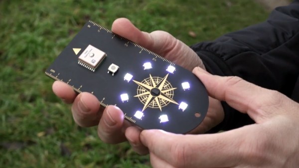
In Pirates of the Caribbean, Captain Jack Sparrow has an enchanted compass that points to what the holder wants most in life. The Pizza Compass created by [Joe Grand] is basically the same thing, except it’s powered by a Particle Boron instead of a voodoo spell. Though depending on who’s holding the thing, we imagine they’d even point in the same direction.

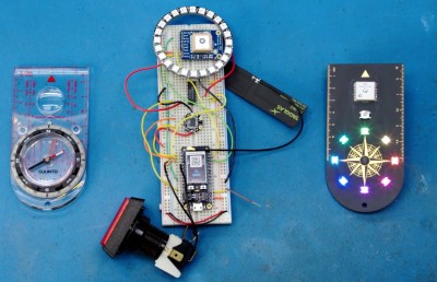
[Joe] was tasked by Wired to design and produce the Pizza Compass in three weeks, a process which was documented in the video below. Being the Badgelife luminary that he is, the final product looks far more attractive than it has any business being. In addition to the Particle Boron that slots in on the back of the handheld PCB, there’s a GlobalTop PA6H GPS module, a LSM303DLHC compass, and eight NeoPixels that correspond to the points on the silkscreen compass.

From prototype to final product.

Using the device is simple, just press the button and then walk around trying to keep the top-most LED lit. Behind the scenes, the Boron is pulling down the coordinates of the closest pizza place as reported by Google’s API, and comparing that to the user’s current GPS location. In practice that means the Pizza Compass isn’t concerned with nuances like streets or buildings, so its up to the user to figure out how best to stay on the desired heading. So rather than just following some turn-by-turn directions, there’s some proper navigation involved if you want that fresh slice.

If you don’t like pizza, you could reprogram the compass to point to whatever quest-worthy resource you wish. As explained at the end of the video, [Joe] wanted this to be an open source project so it could easily be adapted for different tasks by the community. Though honestly, it’s pretty weird if you don’t like pizza.

We’ve actually covered a very similar device in the past that would point the user to the closest White Castle or Five Guys, but with all due respect to that project, the Pizza Compass is in another league. When you’ve got the talent and experience of [Joe Grand] on the team, even the most mundane of gadgets ends up looking like a piece of art.

Continue reading “Open Source Pizza Compass Will Show You The Way”

Meat-Seeking Raspberry Pi Leads You To Flavortown

[Patrick McDavid] and his wife had a legitimate work-related reason for writing some Python code that would pull the exact latitude and longitude of the individual locations within a national retain chain from Google’s Geocoding API. But don’t worry about that part of the story. What’s important now is that this simple concept was then expanded into a pocket-sized device that will lead the holder to the nearest White Castle or Five Guys location.

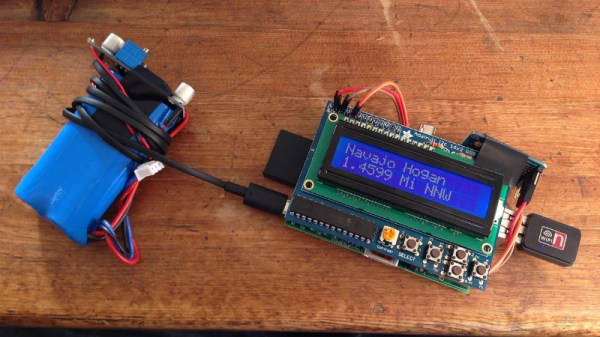
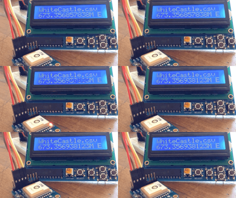
The device, which [Patrick] lovingly referrers to as the “Cheeseburger Compass”, uses a Raspberry Pi 3, an Adafruit 16×2 LCD with keypad, a GPS module, and the requisite battery and charger circuit to make it mobile. With the coordinates for the various places one can obtain glorious artery clogging meat circles loaded up, the device will give the user the cardinal direction and current distance from the nearest location of the currently selected chain.

[Patrick] has published the source code for this meat-seeking gadget on GitHub, but notes that most of it is just piecing together existing libraries and tools. As with many Python projects, it turns out there’s already a popular library to do whatever it is you were trying to do manually, so his early attempts at calculating distances and bearings were ultimately replaced with turn-key solutions. Though he did come up with a quick piece of code that would convert a compass heading in degrees to a cardinal direction that he couldn’t find a better solution for. Maybe he should make it a library…

Sadly the original Cheeseburger Compass got destroyed from being carried around so much, but at least it died doing what it loved. [Patrick] says a second version of the device would likely switch over to a microcontroller rather than the full Raspberry Pi experience, as it would make the device much smaller and greatly improve on the roughly two hour battery life.

This project reminds us of the various geocache devices we’ve covered in the past, but with the notable addition of hot sizzling meat. Talk about improving on a good thing.

Opt-Out Fitness Data Sharing Leads To Massive Military Locations Leak

People who exercise with fitness trackers have a digital record of their workouts. They do it for a wide range of reasons, from gathering serious medical data to simply satisfying curiosity. When fitness data includes GPS coordinates, it raises personal privacy concerns. But even with individual data removed, such data was still informative enough to spill the beans on secretive facilities around the world.

Strava is a fitness tracking service that gathers data from several different brands of fitness tracker — think Fitbit. It gives athletes a social media experience built around their fitness data: track progress against personal goals and challenge friends to keep each other fit. As expected of companies with personal data, their privacy policy promised to keep personal data secret. In the same privacy policy, they also reserved the right to use the data shared by users in an “aggregated and de-identified” form, a common practice for social media companies. One such use was to plot the GPS data of all their users in a global heatmap. These visualizations use over 6 trillion data points and can be compiled into a fascinating gallery, but there’s a downside.

This past weekend, [Nathan Ruser] announced on Twitter that Strava’s heatmap also managed to highlight exercise activity by military/intelligence personnel around the world, including some suspected but unannounced facilities. More worryingly, some of the mapped paths imply patrol and supply routes, knowledge security officers would prefer not to be shared with the entire world.

This is an extraordinary blunder which very succinctly illustrates a folly of Internet of Things. Strava’s anonymized data sharing obsfucated individuals, but didn’t manage to do the same for groups of individuals… like the fitness-minded active duty military personnel whose workout habits are clearly defined on these heat maps. The biggest contributor (besides wearing a tracking device in general) to this situation is that the data sharing is enabled by default and must be opted-out:

“You can opt-out of contributing your anonymized public activity data to Strava Metro and the Heatmap by unchecking the box in this section.” —Strava Blog, July 2017

We’ve seen individual fitness trackers hacked and we’ve seen people tracked through controlled domains before, but the global scope of [Nathan]’s discovery puts it in an entirely different class.

[via Washington Post]

Tracking Planes With An ESP8266

While there are apps that will display plane locations, [squix] wanted to build a dedicated device for plane spotting. The ESP8266 PlaneSpotter Color is a standalone device that displays a live map with plane data on a color TFT screen. This device expands on his PlaneSpotter project, adding a color display and mapping functions.

First up, the device needs to know where planes are. The ADS-B data that is transmitted from planes contains useful data including altitude, velocity, position, and an identifier unique to the aircraft. While commercial services exist for getting this data, the PlaneSpotter uses ADS-B Exchange. You can set up a Raspberry Pi to record this data, and provide it to ADS-B Exchange.

With the plane data being received from the ADS-B Exchange API, it’s time to draw to the screen. The JPEGDecoder fork for ESP8266 is used for drawing images, which are fetched from the MapQuest API as JPEGs.

Finally, geolocation is needed to determine where in the world the PlaneSpotter is. Rather than adding a GPS module, [squix] went with a cheap solution: WiFi geolocation. This uses identifying information and signal strengths from nearby WiFi access points to determine location. This project uses a public API by [Alexander Mylnikov], which returns a JSON object with longitude and latitude.

This project demonstrates what the ESP8266 is capable of, and brings together some neat techniques. If you’re looking to geolocate or display maps on an ESP8266, the code is available on Github.

Continue reading “Tracking Planes With An ESP8266”