Measuring Trees Via Satellite Actually Takes A Great Deal Of Field Work

Figuring out what the Earth’s climate is going to do at any given point is a difficult task. To know how it will react to given events, you need to know what you’re working with. This requires an accurate model of everything from ocean currents to atmospheric heat absorption and the chemical and literal behavior of everything from cattle to humans to trees.

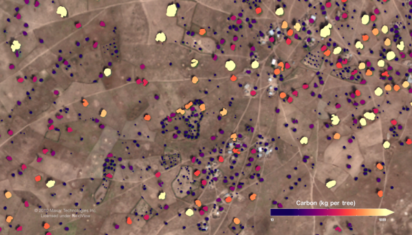
In the latter regard, scientists need to know how many trees we have to properly model the climate. This is key, as trees play a major role in the carbon cycle by turning carbon dioxide into oxygen plus wood. But how do you count trees at a continental scale? You’ll probably want to get yourself a nice satellite to do the job.

Continue reading “Measuring Trees Via Satellite Actually Takes A Great Deal Of Field Work”

How The Hunga Tonga Volcano Eruption Was Felt Around The World

On the 14th of January, 2022, the Hunga Tonga-Hunga Ha’apai volcano began a gigantic eruption that would go on to peak in ferocity the next day. The uninhabited island volcano would quickly make headlines as the country of Tonga was cut off the world and tsunamis bore out from the eurption zone.

In a volcanic event of this size, the effects can be felt around the world. With modern instruments, they can be properly understood too. Let’s take a look at how the effects of the Hunga Tonga eruption were captured and measured across the globe.

Continue reading “How The Hunga Tonga Volcano Eruption Was Felt Around The World”

Science Officer…Scan For Elephants!

If you watch many espionage or terrorism movies set in the present day, there’s usually a scene where some government employee enhances a satellite image to show a clear picture of the main villain’s face. Do modern spy satellites have that kind of resolution? We don’t know, and if we did we couldn’t tell you anyway. But we do know that even with unclassified resolution, scientists are using satellite imagery and machine learning to count things like elephant populations.

When you think about it, it is a hard problem to count wildlife populations in their habitat. First, if you go in person you disturb the target animals. Even a drone is probably going to upset timid wildlife. Then there is the problem with trying to cover a large area and figuring out if the elephant you see today is the same one as one you saw yesterday. If you guess wrong you will either undercount or overcount.

The Oxford scientists counting elephants used the Worldview-3 satellite. It collects up to 680,000 square kilometers every day. You aren’t disturbing any of the observed creatures, and since each shot covers a huge swath of territory, your problem of double counting all but vanishes.

Continue reading “Science Officer…Scan For Elephants!”

Decoding NOAA Satellite Images In Python

You’d be forgiven for thinking that receiving data transmissions from orbiting satellites requires a complex array of hardware and software, because for a long time it did. These days we have the benefit of cheap software defined radios (SDRs) that let our computers easily tune into arbitrary frequencies. But what about the software side of things? As [Dmitrii Eliuseev] shows, decoding the data satellites are beaming down to Earth is probably a lot easier than you might think.

Well, at least in this case. The data [Dmitrii] is after happens to be broadcast from a relatively old fleet of satellites operated by the National Oceanic and Atmospheric Administration (NOAA). These birds (NOAA-15, NOAA-18 and NOAA-19) are somewhat unique in that they fly fairly low and utilize a simple analog signal transmitted at 137 MHz. This makes them especially good targets for hobbyists who are just dipping their toes into the world of satellite reception.

Continue reading “Decoding NOAA Satellite Images In Python”

Spy Tech: Tiny Spy Plane Becomes Cold War Prize

What looks like something famous, is much smaller, and is embroiled in a web of cold war cloak-and-dagger intrigue? It sounds like the answer could be Mini-Me from the Austin Powers movies, but we were actually thinking of the D-21 supersonic spy drone. Never heard of it? It didn’t have a very long service life, but it was a tiny little unmanned SR-71 and is part of a spy story that would fit right in with James Bond, if not Austin Powers.

The little plane had a wingspan of only 19 feet — compared to the SR-71’s 56 foot span — and was 42 feet long. It could fly at about Mach 3.3 at 95,000 feet and had a range of around 3,500 miles. It shared many characteristics with its big brother including the use of titanium and a design to present a low RADAR cross-section.

The Spy Who Photographed Me

With today’s global economy and increased international cooperation, it is hard to remember just how tense the late 1960s were. Governments wanted to see what other governments were up to. Satellite technology would eventually fill that role, but even though spy satellites first appeared in 1959, they used film that had to be retrieved by an airplane as it fell from the sky and then processed. Not exactly real time. More effective satellites would have to wait for better imaging technology — see the video below for just how bad those old satellite images were. That left spy planes to do the bulk of the work.

Continue reading “Spy Tech: Tiny Spy Plane Becomes Cold War Prize”

Downloading Satellite Images Via FM Radio

Did you know weather satellites transmit their weather images over an FM frequency? And now that you know… You can intercept them yourself with a $10 FM radio dongle!

American NOAA weather satellites are in a polar orbit around earth, and each one will pass the same point approximately every 12 hours. When it is overhead, the signal is strong enough to receive. After [Matt] found out this tidbit of knowledge, he had to learn how to intercept the images himself.

The satellites transmit the images over the 137MHz band, and using a radio tuner USB dongle, you can record the transmission and then decode it into a picture. He used CubicSDR to tune and record the signal, and then Soundflower to pull out interference, and finally WXtoIMG — which starts recording when the satellite is above, and decodes the image.

[Thanks for the tip Amirgon!]