A recent writeup by Tom Nardi about using the 6502-based NES to track satellites brought back memories of my senior project at Georgia Tech back in the early 80s. At our club station W4AQL, I had become interested in Amateur Radio satellites. It was quite a thrill to hear your signal returning from space, adjusting for Doppler as it speeds overhead, keeping the antennas pointed, all while carrying on a brief conversation with other Earth stations or copying spacecraft telemetry, usually in Morse code.
satellite tracking10 Articles
Open Source Intel Helps Reveal US Spy Sat Capabilities
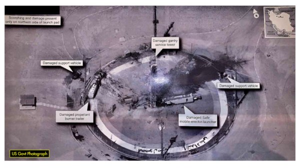
On the 30th August 2019, the President of the United States tweeted an image of an Iranian spaceport, making note of the recent failed Safir launch at the site. The release of such an image prompted raised eyebrows, given the high resolution of the image, and that it appeared to be a smartphone photo taken of a classified intelligence document.
Inquisitive minds quickly leapt on the photo, seeking to determine the source of the image. While some speculated that it may have been taken from a surveillance aircraft or drone, analysis by the satellite tracking community disagreed.
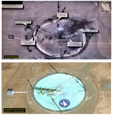
The angle of shadows in the image was used to determine the approximate time that the image was taken. Additionally, through careful comparison with existing satellite images from Google Maps, it was possible to infer the azimuth and elevation of the camera. Positions of military satellites aren’t made public, but amateur tracking networks had data placing satellite USA 224 at a similar azimuth and elevation around the time the image was taken.
With both the timing and positioning pointing to USA 224, evidence seems conclusive that this KH-11 satellite was responsible for taking the image. The last confirmed public leak of a Keyhole surveillance image was in 1984, making this an especially rare occurrence. Such leaks are often frowned upon in the intelligence community, as nation states prefer to keep surveillance capabilities close to their chest. The Safir images suggest that USA 224 has a resolution of 10cm per pixel or better – information that could prove useful to other intelligence organisations.
It’s not the first time we’ve covered formerly classified information, either – this teardown of a Soviet missile seeker bore many secrets.
See Starlink’s “Space Train” Before It Leaves The Station
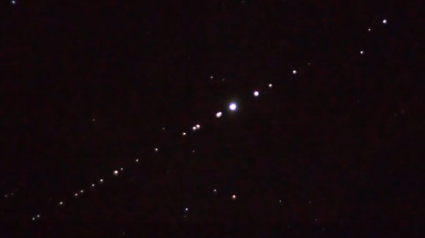
Have you looked up into the night sky recently and seen a bizarre line of luminous dots? Have you noticed an uptick in the number of UFO reports mentioned in the news and social media? If so, you may have already been touched by what many have come to affectionately call Elon Musk’s “Space Train”: a line of tightly grouped Starlink satellites that are making their way around the globe.
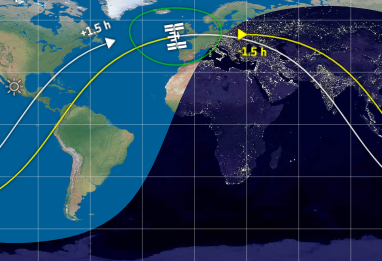
Some have wondered what’s so unique about the Starlink satellites that allows them to be visible from the ground by the naked eye, but that’s actually nothing new. It’s all about being in the right place at the right time, for both the observer and the spacecraft in question. The trick is having the object in space catch the light from the Sun when it has, from the observer’s point of view, already set. It’s essentially the same reason the Moon shines at night, but on a far smaller scale.
The phenomena is known as “satellite flare”, and chasing them is a favorite pastime of avid sky watchers. If you know when and where to look on a clear night, you can easily spot the International Space Station as it zips across the sky thanks to this principle. NASA even offers a service which uses email or SMS to tell you when the ISS should be visible from your location.
What makes the Starlink satellites unique isn’t that we can see them from the ground, but that there’s so many of them flying in a straight line. The initial launch released 60 satellites in a far tighter formation than we’ve ever seen before; Elon even warned that collisions between the individual Starlink satellites wasn’t out of the realm of possibility. The cumulative effect of these close proximity satellite flares is a bit startling, and understandably has people concerned about what the night sky might look like when all 12,000 Starlink satellites are in orbit.
The good news is, the effect is only temporary. As the satellites spread out and begin individual maneuvers, that long line in the sky will fade away. But before Elon’s “Space Train” departs for good, let’s look at how it was created, and how you can still catch a glimpse of this unique phenomena.
Continue reading “See Starlink’s “Space Train” Before It Leaves The Station”

Amazon Creates Distributed Satellite Ground Stations
Here’s an interesting thought: it’s possible to build a cubesat for perhaps ten thousand dollars, and hitch a ride on a launch for free thanks to a NASA outreach program. Tracking that satellite along its entire orbit would require dozens or hundreds of ground stations, all equipped with antennas and a connection to the Internet. Getting your data down from a cubesat actually costs more than building a satellite.
This is the observation someone at Amazon must have made. They’ve developed the AWS Ground Station, a system designed to downlink data from cubesats and other satellites across an entire orbit. Right now, Amazon only has two ground stations attached, but they plan to have a dozen in place by the middle of next year. Each of these ground stations are associated with a particular AWS region (there are a total of sixteen AWS regions, which might limit the orbital coverage of the AWS Ground Station system), and consists of an antenna, an alt-az mount, and a gigantic bank of servers and hard drives to capture data from satellites orbiting overhead.
The Amazon blog post goes over how easy it is to capture data from a satellite, and it’s as easy as getting a NORAD ID, logging into your AWS account, and clicking a few buttons.
It should go without mention that this is the exact same idea behind SatNOGS, an Open Source global network of satellite ground stations and winner of the 2014 Hackaday Prize. One of their ground stations is what’s pictured at the top if this article. Right now, SatNOGS has over seventy ground stations in the network, including a few stations that are in very useful locations like the Canary Islands. The SatNOGS network already has a lot more coverage than the maximum of sixteen locations where Amazon has their data centers — made possible by its open nature. Congrats to the SatNOGS team once again for creating something so useful, and doing it four years before Amazon.
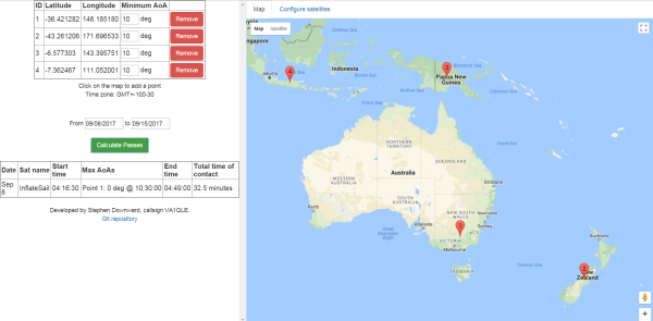
Satellite Tracking With Friends
If you’re in the mood to track satellites, it’s a relatively simple task to look up one of a multitude of websites that can give you a list of satellites visible from your location. However, if you’re interested in using satellites to communicate with far-flung friends, you might be interested in this multi-point satellite tracker.
[Stephen Downward VA1QLE] developed the tracker to make it easier to figure out which satellites would be simultaneously visible to people at different locations on the Earth’s surface. This is useful for amateur radio, as signals can be passed through satellites with ham gear onboard (such as NO-44), or users can even chat over defunct military satellites.
[Stephen] claims the algorithm is inefficient, but calculations are made in a matter of a few seconds, so we’re not complaining. While it was originally designed for just two stations, it works with a near-infinite number of points. [Stephen] recommends verifying the tracks with another tool once calculated to ensure accuracy. The tool is accessible here, and the code is up on GitHub for your perusal.
Perhaps now you need a cost-effective satellite-tracking antenna? [Paul] has you covered.
Building A Satellite-Tracking System With Cold War Tech
The things Hackaday readers come up with and post over on Hackaday.io never cease to amaze us. If you’ve never checked it out, be careful — you can easily spend hours (or weeks) of your life just skimming through the projects that have been logged there. Many of the builds use modern development tools like Arduino and Raspberry Pi, but every so often we come across a project that takes a more difficult road.
That’s the case with [Keplermatik’s] Cold War-era satellite-tracking project, also aptly named Keplermatik. This a build that’s still in progress, which just means you’ve got the privilege of following along as it progresses! What makes this project so special? Aside from the fact that it’s purpose is to track satellites, we think the sole use of vintage tech is a very cool and very ambitious goal.
[Keplermatik] plans to split the satellite-tracking console into two sides: an American-tech side for tracking the satellite’s position, and a Soviet-tech side for tuning the radio and positioning the antenna. The idea is that he’ll get to use vintage technology from both sides of the Iron Curtain. That should lead to some very interesting lessons about how these kinds of systems were designed by each side during the Cold War.
The build is still in its adolescence, but is definitely worth following along with. But, if you’re craving more Soviet tech and need it right now, be sure to check out this post on Russian Cold War vacuum tubes.
$25 Satellite Tracker Boasts “Usefulness Optional”
[Paul] is very up-front about the realities of his $25 Satellite Tracker, which aims a tape measure yagi antenna at a satellite of choice and keeps it tracking the satellite as it moves overhead. Does it work? Yes! Is it cheap? Of course! Is it useful? Well… did we mention it works and it’s cheap?
When [Paul] found himself wanting to see how cheaply he could make a satellite tracker he already had an RTL-SDR (which we have seen used for satellite communication before) and a yagi antenna made out of a tape measure, but wanted some way to automatically point the antenna at a satellite as it moved across the sky. He also wanted to see just how economically it could be done. Turns out that with some parts from China and code from SatNOGS (open-source satellite tracking network project and winner of the 2014 Hackaday Prize) you have most of what you need! A few modifications were still needed, and [Paul] describes them all in detail.
![]() So is a $25 Satellite Tracker useful? As [Paul] says, “Probably not.” He explains, “Most people want satellite trackers so that they can put them outside and then control the antenna from inside, which someone probably can’t do with mine unless they live in a really nice place or build a radome. […] Driving somewhere, setting it up correctly (which involves reprogramming the Arduino for every satellite), and then sitting around is pretty much the opposite of useful.”
So is a $25 Satellite Tracker useful? As [Paul] says, “Probably not.” He explains, “Most people want satellite trackers so that they can put them outside and then control the antenna from inside, which someone probably can’t do with mine unless they live in a really nice place or build a radome. […] Driving somewhere, setting it up correctly (which involves reprogramming the Arduino for every satellite), and then sitting around is pretty much the opposite of useful.”
It might not be the most practical but it works, it’s cool, he learned a lot, and he wrote up the entire process for others to learn from or duplicate. If that’s not useful, we don’t know what is.
Satellite tracking is the focus of some interesting projects. We’ve even seen a project that points out satellite positions by shining a laser into the sky.