Get Your Weather Images Straight From The Satellite

[Josh] has a series called Ham Radio Crash Course and a recent installment covers how you can grab satellite images directly from weather satellites. This used to be more of a production than it is now thanks to software defined radio (SDR). Josh also has another project using a 3D printer to make an antenna suitable for the job. You can see the video below.

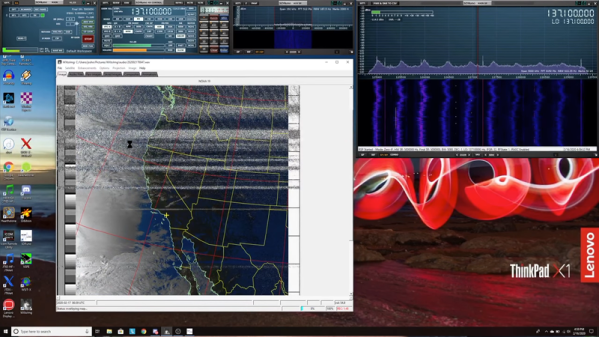
The software is the venerable WXtoImg program. This is abandonware, but the community has kept the software available. The program works on Linux, Windows, and Mac. The satellites in question operate around 137 MHz, but that’s easily in the range of even the cheap SDR dongles. [Josh] shows how to use a virtual audio cable on Windows to connect the output of the radio to the input of the WXtoImg program. Under Linux, you can do this with Pulse or Jack very easily without any extra hardware.

There’s some setup and calibration necessary for the software. You’ll also need the current orbital data and the program will tell you when you can find the next satellite passing overhead. Generally speaking you’ll want your antenna outside, which [Josh] solved by taking everything outdoors and having some lunch during the pass. It also takes some time to post-process the data into images and audio.

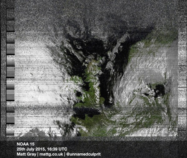
We know this isn’t new. But we did like [Josh’s] clear and up-to-date guide. We remember watching NOAA 15 as it started to lose its electronic mind.

Continue reading “Get Your Weather Images Straight From The Satellite”

The Death Of A Weather Satellite As Seen By SDR

What is this world coming to when a weather satellite that was designed for a two-year mission starts to fail 21 years after launch? I mean, really — where’s the pride these days?

All kidding aside, it seems like NOAA-15, a satellite launched in 1998 to monitor surface temperatures and other meteorologic and climatologic parameters, has recently started showing its age. This is the way of things, and generally the decommissioning of a satellite is of little note to the general public, except possibly when it deorbits in a spectacular but brief display across the sky.

But NOAA-15 and her sister satellites have a keen following among a community of enthusiasts who spend their time teasing signals from them as they whiz overhead, using homemade antennas and cheap SDR receivers. It was these hobbyists who were among the first to notice NOAA-15’s woes, and over the past weeks they’ve been busy alternately lamenting and celebrating as the satellite’s signals come and go. Their on-again, off-again romance with the satellite is worth a look, as is the what exactly is going wrong with this bird in the first place.

Continue reading “The Death Of A Weather Satellite As Seen By SDR”

Downloading Satellite Images Via FM Radio

Did you know weather satellites transmit their weather images over an FM frequency? And now that you know… You can intercept them yourself with a $10 FM radio dongle!

American NOAA weather satellites are in a polar orbit around earth, and each one will pass the same point approximately every 12 hours. When it is overhead, the signal is strong enough to receive. After [Matt] found out this tidbit of knowledge, he had to learn how to intercept the images himself.

The satellites transmit the images over the 137MHz band, and using a radio tuner USB dongle, you can record the transmission and then decode it into a picture. He used CubicSDR to tune and record the signal, and then Soundflower to pull out interference, and finally WXtoIMG — which starts recording when the satellite is above, and decodes the image.

[Thanks for the tip Amirgon!]