Rising To The Occasion: A Brief History Of Crewed High Altitude Balloons

Piccard inspects an instrument on his balloon (Image: Bundesarchiv, Bild 102-10382 / CC-BY-SA 3.0)

We think of human flight as a relatively modern affair, with a few claims to the first airplane all around the turn of the last century. But people flew much earlier than that by using hot air balloons as well as gas-filled ones. While the Montgolfier brothers get most of the credit for hot air ballooning in 1783, there are some reports that a Brazilian priest may have lifted himself with a balloon as early as 1709.

Regardless, we’ve had balloons a good century earlier than winged flight, if not longer. While the device is deceptively simple, it is possible to get a balloon to very high altitudes without a lot of specialized technology. Airplanes at high altitudes need a way to get enough oxygen to fuel their engines, or they have to rely on rockets. Either way, there are plenty of design and operational challenges.

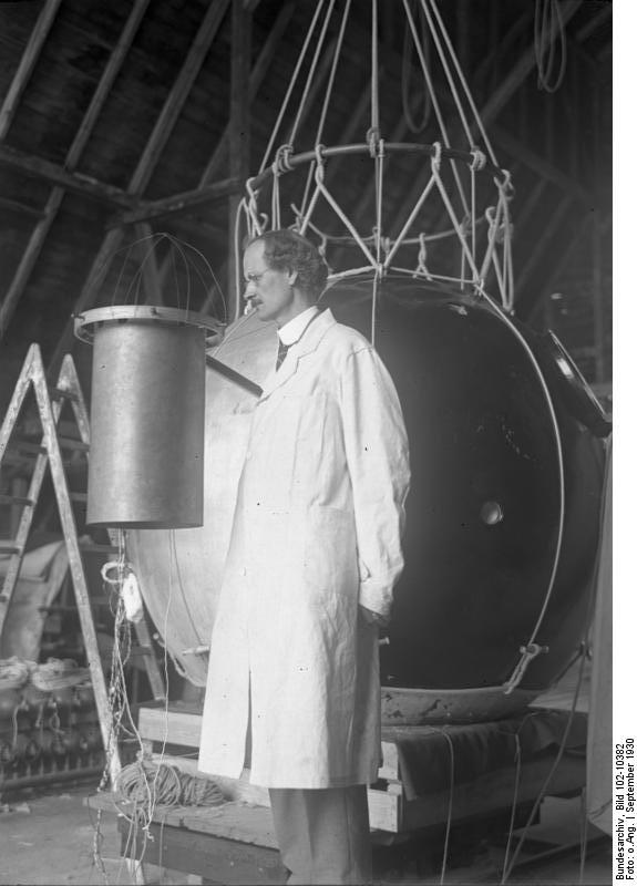
Balloons, of course, can simply rise to the occasion. Auguste Piccard and an assistant took a gas-filled balloon to 15,781 meters in 1931. Their gondola was pressurized, and they were the first humans to see the curvature of the Earth and the dark sky above. That record wouldn’t stand for long, though.

CCCP-1

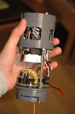
The Soviet Union was keenly interested in Piccard’s flight, and the Soviet Air Force set about to build a research vessel, CCCP-1 (in English, USSR-1), that flew in 1933. The envelope was a large amount of thin fabric impregnated with latex and filled with hydrogen. The air-tight gondola presented several challenges in design. Most of the science experiments were outside, of course, and in 1933, you didn’t have an Arduino and RC servos to control things.

Continue reading “Rising To The Occasion: A Brief History Of Crewed High Altitude Balloons”

GPS Guided Parachutes For High Altitude Balloons

Most amateur high altitude balloon payloads descend back to earth with a simple non-steerable parachute and can land hundreds of kilometers from the launch site in inaccessible areas. [Yohan Hadji] experienced this first-hand during a balloon launch conducted by his high school, which inspired him to R2Home, a GPS-guided parachute recovery system.

A Teensy runs the show, and controls a pair of sail winch servos pulling the brake lines

[Yohan]’s first challenge was to create a steerable parachute that can deploy reliably, so he started doing tests with a borrowed scale model paragliding wing. He quickly learned that a canopy aspect ratio of below two was needed for reliable deployment, so he started sewing his own canopies. Steering a parachute involves pulling on a pair of brake lines, one for each side of the parachute. A control stroke of about 20 cm was required, and [Yohan] found that RC sailboat winch servos work perfectly for this application. The entire system is designed to fit in a 7×40 cm tube, and the parachute is deployed with the help of a small drogue chute and a servo-operated release mechanism.

[Yohan] is working on a custom flight controller, built around a Teensy 4.1, GPS receiver, and digital compass. A possible alternative is Ardupilot, which we’ve seen used on several autonomous drones, gliders, and rovers. While this system might not be possible to return to the launch point, it could certainly close the gap, and land safely in a designated area.

So far [Yohan] has done a series of test drops from a drone at low altitude to test deployment and steering, using an RC controller. The project is open source, and the mechanical design files and control code is up on GitHub. As with most 16-year-olds, [Yohan]’s resources are limited, so feel free to drop him some financial help on the R2Home GoFundMe page. See the videos after the break for a development montage and project presentation. Continue reading “GPS Guided Parachutes For High Altitude Balloons”

Don’t Miss Watching This Solar Eclipse High Altitude Balloon Online

[Dan Julio] let us know about an exciting project that he and his team are working on at the Solid State Depot Makerspace in Boulder: the Solar Eclipse High Altitude Balloon. Weighing in at 1 kg and bristling with a variety of cameras, the balloon aims to catch whatever images are able to be had during the solar eclipse. The balloon’s position should be trackable on the web during its flight, and some downloaded images should be available as well. Links for all of that are available from the project’s page.

High altitude balloons are getting more common as a platform for gathering data and doing experiments; an embedded data recorder for balloons was even an entry for the 2016 Hackaday Prize.

If all goes well and the balloon is able to be recovered, better images and video will follow. If not, then at least a post-mortem of what the team thinks went wrong will be posted. Launch time in Wyoming is approximately 10:40 am Mountain Time (UTC -07:00) Mountain Daylight Time (UTC -06:00) on Aug 21 2017, so set your alarm!

Mexican Highschoolers Launch 30 High Altitude Balloons

No matter whether you call them “picosatellites” or “high altitude balloons” or “spaceblimps”, launching your own electronics package into the air, collecting some high-altitude photos and data, and then picking the thing back up is a lot of fun. It’s also educational and inspirational. We’re guessing that 264 students from 30 high schools in Aguascalientes Mexico have new background screens on their laptops today thanks to the CatSat program (translated here by robots, and there’s also a video to check out below).

Continue reading “Mexican Highschoolers Launch 30 High Altitude Balloons”

High Altitude Balloon Keeps Going

Here’s a post from the AMSAT-UK high altitude balloon blog. It’s a great story about a balloon cruising at about 12km above the Earth completing its sixth circumnavigation of the planet. That post is from October 4th, and two weeks later the balloon is still going strong. Right now it’s over the Baltic heading into Russia with no sign of stopping or popping any time soon.

globe
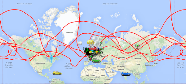
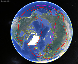
The balloon was launched July 12, 2014 from Silverstone, UK. In the 100 days since then, this balloon has covered 144168 kilometers and has crossed its launching longitude six times. Even if this balloon weren’t trapped at high latitudes (including coming within 9 km of the pole), this balloon has still travelled more than three times the equatorial circumference of the Earth.

The balloon was built by [Leo Bodnar] a.k.a. [M0XER] with a self-made plastic foil envelope. The solar-powered payload weighs only 11 grams. It’s an exceptional accomplishment and one that has smashed all the amateur high altitude balloon distance records we can find.

A Low-Cost Modular High Altitude Balloon Tracker With Mesh Networked Sensors

[Ethan] just tipped us about a project he and a few colleagues worked on last year for their senior design project. It’s a low-cost open hardware/software high altitude balloon tracker with sensors that form a mesh network with a master node. The latter (shown above) includes an ATmega644, an onboard GPS module (NEO-6M), a micro SD card slot, a 300mW APRS (144.39MHz) transmitter and finally headers to plug an XBee radio. This platform is therefore in charge of getting wireless data from the slave platforms, storing it in the uSD card while transmitting the balloon position via APRS along with other data. It’s interesting to note that to keep the design low-cost, they chose a relatively cheap analog radio module ($~40) and hacked together AFSK modulation of their output signal with hardware PWM outputs and a sine-wave lookup table.

The slave nodes are composed of ‘slave motherboards’ on which can be plugged several daughter-boards: geiger counters, atmospheric sensors, camera control/accelerometer boards. If you want to build your own system, be sure to check out this page which includes all the necessary instructions and resources.

Play-by-play Of A High Altitude Balloon Flight

[Greg Intermaggio] and [Shumit DasGupta] at Techsplosion launched a high altitude balloon last week that climbed to 90,000 feet above sea level somewhere over California. The play-by-play of the flight is one of the better stories we’ve seen on high altitude balloon builds.

The balloon, christened VGER-1, carried a SPOT satellite GPS messanger to send telemetry back to the ground. We’ve seen a few home brew balloon tracking devices, but [Greg] decided to use an off-the-shelf solution for the sake of simplicity. Like other balloons the VGER-1 carried a CanonPowershot camera with CHDK firmware.

Continue reading “Play-by-play Of A High Altitude Balloon Flight”