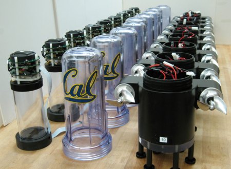
These cool looking little bots are part of a fleet of floating water sensors built by The Lagrangian Sensor Systems Laboratory (LSSL) at UC Berkeley, the Lawrence Berkeley National Laboratories (LBNL) and the California Department of Water Resources.
In an emergency such as a levee break, flood, or spill, they can be deployed to gather information in a way that is completely impossible with stationary sensors. These 17″ tall bots can steer with the help of their twin props and communicate water quality information back to the base via cellular communication and short wave radio. They describe the resulting data as being like a “google traffic map” showing speed, depth, and contamination of the water.
There’s a ton of detail on their site, including breakdowns of how the software and hardware are put together. There’s even a bit of the evolution of the hardware showing the abandoned previous models.










“levi break”
Also known as a catastrophic trouser failure?
autocorrect is sometimes auto incorrect.
It looks like they repurposed personal blenders as cases.
They look like cartridge water filter housing to me.
Yea, these guys really must love the ‘Magic Bullet’!
Where’s helen hunt when ya need her??
Gah! Why did I turn down that job at LBNL?
Anyway, these sensor-bots were test deployed last week (I think). Neat.
http://www.treehugger.com/clean-technology/swimming-robots-hit-california-rivers.html
– Robot
Can you say 17″ not 17′
:) Still very cool
“Exterminate! Exterminate!”
I’m going to have to do some whitepaper googling, but I want to say that some guys from Texas beat them to this 4 years ago. I also know anecdotal that UGA and Oregon have veeeeery similar modules. I’m assuming there is something inside or the fact that it uses props instead of jets to differentiate.
Sorry- one friend worked FEMA flood GIS, the other is a benthic plankton level specialist. I’ll have to email them and see what is different and report back.