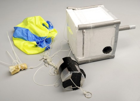
Take the risk of not recovering your hardware out of a near-space camera launch by streaming the data during flight. [Tim Zaman] is part of a team that developed the rig seen above. It sent 119 image back during the recent balloon launch. This included transmissions from as high as 36 kilometers.
The main hardware included a BeagleBoard with connected Webcam housed in a Styrofoam cooler for thermal protection. Pair that with a GPS module for location tracking, and a GPRS module for data transmission and you’re in business.
But that’s not all that went up. The team built a backup hardware module in case the primary failed. This one also had a GPS and GPRS radio, but was driven by an Arduino.
The radio connection made it easy to recover the hardware. GPS data led the team directly to the landing site. The package came to rest on the roof of a building, but we guess that’s more convenient than getting snagged at the top of a huge tree.
Don’t miss the hardware detail video that we’ve embedded after the break.
[youtube=http://www.youtube.com/watch?v=2jlkxkstruI&w=470]


awesome edit on the sound effects
I am skeptical that it does “transmissions from as high as 36 kilometers.”. I would think cellular signal won’t reach that far especially when the tower antennas are usually made directional and not pointing toward the sky.
Well i dont think they’re using Cellular network to “stream” the data , they use UHF Band (like in trucks…) and send the data as sound, decoder decode’s those to data and hey presto ! :D
transmission was on 434MHz as a licence exempt LPD [low power device].
The artcile says there was transmission on GPRS, but the transmission took place with a 434mhz little radio module.
Please check http://spacebits.eu/
1st launch May/2010
The radio they’re using is a Yaesu FT-817.
It does look like the 70cm band for the data, from the antenna.
They have several programs running but the telemetry appears to be done using fldigi, to which I contribute.
Leigh/WA5ZNU
It’s a slightly modified version of fldigi, which when it detects a telemetry string will upload it to the online tracker. It also handles decoding and uploading of the image packets.
http://ukhas.org.uk/projects:dl-fldigi
Tim posted the project also on a Dutch forum.
Discussion about how bad it is to enable a GSM at great heights ensued…. Tim claims the GSM/GPRS was only turned on when the payload was nearing the ground again.
Yes, the downlink was done in the 434MHz band, with only the allowed 10mW of power. This made it a challenge to recieve the streamed data, but they managed.
Oh, one more remark: You’d think things get pretty cold up there, right? Above 10km the temperature no longer drops a lot. Above 20km the temperature starts to rise again. Still pretty F***ing cold, but rising.
However at those heights there simply is so little air that equipment runs the risk of getting too hot as opposed to getting too cold….
I hate to grumble, but they really could use some “defogging” setup of some sort and a very, very wide lens maybe similar to the “Christmas ball lens” guy from last year (360 degree view). The data is cool but the photos are misguided and just fog from what I can see.
In this case the problem wasn’t the lens fogging up, but the camera hating the lighting conditions and overexposing everything.
What was so funny at 1:32, was it just the bursting of the balloon or was it something else?
The balloon bursted, and it took a picture of that – which it sent over live -. That’s pretty funny seeing as only 100+ images were sent over.
also it burst over a big lake
The big lake is called the “ijsselmeer”. It used to be a sea. Closed off in 1932. The payload drifted another while before it came back on the ground.
http://www.circuitsonline.net/forum/view/98376/1
What protocols did you use to transmit the images and GPS data? With HAM radio we use SSTV (Slow scan TV) and APRS (Automatic Packet Reporting System). Also what software did you use to track the GPS coordinates?
-Chris
AC2AM
Hi Chris,
The images where sent using SSDV – basically a way of transmitting JPEG images over RTTY with some error correction and ability to handle gaps in the data:
http://ukhas.org.uk/guides:ssdv
The telemetry itself is just text lines sent over the same RTTY signal, using this protocol:
http://ukhas.org.uk/communication:protocol
Both the image packets and telemetry strings are uploaded to a server, which can combine the data received by multiple stations, and it all gets displayed online live during the flight. It’s an amazing system.
I would really love to build , and fly a payload, but I have a hard time getting reliable commitment to have recovery teams. While the cost of building the payloads seem to have come down a lot, they aren’t yet in the we just can abandon it category yet.