Did you know weather satellites transmit their weather images over an FM frequency? And now that you know… You can intercept them yourself with a $10 FM radio dongle!
American NOAA weather satellites are in a polar orbit around earth, and each one will pass the same point approximately every 12 hours. When it is overhead, the signal is strong enough to receive. After [Matt] found out this tidbit of knowledge, he had to learn how to intercept the images himself.
The satellites transmit the images over the 137MHz band, and using a radio tuner USB dongle, you can record the transmission and then decode it into a picture. He used CubicSDR to tune and record the signal, and then Soundflower to pull out interference, and finally WXtoIMG — which starts recording when the satellite is above, and decodes the image.
[Thanks for the tip Amirgon!]


This is super cool. Must try this.
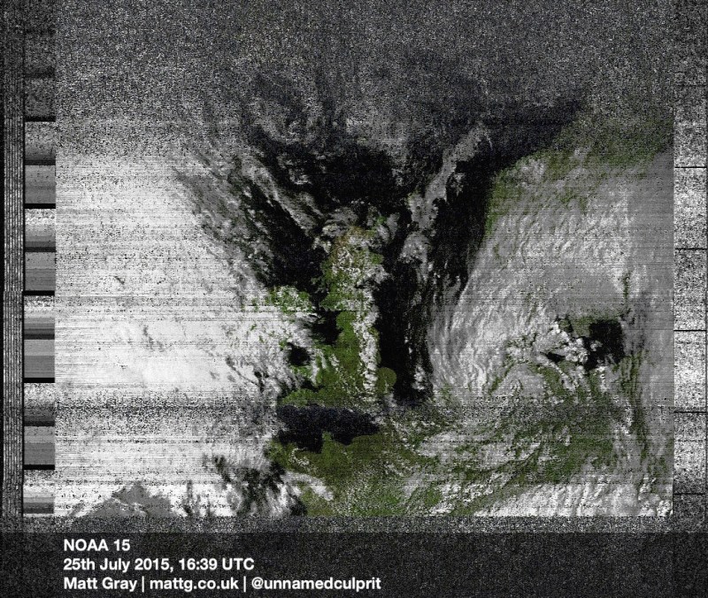
http://mattg.co.uk/projects/mercury/
That’s super cool…
what kind of antenna do people use for this and how do they make it
Quadrifilar helix for more difficulty and better quality, or turnstile for easy and less quality.
Yes, I hear the quadrifilar helicoidal are much better. Have a turnstyle and it does little until the bird is flying nearly overhead
Build a turnstile, they are simple, then add a longer grounded turnstile below it as a reflector. you make basically a 2 element turnstile yagi that will significantly increase the signal to noise ratio and works great.
They tend to work better than any of the fancy helix antennas and are dramatically easier to make.
Almost exactly the thing at QTH, even the 5W digi on the ISS doesn’t come in until around 30° above horizilion
While a quad helix or turnstyle are definitely recommended, I get away with a simple j-pole antenna on my setup.
Found this: http://www.gregorystrike.com/2010/05/16/quadrifilar-helix-antenna-137-mhz/
From ’10. Shows how to build a QHA.
I’ve used this one in the past — http://noaaport.poes-weather.com/download/jm-dca/MARTES_Double_Cross_Antenna.pdf — they key is to get it really high off the ground, though (my rooftop wasn’t high enough).
I remember when there were instructions to build cards for C= and other such machines for the same purpose. Never built one even though i was interested.
Oh by the way, i ran into this: http://hackaday.com/2011/10/20/grab-your-own-images-from-noaa-weather-satellites/
If you build a proper antenna and you don’t have to worry so much on the noise issue. ie….http://www.housedillon.com/?p=1461
Also Brian covered this in http://hackaday.com/2013/01/04/pictures-from-weather-satellites-with-a-usb-tv-tuner/
and Mike covered it in http://hackaday.com/2011/10/20/grab-your-own-images-from-noaa-weather-satellites/
So sorry i am not a hackaday historian like you, i need to get better at remembering who posted things years ago so i can bring them up today and look so smart!
Hackaday has a search function.
So does Google. Just add site:hackaday.com to your search query.
In the late eighties, Elector published a little circuit that together with a hacked FM radio could print the images directly on a facsimile. Depending on which satellite you tuned into, you could also print isobar weather maps.
I’ve been doing this for a couple months and it’s really cool! I made a little web app that decodes the audio signal in your browser. You can find it . It doesn’t do false coloring, but I’d love to implement it if anyone knows how. If you’ve got a satellite receiving setup, I’d be very interested to see what you think.
Ah it looks like I messed up formatting. Here’s the URL: http://jthatch.com/APT3000/APT3000.html
$10 FM radio dongle? clicks … nope, RTLSDR
Go to rtl-sdr.com and get something decent.
No need to spend more than about 10 bucks if you don’t need a full-on SDR. I see so many crooked eBay sellers cashing in on people. Drove me nuts! Good old R820-T for about 10 bucks can be endless fun. https://www.youtube.com/watch?v=srdG9HOCTmQ
Don’t buy random Chinese shit.
At least buy Chinese shit that has been tested and reviewed, decent compatibility and functionality
Hence the fact I shared the exact ones I have bought many of… I think I have had a dozen or so now and have given away several of them to just get people into the hobby. Feel free to pay as much as you like though. Those people charging 10X what they are worth will appreciate it. Cheers
Thanks for testing them for us.
Apparently, happy-team no longer sells the SDR on e-Bay.
Typo, NVM found it. haapy vs. happy
Oh and also to apologize for yesterday’s comment
Was not in my right mind, I am sorry.
No worries. Cheers
For $20 more you can get an old reliable Uniden Bearcat scanner. That’s what I use on my NOAA19 setup.
Very true. That’s what I started with too :) With the advent of all the digital/trunking a person might be able to grab a Bearcat or one of the RatShack Uniden Nascar versions for next to nothing now. Cheers
One of my fav uses for my SDR’s. I used to grab the NOAA images all the time and have done a few tutorials. If you really want a crazy image- grab them directly from Metor M2 satellite. Same equipment- crazy high detail images :) https://www.youtube.com/watch?v=ivQ0QuXBFsU
That’s awesome.
I have yet to be successful with LRPT from Meteor M.2. I suspect I need a MUCH better antenna to pull this off.
Don’t those NOAA satellites encode the signal in pretty much the same format as fax machines? I seem to remember projects from the 1980s and 1990s that would use an FM radio with air traffic bands to tune in, and a fax machine to print the pictures. None of that fancy modern “computer” stuff required :-)
===Jac
Now we need a cheap dongle in USB3.0 so we can see the HRPT not just APT…. I have yet to see a dongle that can handle 4.5MHz signal bandwidth and get it to the computer. If you know, please tell me. (Dongles, mind you, not $500 purpose-built SDR’s)…
Take two cheap sticks, remove the XtAL from one and and connect the XTAL from the other (short wire). Then you have two inphase. But you will never be able to start both at the exact same instance, so you will need to cross correlate the output from both in software to calculate the relative delay between the two and eliminate it using buffer offsets.
Now you will have two IQ streams that are phase coherent. The hard part is that these need to merged in the frequency domain so that instead of two 2.4MHz in bandwidth (no packet drops) you have something like 4.5MHz (you need a bit of frequency overlap to line them up in software)
The above is not easy, to be honest it is a right pain in the butt, but if you want to pay only $20 for hardware then you will need to put in $$$ for software development time.
A easier option might be the soon to be released “Airspy Dongle” (AKA “Airspy Light”) when it is available for about $100, I think that it will support 6MSPS.
How about running a little SiLabs Si570 part (or GPS/OCXO disciplined Si571) at 4X the clock frequency, then divide down to the clock frequency in quadrature with a couple of really fast flip flops (from Perigrine or Micrel?) Then stick the I&Q clocks respectively into two RTL-SDR dongles then plug the two dongles into two USB ports? Maybe an Si5351 would work as a cheaper alternative to the Si570/571 (Adafruit sells a breakout board) albeit with higher phase noise – and it may even have a way to get quadrature outputs.
I did this many years ago with a 486 and a scanner radio plugged into the soundcard a simple dipole antenna made from separating a speaker wire was more than enough to get a strong signal. It’s better if you can track the satellite online or with some software so you can know when it’s going to pass over your location. You’ll only have about a 2 or 3 minute window to catch the signal before you have to wait 12 hours to try it again.
I ran across an old Windows 95/98 laptop that had a similar setup. It had that equipment all mounted in a briefcase, with a portable printer.
It was one of a kind, but so was the 4-digit price tag. But somebody on eBay ended up happy with their new all-in-one NOAA weather laptop.
I did this too. When I was a student meteorologist living out in the boonies without any decent dial-up Internet, APT and WEFAX came in really handy for sat pics, wx charts, etc.
With a decent MW radio, you can still pic up many WEFAX stations around the world. Really handy when you’re on a boat in the middle of the ocean.
I’m with you guys, I did this back in the mid 90s using firstly a radio scanner plugged into a sound card then a RIGST RX2 kit I bought from the (now mostly defunct I suppose) remote imaging group (rig.org.uk). I still have my RX2 kit and several other half completed units – I have the circuit diagrams with them. I made a custom case for mine from a radio shack (Tandy for me…) aluminium project box. I remember that we had big issues with signal bleed from stronger pager signals at the time…
I really miss this aspect of my life, the closest I come to these days is the CB in my 4×4 or possibly my efforts with wifi antenna mods to my netbook.
Here is my try and setup: https://hackaday.io/page/527-satellite-tracking
Not bad at all. A few more elements on the yagi and a small pre-amp and you’ll get some stunning, clear pics!
Tittle is misleading.
Ssppeelliinngg is optional.
Nice, this packed in a go box was my idea, im glad to see someone did it. Quite useful even at this resolution , if you say…. lived in florida after a zombie apoc. Hurricanes would be pretty easy to spot.
Zombies and bad weather. This is something you never really see comined. Probably because zombies eat people and bad weather wipes out zombies, so bad weather ruins a good zombie outbreak story.
I figure its just an analog for what ever your reason for wanting a go box is . :D
> Did you know weather satellites transmit their weather images over an FM frequency?
Wrong terminology. It isn’t an FM frequency. FM is the modulation used at that specific frequency.
Logical next step is to see what else you can find up there no?
If you like these kinds of things you should definitely get into HAM Radio. There’s a ton of interesting stuff floating through the air. Plus you get to actually send commands to satellites, which in itself is a really cool thing to do.
Someone got an easy tutorial of how to do this in linux? I am really a beginner still with my rtl-sdr. Thanks!
Get yourself a copy of wxtoimge (http://www.wxtoimg.com/), a decent soundcard, and cheap scanner with decent antenna. I’m sure that APT with a RTLSDR in Linux can be done, but I’ve had better results using a Bearcat with my Linux setup.
Does anybody know, are these things still broadcast on HF too?
As a kid I really wanted to build the RadFax decoder found here: http://www.americanradiohistory.com/Archive-Poptronics/90s/90/PE-1990-11.pdf. For reasons mostly involving lack of money I never did even though I probably re-read that article 100 times.
Today, I know there is no point. I could do all the same plus more by just wiring the output of a receiver to my computer’s soundcard input and running some free software. Or, better yet.. use an RTL-SDR with a downconverter. But.. it would be very gratifying to achieve an old, abandoned goal. Even if I only ever use it once then put it away.
I thought it was too late. The necessary software was not included in the magazine and what are the odds of the author being reachable at the same address 25 years later? Then I found this: http://www.siliconchip.com.au/Shop/6/2569
I don’t know if/when I will ever bother but I’ve grabbed those files to save just in case! So, does anyone know if the HF signals this thing was originally meant to decode still exist? Or are the current satellite FM broadcasts compatible? If no and no then I guess I can still try using it for CW and RTTY. I wonder if this thing would work any better than the modern, software based decoders I have tried for morse code. None that I have tried worked very well at all.
Sure are. And as far as the US Coast Guard is concerned, there is still a huge point…
http://www.nws.noaa.gov/om/marine/rfax.pdf
I have QSLs for most everything on this list, except for a few south of the Equator…
And this is the decoder I use for radiofax…. http://www.dxsoft.com/en/products/seatty/
long ago I used to search and find obscure links/ftp’s from weather outfits where you could download the pictures fresh, but they kept closing them down after a few months so I got lazy and gave up. They were pretty damn good and large though.
And they also used to have them on shortwave. I wonder if it’s all straight satellite now or if shortwave still has satellite pictures too.
Yes, you can still receive on medium wave radio GOES pictures along with weather charts. Transmit times are listed for the various stations here — http://www.nws.noaa.gov/om/marine/rfax.pdf
got some sites i can browse of past projects etc?
I can’t think of any off hand other than my own (and it is offline at the moment). But the setup can be as simple as an old win95 laptop, SeaTTY, a soundcard, a decent receiver like a Sangean AT-803 (really old and hard to come by, but was what I started with) or Degen/Kaito 1103 (what I have now, and plentiful on eBay) , and a dipole antenna.
yeah i meant your site.
Here are some of my APT and Radiofax catches — http://75.71.71.105/appsremote.com/wefax/
You want current pics? Go to the source and download them there… http://www.goes.noaa.gov/