If you ever watch the original Star Trek, Captain Kirk and crew spend a lot of time mapping new parts of the galaxy. In fact, at least one episode centered on them taking images of some new part of space. It might not be new, but if you have a drone, you probably have accumulated a lot of frames of aerial imagery from around your house (or wherever you fly).
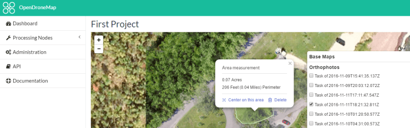
WebODM allows you to create georeferenced maps, point clouds and textured 3D models from your drone footage. The software is really an integration and workflow manager for Open Drone Map, which does most of the heavy lifting.
Getting started with WebODM or Open Drone Map is simple since they provide preconfigured Docker images. You don’t have to worry about assembling a bunch of dependencies to make everything work. There are other mapping applications in use, too. You can see a comparison of five popular choices in the video below. WebODM isn’t complete yet, but they intend to include mission planning and integration with mobile apps.
We’ve seen other mapping drones, but this has a lot of features and potential for growth. If you are interested in what people do with maps like this, we talked about how it is changing agriculture, although that’s not the only use, of course.


One interesting use for drones (http://newatlas.com/drones-virtual-reality-archaeology/46006/) is in mapping sites that otherwise would be inaccessible.
Not only that, but, if more images are taken as the dig progresses and the removed objects are 3d scanned, everything’s position in 3d space can be mapped.