Online mapping services pack in a lot of functionality that their paper-based forebearers could simply never imagine. Adding in metadata for local landmarks, businesses and respective reviews, and even live traffic data, they have the capability to deliver more information than ever before – and also correspondingly, shape human behaviour. [Simon Weckert] decided to explore this concept with a cheeky little hack.

The hack targets the manner in which Google collects live traffic data for display on Google Maps. When users load the app, Google takes location data from individual phones, tracking them as they travel along roadways. Large numbers of users travelling slowly down a road indicate there’s heavy traffic, and thus Google will display corresponding warnings on their maps and redirect users to take alternative paths.
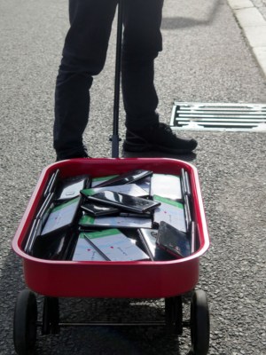
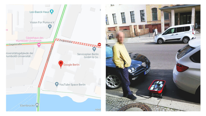
To pull off the hack, [Simon] placed 99 smartphones in a handy-cart, tugging them behind him as he walked slowly down a series of streets. In the video, this is overlaid with Google’s map data captured at the time. The app updates the maps with orange and red lines down the roads which [Simon] travelled with his 99 pretend drivers, indicating a traffic jam.
We’d love to know whether [Simon] ran 99 individual SIM cards with data access, or if the hack was perpetrated with the use of a WiFi hotspot for cheaper internet access. Reddit comments note that Google will likely swiftly work on methods to prevent such tomfoolery in future. It’s simple to see that 99 individual users reporting the exact same location and speed at the same time would be trivial to filter out from traffic monitoring in future.
It’s both a commentary on the power we give these apps in our lives, as well as a great demonstration of how easily such systems can be trifled with. We first reported on Google’s traffic monitoring back in 2009, when it was a technology in its infancy. Video after the break.


Simple way to avoid Google from detecting tomfoolery, 99 wagons about 10 apart.
I can just imaging the train of little red wagons been trundled down the street. Though in reality it WOULD create a traffic jam. Therefore the reported data would be correct
Disguise them as ducklings.
https://www.amazon.com/Make-Way-Ducklings-Robert-McCloskey/dp/0140564349/ref=asc_df_0140564349/?tag=hyprod-20&linkCode=df0&hvadid=312178232056&hvpos=1o1&hvnetw=g&hvrand=12672430023544057595&hvpone=&hvptwo=&hvqmt=&hvdev=c&hvdvcmdl=&hvlocint=&hvlocphy=1023197&hvtargid=pla-436095817625&psc=1&tag=&ref=&adgrpid=60258870937&hvpone=&hvptwo=&hvadid=312178232056&hvpos=1o1&hvnetw=g&hvrand=12672430023544057595&hvqmt=&hvdev=c&hvdvcmdl=&hvlocint=&hvlocphy=1023197&hvtargid=pla-436095817625
Hang them from 99 red balloons. No, wait…
How does Google currently differentiate a person driving from a person two meters away walking with a phone in their pocket ? It seems like a street full of people headed to work would create this same problem, particularly on the bridges he concentrates on.
Given that there’s an “artist’s statement” and no actual data or technical information, I’d be very tempted to call shenanigans on this.
I think it only works with maps being actually active on the cellphone, so pedestrians who need to use maps would probably be in “pedestrian mode” in order to take shortcuts. Also, actual cars zipping past slower moving phones (pedestrians, bikes, etc) would set the actual regular speed.
Possibly the accelerometer data too. A person walking would have regular intervals, while ones in the car doesn’t. I’ve always thought about how iPhone’s motion coprocessor detects this too.
You can get a pretty accurate idea if they’re driving by monitoring speed, if they go over running speed they must be driving, if they stop near bus stops they might be on a bus etc.
And if they’re in a traffic jam, they’re stopped.
I’d call shenanigans for a different reason: the displays look surprisingly legible for being outside on a sunny day.
A novel approach to a Waze uservoice idea by Veriloquous, “heard shearing”.
Disinformation structured can reclaim privacy
The problem with that is that it takes a lot of effort, and algorithms are constantly tweakers to eliminate noise, including when it’s intentionally introduced.
Could you do the same thing by running 99 Android virtual machines and GPS spoofing?
I like it!
I could see that as a possible plot point in a film, like another remake of the “The Italian Job” to mess up traffic.
Or weld up a box load of caltrops.
Thanks Simon, I was running late to work and google maps routed me arround the (fake) traffic jam, and I was late for my meeting.
“I was running late to work” – that’s on you.
It was the teenager texting on her phone that ran a red light and got slammed by a pickup in the intersection. So ya, not on me.
I did something similar… using a single phone. Couple years ago, I was traveling near a lake. I liked scenery so much that I stopped on a parking, and went for a walk. I forgot to take my phone (with navigation still running) from my car. When I come back, I found that the entire road, that I was standing next to was marked red in google maps.
It’s actually not trivial to detect, because the GPS signal from each phone jumps randomly in a radius of about 40 meters – it’s only the average plus a good guess that tells the phone which street it’s on as long as the phone is moving. It takes a minute to get an accurate fix, by which time the phone has already moved.
So even if the phones are on the same red cart, each of them looks like to be all over the neighborhood.
Google uses sensor fusion with WiFi networks and cell towers too and probably accelerometer data. That will smooth out any jumpy behavior by the GPS by a large margin.
Except it really doesn’t, as anyone having used Google Maps for navigation will surely know…
I have actually had very few issues with Google Maps jumping around, other than when I start to take an offramp other than the one that it was suggesting.
It typically figures it out as soon as I deviate 20-30 feet from the normal path.
In normal driving, I’ve seldom ever seen any jitter, at least in the last 4-5 years. I think I vaguely remember seeing some on my last Verizon phone, maybe 6 years ago.
You can turn the wifi spying on if you want to, but you don’t have to, and it’s not actually all that reliable.
Google uses it simply as an excuse to track people because they get to collect SSIDs and correlate them with IP numbers and user accounts – thereby identifying family members, friends, etc. who connect to the same networks.
No you are wrong. GPS for the average cell is around 4.9 meter not 40 meters.
https://www.gps.gov/systems/gps/performance/accuracy/
What I think is odd is that my gps shows me right where I am in office but is always off with my house.
GPS accuracy depends on the integration time. When you’re moving, your uncertainty increases. A single individual measurement can be off by hundreds of yards, and the result will be randomly thrown off by multi-path echoes. GPS works particularly poorly in urban environments where the satellites are blocked by buildings almost all the time and your signal is coming in bouncing off of the walls on the opposite side of the street, adding that distance to the result.
GPS uses what’s known as a Kalman filter or linear quadratic estimation, which means it weighs the measurement results according to where it knows it has been, and by guesses about where it should be heading. If a new measurement is wildly off the prediction, it rejects the result, so it appears that the tracking is accurate and smooth as long as you sit still for long enough, and then don’t make any sudden unpredictable moves.
I had no idea that was all built into gps. I always assumed that kind of filtering was done at a higher layer. Thanks!
actually, your uncertainty decrease as you move.
you are actually giving it velocity data in a certain direction which narrows down on where you can be.
I was just about to say that. Every experience I’ve had with GPS has shown me that accuracy goes up when you’re moving. I’ve seen initial fix data that is all over the place suddenly tighten up in a few seconds once you move a good distance.
Seems legit. There is a road near my mom’s apartment that has a ton of poorly programmed lights and Google thinks that there are traffic jams popping up all along that road all day, will even try to divert you onto a nearby toll road when you have it set to avoid toll roads because it thinks the traffic is so bad. Really annoying when driving from my house because it actually tries to get me to take a toll bridge across the bay into another city so that I can come into town from the other side, adding about 20 miles, a toll (with avoid tolls turned on), and usually an actual traffic jam.
It is called data fusion or sensor fusion, which is typically achieved using Kalman filters (ref: https://hackaday.com/tag/kalman-filter/ ).
Just one old Nokia with an infrared port, blinking out SOS… All the lights turn red. :D
What if everyone (ok 50 people) was in a bus? that’s not trafic.
also is everyone in the same IP? i dont think every single phone in there is on GSM, thats a giveaway, but maybe ip address is not correlated for google?
>What if everyone (ok 50 people) was in a bus? that’s not trafic.
If the people look like they’re moving down the road at a decent speed then there’s no problem I guess? Surely the metric would be how fast people are travelling rather than only how many were on it, otherwise highways would always be in a red high-traffic state.
I’d take a wild guess that the metric would be based on an average of the road users as well, so if a bus full of people was stopped at the side of the road that wouldn’t necessarily indicate a jam unless all traffic on the road was halted. If 50 people are at a dead stop while 150 people move just fine in a short period then that doesn’t suggest the road is jammed. The roads in the video seem to have very few other users so the trolley of 99 phones probably looks to Google like the vast majority of traffic going slowly.
Google is already tracking the bus as well, so they know it’s not a traffic jam.
Those 50 people don’t have maps navigation mode open…
you can install this faker into residential homes, where the stupid traffic is disturbing you :)
this one is also very clever:
https://www.youtube.com/watch?v=63jFnqjXkWI
I think building a fake speed trap looking box on a post would be more effective though. Make it your mail box so it will have a legitimate use.
Still sitting on the side of the road with what looks like a fake radar gun would also be effective.
Fake crowds for street protests?
In Google Ecosystem, little red wagon fixes YOU?
(Sorry, not-sorry. lol)
My son had a flash of insight and pointed out he only needed as little as one SIM carded phone and set that one up as a wifi hotspot for all the others to use to report their data to Google. Probably the easiest way to do it instead of relying on public wifi hotspots.