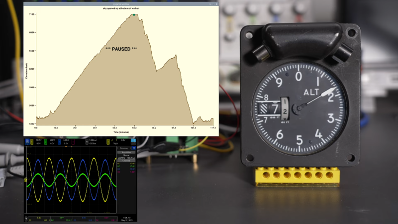
Any good bike ride should have a big climb to push your fitness, and a nice descent for the joy of careening down at high speed. [Glen Akins] has been recording his altitude during his mountain biking expeditions, and has now built a way to play them back on an aircraft altitude indicator.
A Python script is used to parse a recorded GPX file, which stores position and elevation data captured from a GPS device during [Glen]’s rides. The elevation data is then output to a Raspberry Pi Pico, which drives a set of three Microchip MCP4802 DACs and three TI OPA584 op-amps in order to create the necessary 400 Hz AC waveforms to drive the aircraft altitude indicator. One DAC and op-amp are used to generate 400 Hz AC to simply power the device, while the other two are used to generate synchro signals to actually drive the dial as needed. The maths involved is worth checking out, particularly if you’re into old-school instrumentation from the 20th century.
We’ve seen similar tinkering efforts from [Glen] before, too.
[Thanks to smellsofbikes for the tip!]


“a big climb to push your fitness”
to rapidly decrease chain life
“a nice descent for the joy of careening down at high speed”
to rapidly wear out wheel bearings
You must be fun at parties
That’s like saying: “I don’t turn my car steering wheel because it will wear out the tires”. Yes, but marinally so. Going up a hill will strain your chain but nothing that greatly decreas the life excessively, especially if well greased.
Going downhill should not have any noticeable effect on your bearings unless they are in poor condition anyway – those bearings should be able to cope with tens of revolutions per seconds putting you at automobile highway speeds.
What exactly do you think a bike is for? To sit in the corner with pristine chain and wheel bearings just to look pretty?
Hang it on the wall!
My bike rides always include big climbs: One to go over the highway, one to get out of the next road’s overpass.
Yeah, I live in the Netherlands. My commute has a total elevation difference of 10m (33ft). Highest point is 3m above sea level. Lowest is 7m below.
I’ve never liked that style of altimeter dial. I personally prefer the x100/x1000/x10000 three-hand(well, two hands and a dot) style. The digital ones are too easy to make a mistake with a quick glance.