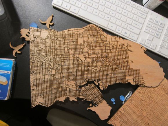
If you have access to a laser cutter you’re going to want to take a look at this brilliant tutorial. [Steven Smethurst] has figured out how to extract public map data and turn it into a file ready to be laser cut onto your choice of material.
In his example he’s using Vancouver’s Open Data Catalog to build his map using the coastal and public street data. To do this he’s using a program called TileMill which you can get for free from MapBox — it’s a great piece of software for designing your own interactive maps — and the best part is, you can import data from a wide variety of sources, such as Vancouver’s Open Data!
You can import the shape (.SHP) files from the Open Data Catalog and add them as layers into TileMill. From there you can manipulate your map, adjust the detail, and then import as a .SVG or .DXF file ready for laser cutting.
In addition to the Instructable on how to do this, he’s also recorded an in-depth video tutorial which you can check out after the break.


Which Vancouver? that does not at all resemble the Vancouver where I live in Washington State.
The one in British Columbia. That’s in South America, I think.
… it’s in Canada. Canada. Directly north of Seattle.
Phew, that was getting out of hand for a second…
Yeah, can’t decide who (if anyone) is trolling
Lovely island.
I am holding out for the 3d version that uses topo data.
Using either DEMs or writing a script to create polygons from contour data shouldn’t be too hard. Most CAD software can read DEMs so converting to *.stl is theoretically possible.
Methinks the third “import” should be “export”.
Yet another cool, but essentially useless, thing I’d love to be doing, but I can’t afford a laser, and I live in a town bereft of makerspaces… :(
If there isn’t one near you perhaps you should see if there’s interest? Starting one isn’t easy, but it’s easier than it used to be.
I’ve been wanting to do just that for quite a while. The problem is, there *was* one, but it folded. That would seem to indicate a lack of interest. I haven’t given up, though; perhaps that one was just poorly run (it folded before I had a chance to check it out).
Can you get this information for lakes too? I am trying to find a file or something I can trace of Eagle Lake in Ontario. My husbands family has had a cabin there since the 1950 and I would love to do something for them on my glowforge. Thanks for any help you can give.