We always think of [Scott Manley] as someone who knows a lot about rockets. So, if you think about it, it isn’t surprising he’s talking about GPS — after all, the system uses satellites. GPS is used in everything these days, and other forms of navigation are starting to fall by the wayside. However, the problem is that the system is vulnerable to jamming and spoofing. This is especially important if you fear GPS allowing missiles or drones to strike precise targets. But there are also plenty of opportunities for malicious acts. For example, drone light shows may be subject to GPS attacks from rival companies, and you can easily imagine worse. [Scott] talks about the issues around GPS spoofing in the video, which you can see below.
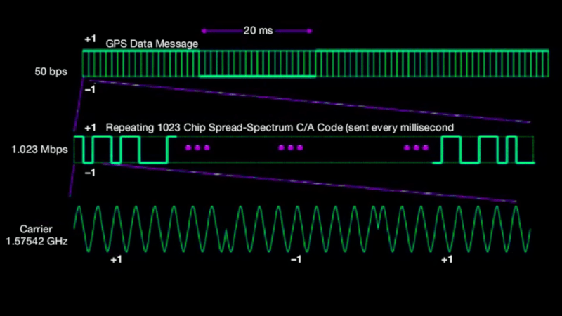
Since GPS satellites are distant, blocking the signal is almost too easy, sometimes happening inadvertently. GPS has technology to operate in the face of noise and interference, but there’s no way to prevent it entirely. Spoofing — where you produce false GPS coordinates — is much more difficult.
Of course, jamming or spoofing GPS is highly illegal, and it is easy to locate jammers, so most people doing this will be state actors and military units. Don’t try this at home. But it does happen, and [Scott] mentions how warnings appear to alert pilots of areas where GPS may be unreliable due to jamming and spoofing.
There are anti-jamming countermeasures you can employ. But things like this tend to be leapfrog situations, where jammers will overcome the countermeasures only to face better countermeasures they’ll have to overcome again later.
As you might expect, this isn’t a how-to video, but just talks about the ideas behind jamming and spoofing along with the potential countermeasures. While you usually buy a module to do GPS, you can roll your own. If you want a detailed explainer, we got you.


Spoofing to change the course of a ship was demonstrated several years ago, as a R&D proof of concept. But today GPS is used by many and very valuable, however I think we have became too reliant on it. How many of you have friends that have the GPS display on even going to the grocery store all of six blocks away?
Getting a lot of jam at the grocery store takes on new meaning.
There’s only one man that would *dare* give me the raspberry…
We’ve lost the bleeps, the sweeps, and the creeps!
That’s not all he lost.
There actually was an NPR story on this the other day. Ah, here it was in my 1440 newsletter:
Breaking Free from GPS
NPR | Staff. (Podcast) With the onset of GPS, many people are losing navigation skills—which can desensitize them to their environment. Wandering, landmarks, and storytelling are several elements that can improve one’s sense of direction. (Listen)
https://www.npr.org/transcripts/1199886119
(I was in the truck, pulling our full-time fifth wheel RV from South Dakota to Minnesota when I listened. Hah. You can BET I was using GPS, too!)
The real-time traffic data is nice even for trips where you are the expert compared to the navigation software.
Exactly. It’s not necessarily about GPS as it were, or even having POI type maps – 90+% of the time I already know where I’m going. But trip optimitization, that’s where it’s at. While I may not use nav on a trip to the grocery, I will usually use it on a 30-minute drive to work that is intimately familiar, especially on a day with a weather event that changes road conditions and causes accidents. I’ve also inadvertently tested this, as when meeting someone who navimagated with Google Maps got them to the common destination significantly faster than just driving there through the usual routes. The real reason was the whiteout storm.
And yes, there was a real art to navigating with a map back in the day, whether as co-pilot or when alone. But maps begin to work less well in areas with congestion and those are the areas where the real-time navigation optimitization is most useful.
I don’t trust google not to route me past whichever premises paid the most for their advertising. Or try to “help” by sending me past the post office because it snooped the notification that I have a package to be picked up. Or to completely shit the bed and send me to the airport because it thinks I have a flight today (I have frequently seen GMail to be wrong by 24h about flight times/dates when it tries to summarise a booking I have made)
Check my video how to build such device, it is not a rocket science https://youtu.be/sZCd-gE_p84
Last year a ferry was really spoofed in Sweden. And the point is not our every day navigation. The main usage is timing (energy, communication, banking) and Navigation in Aeoronautics and Maritime (Zivil and military)
Not to find the way to the next super market.
However, there are currently plenty of terrestrial navigation under development e.g. https://onlinelibrary.wiley.com/doi/full/10.1002/navi.450
None of my friends need a GPS to go to the store. In fact, I don’t recall ever seeing them use it for anything within the city they live except when going someplace they would’ve have gone before, like someone’s house they haven’t been to in a neighborhood they’ve never been to. Maybe it’s just your friends that need a GPS to go to a store so close to where they live? I don’t think we’re too reliant on it. That’s like saying people needed to print out the maps from MapQuest to go the grocery store a few blocks away from where they live. That’s extremely uncommon. Got to not only surround yourself with directionally challenged people 😂😂😂
More that we don’t bother turning it off to go there.
URL goes to WordPress login for hackaday
Wonder if this is what’s happening when, sometimes driving across the country, my Google Maps navigation goes nuts.
This kind of knowledge should be banned from public availability since it gives our adversaries opportunity to commit ever more henious acts of war crimes and prevents the right people from achieving victory (like it happened in 2023 counteroffensive).
Dude, the cat is long out of the bag on this one. Hiding stuff like this from the public isn’t really helpful… Russia isn’t so incompetent they rely on HAaD articles to learn how to do GPS spoofing… though they could probably learn about democracy from Yes Minister…
Yes Minister – nothing has really changed.
A bad actor with enough resources and/or motivation could easily figure this out.
This comment makes quite a few assumptions with the usage of “our adversaries” (a stance which has unfortunately become common on Hack-A-Day). It is beneficial to shed such national loyalties; beyond East versus West. We are all human beings. Both sides of any conflict commit war crimes. Anyways, interested parties need not acquire such knowledge from an over-praised YouTuber.
To some degree true, but, commonly, only one side initiate hostile actions.
wow, your bunker has internet. High class and I’m guessing it also gets all the scare channels
Never ever works. I’ve been to China recently. They have caught up with us except for the most sophisticated integrated circuits. And they’ll be there soon. They also live lives exactly like us, drive the same cars, work for the same employers, and I couldn’t really find a communist.
I was also a few feet over the line at the DMZ, in the only place you can do that legally. They hurt themselves so badly there it hardly matters what they know.
First of all, the Chinese government does deploy GPS jamming for some police actions now. As for the technology, of course they do, China manufactures most electronics and has a capitalist economy. What is your point exactly? Still stuck on cold war propaganda?
I’ve always found censorship to be the best response to anything scary or offensive. Instead of improving what we have, we can just NEVER allow any talk about how it is bad, and that is the perfect solution. Let’s make it a law that we can only talk about comfortable things.
Can it be mitigated by using gps, Galileo, glonas and beidu all at once?
Surely it would be much much harder to spoof all 4 navigation systems at the same time, by the same amount?
Yep, well not at once, but as fallback. I think most smart phones do this (combined with cellular and wifi data).
It really depends, GPS, Galileo and Beidu using very similar techniques and alarmist identical frequency (GPS and Galileo exactly the same). Flonase works directly with frequency hoping, but still with a manageable bandwidth.
So spoofing gets more complicated, but still manageable. For jamming, jamm all systems is easier then just jamming one. Anyway this satellites have laughable small signalstrength at earth, that’s why it is so easy. A lot of people pretend that you can overcome this, but in the end you can’t beat physiks.
I’ll stick to my sextant and mechanical chronometer thank you
Don’t forget the slide rule
I’ll take the EA-6B circular version.
There is a reason that I think both the Navy & Coast Guard are teaching Celestial Navigation again
Nah they stopped in the early 2000’s, plus actually doing it right requires a lot of skill. Open ocean navigation you won’t have much risk of hazards and closer to shore you can shoot synchronized visual bearing lines for a fix.
The state of BMs and QMs is such that most of them can’t really do true/desired wind or intercept/avoidance on a maneuvering board
Around 2016 they said they need to bring it back. They said they will bring merchant vessel crew because they had no one with experience left. Did it happen or how well it’s done I have no idea but apparently something is happening:
https://www.usni.org/magazines/proceedings/2021/december/bring-celestial-navigation-21st-century
I went to an Academy. The highest grade given in Cel Nav was a 76%…. Meaning the “fix” was so far off it was useless.
So sure they can bring it back, but it doesn’t mean there will be proficiency/accuracy. It’s laughable to think OCS folks will retain any of the 1 hour they would spend on it either.
Local apparent noon is still useful and practiced though.
It would be interesting to know how much cost and complexity would be involved in tacking on automated celestial navigation as a supplement to the RF-based stuff.
Obviously only applicable to systems that get a view of the sky(not a terribly demanding requirement if you’ll be mounting it on a boat; less likely to revolutionize cellphone positioning); but as machine vision problems go bright celestial objects on a black field is pretty tractable; and the math to be done once you have your measurements is well established and well behaved.
I’d mostly be interested in how much mechanical complexity you would need: would just a camera and a fisheye lens be enough if you had an accurate model of the lens distortion and(unlike a human) your algorithm can count the pixels between objects; or would you have stepper motored up sextant clicking away(or an elegant but very special order MEMS implementation of the principles of one for sextant-on-chip)?
This already exists, with dedicated tools since the astrolabe if you count manual methods and obviously far better that by eye. Aviation navigators have used increasingly automated systems ever since range warranted it and your average home telescope with a recognition system uses a low cost relative of these developments. Modern developments have it used for automatic spacecraft telemetry as well, usually with multiple trackers correlated with a gyroscope, like the ASTROgyro.
sextant use isnt rocket science, any average person can learn it, given motivation.
The SR-71 had an electromechanical sextant that could track like 7 or 9 celestial objects in real time in full daylight and put the aircraft in a 60m box. Something like that.
But then again that thing flys kinda high and clouds aren’t a problem.
Before that long range bombers used time averaging sextants as well.
So yes it’s super easy today to make a system like that. But the darn clouds don’t cooperate.
And below you’re right. 1nm error is about the usual at sea and if that does not matter hooray. But I would think close maneuvering of many ships in proximity as could occur in a battle group, at night, in foul weather makes the use case for traditional celestial navigation pretty small. Which makes me sad. Because it’s super fun and cool.
Oh yeah they are also sticking AstraIIIB sextents back in the ISS or some other spacecraft again for some reason. Either Gemini of Apollo (both?) demonstrated the use of cel nav for space craft and it was definitely deemed “good enough” for moon flights but they basically abandoned it because ground based radar was so much better and could be done, ahem, from the ground to decrease pilot workload.
So the science is mature is what I’m saying.
Sadly, the U. S. Navy stopped teaching celestial navigation in the 1990s.
1nm error at sea? Wow. It used to be pretty hard to get that accuracy on an optical bench…
As I understand it Iran used spoofing to capture a US UAV (the stealth RQ-170).
An example of a stupendously advanced technology being subverted with a common technology. I can only imagine what happened to that aircraft but I’m sure several global powers were interested.
https://en.m.wikipedia.org/wiki/Iran%E2%80%93U.S._RQ-170_incident
Russia has been fitting “Kometa” receivers that seem to be very jam resistant on glide bombs and drones. Multiple antennas are used to ignore jamming sources.
It’s a shame to see western components on devices like this.
https://mil.in.ua/en/articles/kometa-challenge-for-ukrainian-ew/
check this out https://youtu.be/sZCd-gE_p84
I wonder, does the US/UK/Etc. navy jam/spoof GPS at all when they detect a missile? I mean it would make sense if it might be GPS guided, and also if it is headed over them to a friendly target.
Like in the gulf for instance, do they jam near Yemen? Does anybody know?
I mean it would not surprise me that they do but that the western media don’t mention it.