As part of the payloads on the Firefly Blue Ghost Mission 1 (BGM1) that recently touched down on the Moon, the Lunar GNNS Receiver Experiment (LuGRE) has become the first practical demonstration of acquiring and tracking Earth orbital GNSS satellites. LuGRE consists of a weak-signal GNSS receiver, a high-gain L-band patch antenna the requisite amplification and filter circuits, designed to track a number of GPS and Galileo signals.
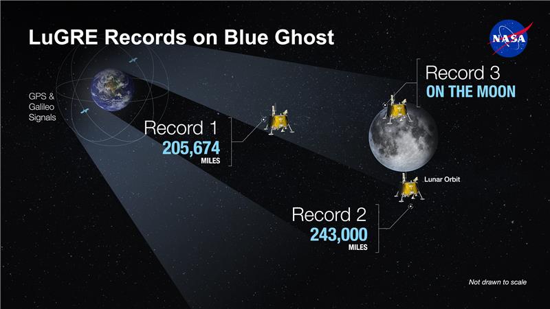
Designed by NASA and the Italian Space Agency (ISA), the LuGRE payload’s goal was to demonstrate GNSS-based positioning, navigation and timing at the Moon. This successful demonstration makes it plausible that future lunar missions, whether in orbit or on the surface, could use Earth’s GNSS satellites to navigate and position themselves with. On the way to the lunar surface, LuGRE confirmed being able to track GNSS at various distances from the Earth.
Both LuGRE and BGM1 are part of NASA’s Commercial Lunar Payload Services (CLPS) program, with BGM1 delivering a total of ten payloads to the Moon, each designed to study a different aspect of the lunar environment, as well as hardware and technologies relevant to future missions.


Shouldnt’re GPS satellites designed to beam signal only to earth? To send it it space would be waste of power because of ITAR height limits.
Wouldn’t signals from the satellites on the far side of the earth leak around the edges and then be detectable on the moon?
Yes, and I think that’s what the picture is trying to depict. It’s also worth noting that you can’t build a real antenna that only has one lobe, so at the moon you should see the back and/or side lobes of the GPS sats.
That’s pretty impressive. GNSS satellites point their antennas toward earth from an altitude of 20,000 km, so to receive signals from the moon (384,000 km), you’ll only hear GNSS satellites on the other side of the earth, and only those that are not hidden by that big ball of dirt.
Never mind just the distance and inverse-square power loss, and even bigger issue is the loss of accuracy:
At the moon you’ll only hear GNSS birds from a narrow annulus about 0.5 degrees wide, 2 degrees in diameter. That angle over which you hear satellites determines your dilution of precision (DOP). Typically on earth-bound receivers that see satellites over more than 120 degrees of sky, you typically get a DOP of around 2. Naively, to first approximation, you might expect the DOP at the Moon’s distance to be 120 degrees/2degrees)=60 times worse.
So, with a receiver that would get 10 meters position accuracy on Earth (remember, no WAAS there), you might expect 600 meters accuracy in the vicinity of the moon.
Sounds like a case to be made for a lunar navigation constellation.
But since there will be communications satellites needed, it’s likely navigation could be based on those.
With modern construction-grade GPS modules from Trimble you can expect 0,3 mm precision so on the moon it should be like 1 cm. Pretty goshdarn good if you ask me, more than enough to run moon ATV and not get lost.
That precision is only possible if you have reference receivers scattered around, and the position accuracy you get is only relative to those (relatively coarsely-known) receiver positions.
If you have the resources to put position reference devices in the area where you are going to explore, you don’t need to use satellites 400,000 km away.
Those precisions you are writing about are only possible if you either have a local reference at a known position nearby and measure the difference to that, or at least have a permanent DGPS station in the region nearby.
So such precisions wouldn’t be possible on the moon.
Maybe a lander could use some other method to determine it’s exact position on the moon and you could then use it as a local reference. But even then you are very limited by the shallow angles of reception.
That is not correct. Accuracy of sub 1cm is ON EARTH only really possible with DGPS services due to our atmosphere beeing in constant motion. However, there is no atmosphere on the moon so the signal diffraction from each satellite is about the same. Also there are no multipath errors due to trees or buildings. Additionally, you can get about 1cm precision with usage of long time statistics and precise ephemeries data even without help of DGPS. I’ve done both to get an accurate position for my own antenna location for my custom DGPS and crosschecked that with official ones. All solutions converged to a point within 1cm.
For LuGRE i was able to find 1.5km positional accuracy while in orbit at the moon at 1.6km/s so we might have to wait a bit for the accuracy when on the moon.
Garmin: you are in New Zealand, Alt: 1182192000 feet above sea level
Thought they cut out above a certain altitude because of security restrictions…
The law only requires commercial GPS to cut if it’s both above 39k feet and faster than 1000 kts. Some are programmed to cut if either is true. The law also only applies to GPS receivers built in some countries, “CoCom” is the organizing body. Notably missing from CoCom is China, so it’s not that hard to get a receiver that doesn’t apply the limits.
Well the moon is certainly both higher and faster than that at all times.. Is it really that trivial to find an unrestricted gps unit? That really blows the whole point of the security restrictions.
The restrictions were enacted when building GPS receivers was hard. Today, when you can do it with an RTL-SDR, a Raspberry Pi, and a few dollars’ worth of LNAs and filters, there’s no point left anyway.
One cool thing about the Firefly Blue Ghost mission to the moon is that it is the “RadPC”, as far as I know, very first device that uses the RISC-V ISA (Instruction Set Architecture) there. To the best of my knowledge there are no devices on the surface of the moon that use x86/x64 or the ARM ISA! Impressive for such a young ISA!
ref: https://www.theregister.com/2025/02/11/nasa_radpc_firefly_moon_mission/
WOW, imagine the HDOP of locating anything on the Moon using those signals…