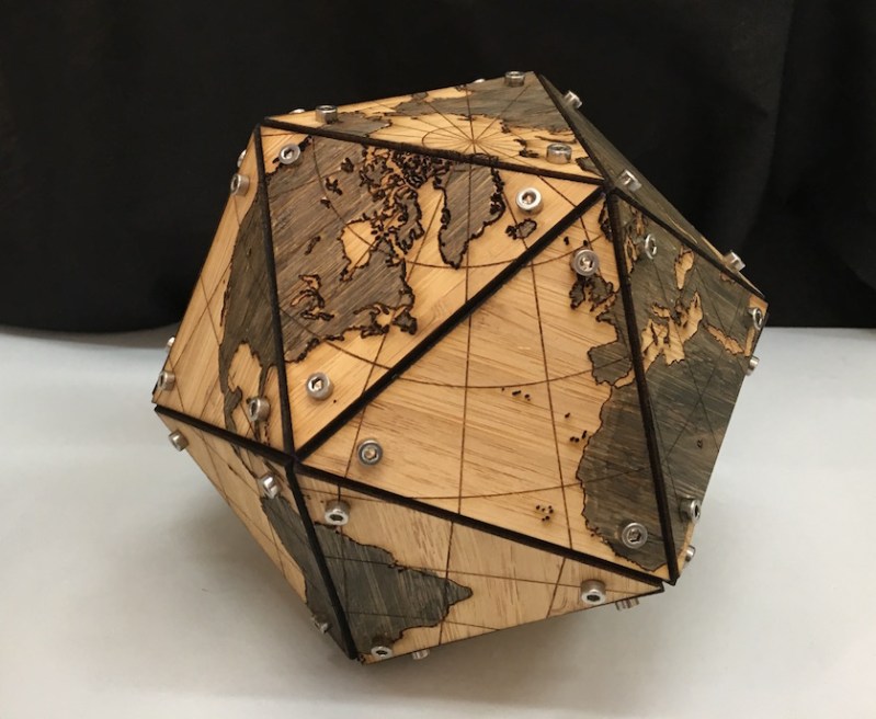
Everyone knows that globes are cool — what else would you use as the centerpiece of your library/study? But, sadly, making your own isn’t a simple process. Even if you had a large (preferably hollow) sphere to work with, you’d still have to devise a clever way of printing the map in sections that can be glued to the curved surface. Wouldn’t it be easier if you could just laser cut flat sections, and assemble them to form a faceted “globe?”
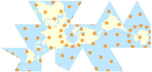
Well, it is, and you can! Because, [Gavin] over at tinkerings.org (a Hackaday favorite) has created the files to do just that! This map projection, originally designed by the very interesting Buckminster Fuller, is designed to be either laid flat or three-dimensionally on an icosahedron (a 20-sided polyhedron). That makes it perfect for laser cutting, as each of the 20 faces can be cut from flat stock.
After the faces are cut (and marked with the laser cutter), they can be assembled with 3D-printed vertices and simple machine screws. The final product is an accurate three-dimensional map that looks cool and is chock-full of interesting history and cartographic principles. Of course, if you want to up the technological ante, you could always build an interactive globe!


The poles are not centered on a face or a vertex…
… I mean you don’t even have to be ocd to find that fugly, no?
1) Minimal and uniform distortion of land mass relative size and shape.
2) Illustrates contiguous land masses.
3) Who cares about the poles? Both geographic and magnetic poles tend to wobble and wander. They’re just arbitrary points of a convenient coordinate system.
Axis of rotation is relatively fixed with respect to the earths crust, you’re going to have to make a freaking big globe before the 20 meter wandering in 100 years becomes noticeable…. https://en.wikipedia.org/wiki/Polar_motion
While meridians are arbitrary, the axis of rotation is where it is.
Are you RW’s son/beta version? This has been bothering me for a while.
WordPress has been trolling him lately.
http://hackaday.com/2016/11/22/iron-tips-soldering-headphones-and-enamel-wire/#comment-3283537
What does wibble and wobble about is the angle of the axis relative to the ecliptic. Any sign you may find saying “Here is the Arctic circle” is wrong, unless it was just calculated and planted.
Earth’s axial tilt is constantly changing, it goes back and forth, more and less angle but currently it’s moving more towards less angle than more angle.
Yes, this does have an effect on the climate, with less polar area having 24 hours to 6 months constant sunlight or darkness each year. Climate researchers have noted that in the past few decades the storm belt around Antarctica has moved further South. Well duh! The Antarctic circle has moved. Naturally the seasonal storms that build up such strength due to the uninterrupted ring of water around Antarctica, along the line of the Antarctic circle, will follow the movement of the circle. Over the next few thousand years, as the tilt decreases, those storms should weaken as they experience drag from the continent, as they always do along the Arctic circle.
Another thing to take into account is that during the southern hemisphere winter, heat can only get into the dark pole zone beyond the coastline of Antarctica by atmospheric convection. In the northern hemisphere winter heat can get into the dark zone by both atmospheric and water convection. As the axial tilt decreases, there’s less northern water inside the dark zone, so more of it gets some sunlight every day. More sun = warmer.
Having water at the north pole somewhat moderates the northern winter, while having a lot more water between the Antarctic circle and equator makes the southern winter a lot more moderate and makes the southern summer warmer than the northern summer. The oceans hold a lot more heat than does the land. That icebox called Antarctica keeps the extreme southern latitudes cooler all year, but that mostly only effects ships traveling that far south and the south tip of South America. That’s close enough to Antarctica to cause very dangerous passage for ships. There’s a submerged ridge that connects to the only part of Antarctica that reaches north of the Antarctic circle. On that peninsula, north of the circle, is where a temperature monitoring station is. That one station is often cited as “proof” that climate change is warming *all* of Antarctica.
Just as well too or NZ would be stuck in a crack… Thanks Bucky !
That is a beauty. Making one for me.
Have a look at http://www.progonos.com/furuti/MapProj/Normal/ProjPoly/Foldout/foldout.html and catch ’em all… ;-)
Haha, I get a kick out of cube Earth.
Don’t look at it too long or you’ll turn into a flat earther of the special kind…
:-P
There is another theory even weirder…
http://www.aleph.se/andart/archives/2014/02/torusearth.html
http://www.youtube.com/watch?v=yrsPHPYX0TI
That was a really fun video. Was wondering what the Moon would do. :)
Beautiful piece of work.
I’d like to see it projected onto a cubeoctahedron rather than an icosohedron though.
R. B. Fuller had a fondness for icosahedra and the projection into an icosahedron has cartographic utility.
[dgrc2015] Can you please clarify what you mean by cartographic utility?
Because of the way the projection is done and oriented on the icosahedron, two good things happen:
1) Distortion is minimized. Consider the Mercator projection we all know from school maps. Greenland just ain’t that big, no matter what it looks like.
2) When laid out flat as a map (it’s intended use, not folded into a globe) it shows the connected land masses as connected, also something not obvious from standard projections.
This admirable project takes what was intended as a flat map and folds it into an approximation of a globe. In this format it’s interesting but not as useful as an actual globe.
The utility of a sphere is hard to top, but a different method of fastening would have given a cleaner look.
D3 has a full set of variants
https://bl.ocks.org/mbostock/29cddc0006f8b98eff12e60dd08f59a7
including the airocean dymaxion from Bukminster Fuller. https://www.jasondavies.com/maps/airocean/
Hah! So the Earth is *partly* flat. Checkmate atheists!
(/s)
Speaking as someone who lives in Scotland I can’t help noticing that, according to this map, we’re screwed. :-)
Scotland is the one that always gets screwed. ;-)
I’d like to see this project held together with magnets so the layout could be changed.
Screws should be Robertsons on the Canadian face…
Most of the globe uses M3 screws that are several centimeters long, screws near the USA on the other hand…
Would make for an interesting lamp shade.
Seriously.
Immediately made me think about this one…
http://imgs.xkcd.com/comics/map_projections.png
I remember that cartoon. It made me very smug, because not only did I have a favourite map projection, it was too obscure even for Randall Monroe to have heard of it: the cordiform. I suppose what that says about me is that I am a weird obscurantist.
But the US Government knows, there is a 29 cent stamp that is the cordiform projection.
Haven’t seen that one in a while! When I was writing this, I kind of wished I had the space to go into detail about why there are different types of projections, and the pros and cons of them.
Someone went in my hackspace went through the process of this – He determined that just 20 pieces wasn’t enough and drew out his own massive map. The final product looks friggin’ amazing, here it is:
https://www.instagram.com/p/BNcbxb0jRkG/?taken-by=vanhackspace
Here’s the saga of how he got to that point (spoiler: he mostly just drew it manually):
https://talk.vanhack.ca/t/laser-cut-earth-globe/4860?u=jarrett
Beautiful piece of work. I really like your laser cutting design on wooden dymaxion globe.