The oft-quoted saying “all models are wrong, but some are useful” is a tounge-in-cheek way of saying that at some level, tools we use to predict how the world behaves will differ from reality in some measurable way. This goes well beyond the statistics classroom it is most often quoted in, too, and is especially apparent to anyone who has used a GPS mapping device of any sort. While we might think that our technological age can save us from the approximations of maps and models, there are a number of limitations with this technology that appear in sometimes surprising ways. [Kyle] has an interesting writeup about how maps can be wrong yet still be incredibly useful especially in the modern GPS-enabled world.
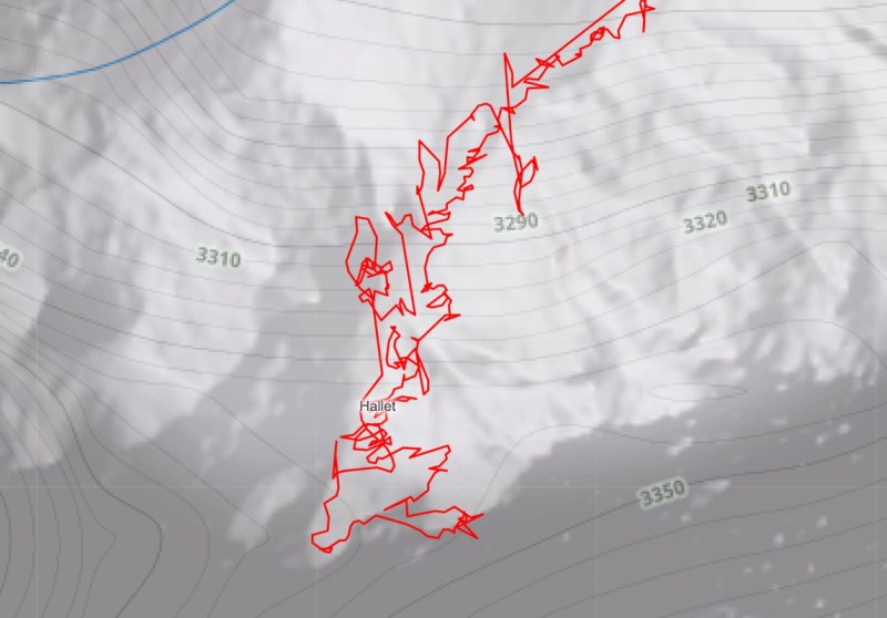
[Kyle] is coming to us with a background in outdoor travel, involving all kinds of activities like hiking and backcountry skiing. When dealing with GPS tracking under these conditions, often the user’s actual position will deviate from their recorded position by a significant margin. Obvious causes like a loss of GPS signal are one thing, but there are some other reasons for this behavior. GPS can be off by tens of meters, so the question then becomes whether or not mapping software should record these errors or attempt to guess where it thinks the most likely location is, based on available data like barometric pressure, existing trails, elevation profiles, and other data. Especially in areas where the elevation changes rapidly, these errors can compound quickly and provide some truly mystifying data. Where mapping software draws these distinctions is a matter of active debate in these communities, with some taking more approximate routes that make more sense while sacrificing the raw data, and others letting the GPS pins fall where they may.
For anyone who’s been confused by Strava or Garmin data at the end of a run, hike, or bike ride, this is a fairly informative explanation of why the GPS data might differ from the actual distance of any of these activities. [Kyle] also notes that unless you’re out with a measuring wheel (and perhaps even then) any method to determine a true distance like this will have some amount of approximation or error. The closest technological solution to a problem like this we’ve seen is this GPS receiver which claims centimeter-level precision using some unique tricks.


I’m hard pressed to think of how a recreational hike or bike ride or whatever could be impacted at all by a tracing analyzed later that is off by as much as “tens of meters.” Honestly really thinking about it, maybe lost in a blizzard? But GPS probably wouldn’t work at all in those conditions anyway.
.
I suspect it has more to do with social network (or social network in disguise) people sharing their runs or hikes or whatever .
For backcountry skiing through consequential terrain, I often use prior skiers’ GPS tracks as a starting point for routefinding (just a starting point, mind you!). Knowing whether I’m observing a smoothed/”corrected” track or raw, jittery data can help me understand whether I’m observing that the prior skier found it necessary to, say, avoid a particular couloir, go straight up the guts of a slope, etc.
These things can also be of consideration when verifying someone’s record-breaking attempt (have a look at the drama surrounding “Fastest Known Times”) — did the claimant go right down the middle, cutting off the switchbacks that are part of the route? Did they run alongside the road on the prescribed trail or, perhaps, stick to the road? Different models can give very different results, and there’s no shortage of debate about interpreting these findings.
Well started thanks. That’s a world I never knew existed.
And GNSS (don’t know which one but I use garmin so GPS+some other gnss) definitely worked in a blizzard for me (in europe) I would’ve probably made it without it as the trail was prepared with closely spaced high signage (just big sticks), but sometimes you couldn’t see one when being near the previous one.
Even in a car, tens of meters can be important. I’ve had my GPS think I missed my exit because it couldn’t tell if I was on the main highway or the frontage road. That’s not so bad, but it’s really distracting to hear “re-routing” when GPS gets confused and tries to “correct” my “mistake.”
I don’t need cm-level accuracy when driving, 1m is more than enough.
You don’t but self driving cars would probably benefit from it.
We’re already seeing talk of fitting “dumb” cars with things like speed limiters based on the imperfect science of recognising speed limit signs plus a bit of GPS augmentation, 10m could mean the difference between being on an 80mph freeway or a 30mph side-road, picking the wrong speed either way round could easily be fatal.
There are also bad assumptions made when trying to “correct” the data. When I use Google maps to track my position while on a train it tries to change my position to being on a nearby road. Not everyone travels on roads!
Why maps are lie? Because they are not 100.0000% accurate?
I would say official maps are pretty darn accurate compared to what you can get from consumer grade GPS.
As someone who’s done a bunch of hiking … Contours are never where they are claimed to be and trails are never where they are claimed to be. I have to assume things are off by 100-200m horizontally and when hiking on mountains that easily means 100-200m vertically. And that’s ignoring instances where the trail has obviously been moved.
They’re not more of a lie than consumer grade GPS, but at the same time I’ve learned they’re not less of a lie.
That sounds abysmal, but I’m spoiled by the ultra precision of mountain maps in AT/CH/DE. I have successfully navigated through thick fog with just a compass without problems because the maps are that precise.
https://en.m.wikipedia.org/wiki/Alpine_Club_map
But even mapping for the OpenStreetMap we have public LiDAR data in 1 to 5 meter ground resolution available. You can see single tracks under a closed forest canopy with that data and the map will have a matching quality, no problem.
That one time I ran into a gulley that was one contour (or one and a half?) deeper than it showed on the map, and had to walk a mile to get around it, in the desert.
There are many reasons for the real world to differ from a map. I suspect in this case it was a rainy winter or two.
When hiking mountain trails, being 1 meter off can be the difference between life and death. E.g. a 1 meter wide ledge above a 100 meter cliff.
GPS in itself is very accurate in the x-y axis. Not so much the z-axis. But the signal is reflected by all sorts of things, even your own body. So unless you run in open country with the GPS mounted on your head the signal is thwarted.
GPS does not know X, Y or X. Its just ranging, which is then projected onto an assumed flat sea-level sphere (well, to a geoid, technically). When terrain is simple – flat level ground with some static offset from sea-level, or a very gentle slope- this works fantastically, e.g. cities or wide open highways. When terrain is rugged, a basic GPS receiver becomes confused as hell because its assumption about where you could possibly be is not not valid – ‘Z’ error is also X and Y error.
Just xcheck with sat image features… using AI…
Or YOI :)… When all else fails I look at the satellite image and can often see where the path is/leads to even if Google Maps has no idea.
A friend and I used to snowboard together a lot – he had an Apple phone and I Android, we did exactly the same runs at almost exactly the same speed and used the same app.
At the end of the day the top speeds and total altitude were dramatically different. The Apple speeds were always slower. Drove him nuts :-)
I remember encountering similar issues writing software for transit buses to track, display, and announce stops and it had to track the expected route for when there were two nearby stops (imagine a shuttle bus that goes up and down the main drag such that eastbound stops are often just across the street from westbound stops) so we ended up only automatically advancing the stop if it was within some distance window of the official stop location, was later in the planned itinerary, and within some time window of the scheduled arrival. The driver could hit a button to manually advance them in the case of GPS signal loss, stops moved for emergency construction (thus not updated in the database) or an extremely late bus.
And of course even calculating what constitutes being within a 100 meter radius of a stop gets tricky both because the closer to the poles you are the fewer meters in a degree of latitude and since the earth is an oblate spheroid the amount by which this is true is somewhat moreso than were the earth a sphere…
And don’t for a moment forget that, for whatever reason, there are a plethora of folks others jamming GPS signals.
BTDT