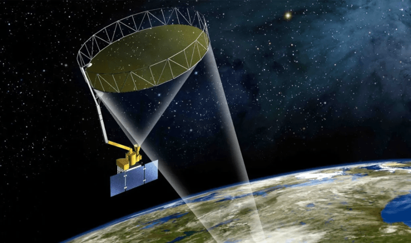
You normally think of ELINT — Electronic Intelligence — as something done in secret by shadowy three-letter agencies or the military. The term usually means gathering intelligence from signals that don’t contain speech (since that’s COMINT). But [Nukes] was looking at public data from NASA’s SMAP satellite and made an interesting discovery. Despite the satellite’s mission to measure soil moisture, it also provided data on strange happenings in the radio spectrum.
While 1.4 GHz is technically in the L-band, it is reserved (from 1.400–1.427 GHz) for specialized purposes. The frequency is critical for radio astronomy, so it is typically clear other than low-power safety critical data systems that benefit from the low potential for interference. SMAP, coincidentally, listens on 1.41 GHz and maps where there is interference.
Since there aren’t supposed to be any high-power transmitters at that frequency, you can imagine that anything showing up there is probably something unusual and interesting. In particular, it is often a signature for military jamming since nearby frequencies are often used for passive radar and to control drones. So looking at the data can give you a window on geopolitics at any given moment.
The data is out there, and a simple Python script can pull it. We imagine this is the kind of data that only a spook in a SCIF would have had just a decade or two ago.
Jamming tech is secretive but powerful. SMAP isn’t the only satellite to have its mission unexpectedly repurposed.


Interesting but the source is – let’s say – a little “odd”.
a handful of posts since Jan 2024
an empty about page: https://radioandnukes.substack.com/about
little wired distinction/separation between Crimea and Ukraine when Crimea is a part of Ukraine (possibly means nothing but I noticed it AND a commenter under the linked article felt it odd too).
Hah, sure Crimea is part of Ukraine, but uhm, how come anybody that visits it is banned from entering Ukraine ever and threatened left and right by the Ukrainian authorities? Seems contradictory.
Because to enter Crimea nowadays requires either being part of a UA military operation, or entering illegally from Russia. The former is a party a foreigner is unlike to be invited to, and the UA government really wants to discourage the latter.
Anywhere to get higher resolution maps, or is this it?
FWIW, the dog watermark on the map image looks like a recurring character in NAFO artwork. They’re a pro-Ukraine group/tribe/subculture/idunno that’s on a few social media sites, Reddit and Xitter especially. Not sure what their real-world impact is (or if they have any at all) but they are a steady source of quality satire and memes.
Also, the most appealing proposal that I have ever seen:
https://www.reddit.com/r/NAFO/comments/1jybzpr/this_is_superior_peace_plan_for_ukraine/
The magnitudes of the hotspots all seem to fall into neat categories, possibly indicating that whatever force put them up has certain levels of equipment that they send out depending on the expected level of activity that needs to be jammed.
It also seems to indicate that these systems are “dumb” in that they have no fine tuning for power level.
“Corporal, deploy the Mark 14 Jammer!”
“What power level, Sarge?”
“Turn it all the way up. We need to be invisible!”
What’s the discovery here ? And there is nothing “accidental” about providing info on radio interferences. Maps of RFI have been published for years by the SMOS, Aquarius and SMAP missions (e.g. https://salinity.oceansciences.org/smap-radiometer.htm). Space agencies have been working to mitigate illegal civilian sources using the signals measured by these instruments. SMAP was specifically designed with advanced RFI detection capabilities. Most people with interest in the science data have been accutely aware of the major flare up in RFI over Ukraine since both armies engaged in major drone countermeasures .
This is great! Anywhere to get higher resolution maps, or is this it?