Every time you watch a SpaceX livestream to see a roaring success or fireball on a barge (pick your poison), you probably see a few cubesats go up. Everytime you watch a Soyuz launch that is inexplicably on liveleak.com before anywhere else, you’re seeing a few cubesats go up. There are now hundreds of these 10 cm satellites in orbit, and SatNogs, the winner of the Hackaday Prize a two years ago, gives all these cubesats a global network of ground stations.
There is one significant problem with a global network of satellite tracking ground stations: you need to know the orbit of all these cubesats. This, as with all Low Earth Orbit deployments that do not have thrusters and rarely have attitude control, is a problem. These cubesats are tumbling through the rarefied atmosphere, leading to orbits that are unpredictable over several months.
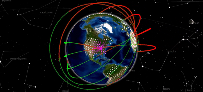
[hornig] is working on a solution to the problem of tracking hundreds of cubesats that is, simply, reverse GPS. Instead of using multiple satellites to determine a position on Earth, this system is using multiple receiving stations on Earth’s surface to determine the orbit of a satellite.
The hardware for [hornig]’s Distributed Ground Station Network is as simple as you would expect. It’s just an RTL-SDR TV tuner USB dongle, a few antennas, a GPS receiver, and a Raspberry Pi connected to the Internet. This device needs to be simple; unlike SatNogs, where single base station in the middle of nowhere can still receive data from cubesats, this system needs multiple receivers all within the view of a satellite.
The modern system of GPS satellites is one of the greatest technological achievements of all time. Not only did the US need to put highly accurate clocks in orbit, the designers of the system needed to take into account relativistic effects. Doing GPS in reverse – determining the orbit of satellites on the ground – is likewise a very impressive project, and something that is certainly a contender for this year’s Hackaday Prize.


Call it SPG, “Satellite Positioning Ground stations”.
This is already a thing
https://en.m.wikipedia.org/wiki/DORIS_(geodesy)
Thing is that positioning with any reasonable accuracy requires very precise clocks on the receiving end… So if you’re going to be using GPS (cheap and very precise clock source), you might as well put it in the cubesat…
GPS does work in orbit, only problem are the ITAR restrictions, as the satellite needs to break both of them at the same time…
Effort should go into ITAR-cancer free GPS modules being much easier to come by for non-military applications…
No???
So you want to make hardware easier to get for everyone on the planet even though it is currently on the US “International Trafficking in Arms Regulations” list, what could go wrong with that.
It’s GPS. You can buy receivers for next to nothing. You can carry mobile phones across most borders. If some evil genius wants to use them in a cruise missile, you can’t really keep it from them. The horse has long-since bolted, and China turns out millions of GPSes, the stable door is irrelevant and now just a bit of a pain in the arse for a few law-abiding geeks.
Evil DIY cruise missile huh?
Lets here, we basically copy the the infamous Nazi V1 (https://en.wikipedia.org/wiki/V-1_flying_bomb), but we use an Arduino and GPS module to guide it onto a target…since it flies significantly slower then 1000kt and lower then 60k ft… You already can use a ITAR compliant GPS for that and it should work just fine.
Warhead weight – 850kg (big boom even with crappy DIY-grade explosives)
It files much faster then most propeller-driven planes (less time to do something about it) and can carry a lot more weight then most of light aircraft that are affordable for one person to buy, yet could be made to fly very low to the ground…If made out of fiber composites, the only significant metal part would be the engine and it’s mounts, very hard to track at low altitude by ground radar…Couple that with a ADS-B jammer/fake target generator and even the military will have trouble identifying who is what.
So unless there are fighter jets already in the air, there’s a good chance this DIY cruise missile it will reach it’s target and do what you want it to.
low and behold – ITAR GPS modules are bullshit
Ah! It’s that time again is it? Time to spice up the next HAD Prize entry. I’m up for a round of Destruction & Despots.
A V-1 / “Doodlebug” is one of the best examples, and the few practical applications, of a pulse-jet. A jet engine with 1 moving part, a small valve that’s automatically actuated by the engine’s pressure cycles, just a flap really. Or if you tune the engine’s length right, 0 moving parts, you can do without the valve. One of the first jets, which makes sense considering all the high-performance stuff you need in a turbojet otherwise. A pulse-jet can just be a tube bent over half-way. They get very hot, to the point of glowing during normal operation.
But since we’re talking about metal parts, you could presumably do one in a high-tech ceramic, maybe one you could order over the Internet. Less metal, and better at coping with the heat than Hitler’s model.
Yep GPS modules have restrictions about how fast they’ll update, and are supposed to lock up if you’re travelling in a missile-like manner. But so what? Use 2, for faster updates, interleave them. And I’m pretty sure a GPS receiver uses a lot of software for that restriction, so change the software. Learning to speak Chinese would help here. Then befriend one of the manymany companies that make them. Bunnie’s “Gongkai” method of business, is how the Chinese electronics industry works. The plans and specs and source code are all there, just requires an exchange of favours.
GPS cruise missiles are 1970s technology. It’s 40 years ago. You just can’t keep technology private like that. Anyone can have it, if they really want it enough. Half the readers here could probably refine U-235 in their garage if they really wanted to. Get the ore from China or something, rig up one of those Tesla turbines for a hyper-centrifuge (as someone helpfully mentioned). If the best minds in the world did it in the 1940s, any idiot now should be able to. The Atomic Boy Scout had at least a few atoms of Plutonium in his shed, and he wasn’t even trying to do any harm.
In fact you don’t need GPS all the time anyway. Just switch it on now and then, slowing down the missile if really necessary. Once you’ve got your fix, go back to dead-reckoning with the hacked Wiimote you’re using. Or the microwave radars HAD did a tutorial on a while ago. Meanwhile you can crack old Enigma codes for a laugh, give your Playstation something to do while you make a sandwich.
I thought ITAR only restricts US exports. Can someone let me know if its possible for a non US-based (lets say European) company to produce and sell non ITAR compliant GPS receivers?
In theory yes, but in the age of international trade deals many US laws are enforced abroad. So if the company is odd any size they’ll probably get a cease and desist letter.
Just roll your own!
http://www.aholme.co.uk/GPS/Main.htm
https://people.ece.cornell.edu/land/courses/eceprojectsland/STUDENTPROJ/2009to2010/ams348/hw_gps_receiver.pdf
http://digitalcommons.usu.edu/cgi/viewcontent.cgi?article=3266&context=smallsat (specifically mentions circumventing the altitude / speed restrictions for tracking cubesats)
http://ieeexplore.ieee.org/xpl/login.jsp?tp=&arnumber=4678244&url=http%3A%2F%2Fieeexplore.ieee.org%2Fiel5%2F4677908%2F4677909%2F04678244.pdf%3Farnumber%3D4678244
Any extra weight on a cubesat = launch costs. It makes much more sense to invest once on the ground then for every launch.
It’s also quite hard to actually get to the cubesats now to install your proposed GPS update. With them being in space and all…
Doris is closer to GPS than this (doris is the ground stations transmitting so a receiver on the sattelite lets it know its own position) … this is the satellite transmitting a known signal, and the ground stations receiving and correlating the timing to determine the position of the satellite once those ground stations have shared their time-of-signal-flight information with each other. Beauty of this is no need for any hardware on the already space and power constrained cubesat – whatever signal they do transmit can have its signals time-of-flight correlated this way.
Here is an idea, HAM radio has beacons all over the world which send at precise timings to evaluate signal spreading. You could use those signals, since most already have an RF on HAM frequency receiver.
‘Precise’ is a very important word here.
Satellites are often tracked by measuring the Doppler shift. The advantage is that it requires no exact timing and it is also easy to measure with low bandwidth and average
http://www.zarya.info/Tracking/Doppler.php
I skipped most of the content of this. The only thing unpredictable of an orbit is a collision. Even that with some math, is predictable. CelesTrak, for example, releases TLE (Two Line Element) files that very very closely match the orbit of the satellite. Using this, the ground station points the antennas in the general direction. With most antennas used, the RF field is big enough to allow a fed degrees of error.
If the goal of this is to know where the satellite is, it’s a waste of time. If it is to know where the satellite is ACCURATELY, used a closed loop system to track the received signal strength of the satellite.
Orbital decay is not nearly as nicely predictable as people seem to think. Most orbital perturbations on Low Earth Orbit satellites are caused by atmospheric drag. LEO is not a perfect vacuum, and there are still many molecules of gas present. They can also be perturbed by changes in gravity. Gravity is also not homogeneous over the whole surface of the earth, so each satellite’s orbit will alter its path on the next. The moon also gets in there, tugging the satellites around occasionally. Don’t forget the moon’s orbit itself is subject to perturbations, which would need to be factored into the calculations.
These effects can certainly be measured, computed, and estimated, and are. But the lower the orbit the higher the drag, and the less accurate the predictions become over time. At some point you’ve got to take another measurement and correct your ephemeris, or risk losing the satellite entirely.
Like SatNogs, what this lacks is a truly easy to source ant affordable Az/El antenna rotor device.