Follow this train of thought: cars have sensors, cars are in frequent use over large areas, cars are the ultimate distributed sensor network for weather conditions.
Many years ago, as I wasted yet another chunk of my life sitting in the linear parking lot that was my morning commute, I mused that there had to be a way to prevent this madness. I thought: What if there was a way for the cars to tell each other where slowdowns are? This was long before smartphones, so it would have to be done the hard way. I imagined that each vehicle could have a small GPS receiver and a wireless transceiver of some sort, to send the vehicle’s current position to a central server, which would then send the aggregate speed data for each road back to the subscriber’s car. A small display would show you the hotspots and allow you to choose an alternate route. Genius! I had finally found my billion dollar idea.
Sadly, it was not to be. Seemingly days later, everyone on the planet had a GPS-equipped smartphone in his or her pocket, and the complex system I imagined was now easily implemented as software. Comically, one of the reasons I chose not to pursue my idea is that I didn’t think anyone would willingly let a company have access to their location information. Little did I know.
So it was with great interest that I read an article claiming that windshield wiper data from connected cars can be used to prevent floods. I honestly thought it was a joke at first, like something from a Monty Python sketch. But as I read through the article, I thought about that long-ago idea I had had, which amounted to a distributed sensor platform, might actually be useful for more than just detecting traffic jams.
When the Rains Come
The research was aimed at addressing a very specific problem that civil engineers and urban planners face: it’s really hard to predict where and when flash floods will occur. To do so, you need to know exactly where and how hard it’s raining, down to a very fine granularity. Fixed weather stations with rain gauges are few and far between relative to the size of most urban areas and do not provide enough spatial resolution to give a good picture of the intensity of rainfall in small areas, like those experiencing microbursts. Weather radar is good for providing wide area coverage that fills in the gaps between rain gauges to some extent, but it suffers from resolution problems as well. The idea here was to correlate historical windshield wiper use in a fleet of instrumented vehicles with weather radar archives and fixed rain gauge readings of past storms, to see if data on wiper use can augment traditional rainfall measurements.
Filling in the Gaps
Perhaps unsurprisingly, they found that drivers tend to turn their wipers on when it rains, and the harder it rains, the faster the wipers are set. But the more important finding was that by subjecting the windshield wiper data and weather radar data to a Bayesian filtering network, the weather radar could be updated to locate areas where it was actually raining but that the radar missed, and to find “holes” in the rainfall pattern where the radar insisted it was raining.
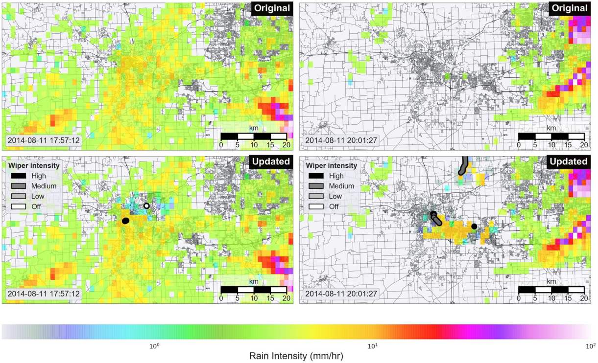
These updates were by no means small, spot showers; the updated areas that the radar misinterpreted were on the order of 10 km across. Given the size of some local watersheds, especially in urban areas, the assessment of “raining” and “not raining” over such an area could make the difference in accurately predicting a flash flood.
Despite the somewhat ambitious article, this study only lays the basis for a future in which connected vehicles can be used as remote mobile sensing platforms. One can imagine not only getting high-resolution rainfall data but also localized reports of temperature from exterior thermometers and assessment of road conditions from anti-lock brake and traction control system data.
There are huge hurdles between where we are now and the day that an urban planner can get high-resolution spatial and temporal data from vast numbers of connected vehicles plying their streets. But where there’s a wealth of data to be mined, you can bet your bottom dollar that someone has a plan to exploit it. The degree to which that benefits those that generate the data remains to be seen, but for now, it’s pretty cool to know that windshield wipers can, sort of, be used to predict flash floods.


Privacy! Privacy! Privacy!
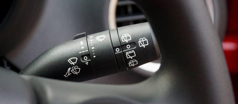
“The man” doesn’t need to know when or how I use my wipers!
It’s more that it’ll open the floodgates for the privacy invading cousin of feature creep.
We’ve all seen it happen with current tech gigacorporations, let’s not repeat our mistakes out of insanity.
“Big Brother” figures you voluntarily give up the right to keep your wiper use private when you drive on public roads in the rain.
In order to make the information useful, they also need to track the vehicle by GPS.
And since GPS can be unreliable, they need to keep some history about where the vehicle has been in order to filter out erroneous results.
And while we’re at it, now that there’s a database of where everyone is and has been for the past few minutes, we might as well use it for speed control enforcement, road toll tracking, live mileage taxing, insurance premium calculating, cheating husband catching…
^ What Luke said
+10 – as mentioned in the chain – this is worthless without your vehicle also providing GPS updates, and if you’re providing GPS of your car to a third party, they’re only a calculation away from auto speeding citations and any other form of tracking / marketing / etc.
– Also amusing – Hmmm, augmented weather seems to be scattered showers suddenly on a clear day? – Or is it just a nice day when many are out washing their cars tripping moisture sensors? (mostly kidding, since vehicle may need to be on to be reporting, but since system could be more accurate including parked/off cars, not necessarily… – many ‘fancy’ cars already have auto-activating wipers, so sensors could be polled rather than actual wiper status…)
Build it into a weather app running on the car’s infotainment system and millions of people will willingly (or unknowlingly) provide the data.
A windshield wiper more accurate than a rain gauge?
You gotta be kidding.
Also from the same site, Japan predicts the douwnpours half an hour before they occur:
https://techxplore.com/news/2019-02-japan-downpour-tokyo.html
A long time ago Donald Duck got some special stuff from Gyro Gearloose and he could shape clouds for farmers.
He was so good at it that the raindrops that fel on the fence had a flat side.
I was once very impressed by that.
No, a windshield wiper isn’t more accurate than a fixed rain gauge. That’s completely missing the point. The point is that a mobile sensor platform that can detect whether it’s raining or not along with its current location can provide a finer grained picture of the actual spatial and temporal distribution of precipitation within a storm. The idea is not to quantitate the rainfall to the nearest 0.01″, it’s to see if the wiper data can fill in the gaps in fixed station gauges and radar estimates.
Doppler radars can see rain much better than tracking everyone’s vehicles just to see if their wipers are on.
They specifically show two radar maps before and after using wiper data to correct it. Where’s your proof its more accurate without the wiper data?
It’s just TV-shop “before/after” comparison made to sell the idea.
Doppler radars cover very large areas, and adding a single radar would improve the measurement resolution more than adding a thousand spot samples (cars).
Furthermore, since cars run their wipers for many reasons (washing up dirt/spray) and they’re stopping and moving constantly (speed affects rate of rainfall on the windshield, or whether you’re tailgating another car and there’s water on the street), and GPS can jump around randomly, the data you have needs to be averaged over many cars to filter out spurious results – otherwise you’re just adding noise to your radar image and pretending it’s information. It may look like you’re adding detail, but what you actually have is a dither that represents very low-resolution data that is not actually adding much more information to the radar image.
And most US states don’t even have one. Our state (Connecticut) only has one allegedly, and it belongs to our largest TV station. If you know our state, we are full of trees, hills (small mountains), and valleys. Wiper blade data can fill in those gaps, ostensibly .Our Doppler radar station is on top of a mountain in north central CT. I have been in many radar (or radio) dead spots in a low-lying valley blocked by surrounding mountains and plenty of deep forest. And if a river flows through it? Well that’s a prime flash flood area. You can still transmit wiper data from there by wi-fi hot spots’s and/or 3/4G connection, if a cell tower is on one of those hills. In a mesh network, the wiper data could be stored and forwarded until Internet visibility is prime for your car.
Would the more obvious solution then be to build one doppler radar, rather than assume everyone will get a GPS tracker installed in their cars?
Surely it would come cheaper. Oh, but then you don’t get to track where people are driving, and you don’t get to apply the fancy buzzwords “big data”.
Quote:
They found that tracking windshield wiper activity can provide faster, more accurate rainfall data than radar and rain gauge systems we currently have in place.
Source: https://techxplore.com/news/2019-01-vehicles-windshield-wipers.html
To me that reads more like they have a particularly bad or outdated weahter radar at that location.
Just an overengineered solution looking for a problem. Wheather radar where I live has a resolution of about 1km or better and accurate tracking of even light drizzles. I can see on the ‘net in which direction the wind is blowing and when the rain is going to hit my window.
Combine that with the Japan article and 3D scanning of storm coulds each minute and the article above becomes obsolete.
Typo in 1st sentence: “cars are infrequent use”. I’m almost sure you meant “cars are in frequent use”.
FTFY. Thanks
ODBC data? I think you mean OBD?
This reminds me of something else I think is in use now in India. And it does not require opt-in to protect privacy. Here in USA we have several fleets of connected vehicles with dash cams and mobile connectivity. We have the local L.E.O. fleets, US Postal Service, etc. In India they use the postal fleet to allow rural people to have a quasi-SMS linked system based on the Mesh Net model. Like a popular Ham radio digital repeater technique ( I can’t remember right now.) Its like a mini digital repeater in each vehicle that pings off every close by vehicle that is mobile. The end-user sends a text message and a available close-by vehicle picks it up,. It holds onto it until hand off to another vehicle, all this until a vehicle sees the Internet and then transmits it to the desired recipient. And then replies follow a reverse method.
For this scenario, the weather sensors (and GPS) coupled with the dash cam feed could be fed into a meshnet node in the vehicle.. The data is compressed then transmitted to the weather central. The mobile system looks for open wi-fi access points or any other meshnet node to handle the uploaded message. Monochromatic video can be reduced to a low bandwidth method that can be carried on standard audio and just a little better than SSTV (I forget the name of it – it is old technique video over audio too).. Also the wiper’s movement could be detected by the dash cam as it is directly in the wiper’s path. The existing LEO’s dash cam could be used or the operation could supply one as the price points are low for them now.
At weather central system could deploy an A.I. program to analyze all the incoming data with GPS data and supply a “big picture” of local weather. The data could be allowed free to the participating LEO or USPS organization(s) to pay for the use of their fleet vehicles. An unrelated model is being exploited with airlines now in where airlines are allowing their planes to be high altitude wi-fi hot spots or cell phone access points for ground end-users. (I’d love to see this done with pay-per-view live high altitude aerial surveillance feeds like a live DoD satellite feed).
Sorry for rambling…
Does the USPS have dash cams in their vehicles? I’ve never seen one in my area. In fact I was just chatting up our mail carrier the other day at the door of her truck and I was amazed at how spartan the interiors are on those things. I’d be surprised if they even had wipers TBH.
But I see where you’re going with the idea – make a mesh network from a fleet of vehicles already roaming the streets. Trouble is, wouldn’t the network go away once the vehicles are off the streets for the day?
Police, fire etc are always in constant use why not get the data from that, most of those vehicles are connected anyway so what is one more tiny sensor?
Government and business vehicles don’t open up the same privacy issues as private, so this idea can be tried without causing the same problems.
Ostracus – Except with Uber and Lyft drivers in where the private vs public vehicle line is blurred a bit.
Newer USPS truck models will likely have dash cams and gps. They wouldn’t waste the money retrofitting the old ones.
They barely spend money repairing the old ones.
Dan Maloney – No USPS trucks don’t have dash cams. FedEx trucks due have Internet connected hand scanners though. And I think they GPS track FedEx trucks. However using a USPS truck the inventor would have to supply cheap web cams.And yes they do have at least one wiper over the driver side only (on the right side). And yes USPS stops fleet running at night. However LEO is 7 x 24. And ubiquitous. Hey I’m just brainstorming here. Someone else will need to beat out the wrinkles in my random musings. :-)
Oh I forgot Uber and Lyft drivers. Ever watched the live GPS display of Uber wolf packs looking for fares? It goes all night long and even in rural communities. Don’t forget traditional taxicabs too. Another source of input is highway semi trucks.(owned by logistic companies). They are always out there steaming along in rainstorms across country up and down our highways in USA. However, most of these companies do use dash cams, but they are aimed the wrong way to pick up cabin incidents (like in Uber cars). But a lot of people like the cheap Walmart-available dash cams to catch the often careless fender bender but its only loop recording and not Internet connected. The inventor would have to suply their own IoT web cam and GPS tracking.
USPS buys the lowest cost vehicle they can. Heck in the country rural mail carriers, which despite popular belief is the majority of America, use random vehicles that are like drivers ed cars with the steering wheel relocated by a belt system.
Instead of trying to create a mesh network where all of the data points are mobile, why not invest in placing automated weather stations on cell towers? These have the advantage of being wide-spread but placed close enough together to get meaningful data, stationary so that tracking data is not required, a local stable data connection, and the data gathered would be much more precise than ‘the speed of someone’s windshield wiper’. That would also provide wind speed and direction, which is something a mesh network from vehicles could not do.
Good idea Mike but this is Dan Maloney’s idea not mine. Dan’s idea as well as my suggestion can not supply wind speed and direction just as you say as the motor vehicle is moving. Cell towers are maintained by very territorial (and paranoid) companies. They are not conducive to adding anything unrelated to their towers. They don’t want any EMI/RF interference sources, electronic surveillance of private cell calls, nor insurance liabilities. many are in very remote places too. But your idea has merit. However, how much more cooperation could you get from a basic homeowner volunteering their rooftop to the project?
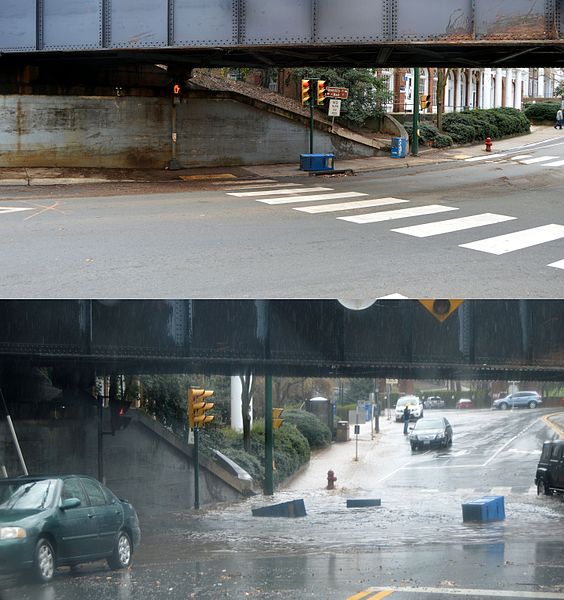
Oh, man, I still have PTSD from that storm shown in those maps above. I *was* paying attention to google traffic and the weather radar, but I narrowly missed getting stuck on I-696 when its drainage pumps failed, only to find myself on a very dark residential street (due to power outage), with rapidly rising water. I escaped by driving on the front lawns and sidewalks (sorry for the tread marks folks!), with the bow wave splashing over my car hood. I’m lucky the engine kept running and I didn’t hit a fire hydrant or something, and made it to higher ground. It took me six hours to make it out of there, and that poor engine was never quite the same after that. I junked that car four months later. Puddles give me nightmares now.
I often think back about what information would have been helpful, had I had access to it, and I honestly think even street-by-street real-time data on traffic and water level would NOT have been more helpful. Events evolved so quickly and unpredictably that even very good local status reports would not have made a difference in the outcome.
Android Auto’s T&C’s allow it to copy any and all vehicle data from OBD2, CAN, and any other bus. I can only assume Apple Carplay has similar terms. Amazon announced that Alexa will be installed in a lot of new cars as well. Also, Microsoft has had a long partnership with Ford as an infotainment producer. As more cars get updated stereos and telematics, privacy will be harder to come by. I almost forgot, Geico and other insurance providers have OBD2 trackers that “allow” lower rates for safe driving.
https://en.wikipedia.org/wiki/Vehicle-to-everything
There are lots of tests currently underway across the nation. There is quite a lot of research being done in collision avoidance V2V and V2P (vehicle to vehicle and vehicle to person). And not that there is a standard and allocated spectrum, all vehicles will be equiped to at least report their position to the network. One of the largest such projects (also weather related) is the Colorado DOT project along the I-70 corridor to monitor traffic and weather conditions in real-time:
https://www.codot.gov/news/2018/july/cdot-and-panasonic-take-first-steps-to-turn-i-70-into-connected-roadway
HONEYWELL SEES CONNECTED RADAR ON THE HORIZON (2016)
https://aerospace.honeywell.com/en/news-listing/2016/july/honeywell-sees-connected-radar-on-the-horizon
In the town I live in there’s an unnecessary traffic jam every other weekend caused by automatic rerouting: On weekends with a lot of touristic traffic towards the south, the autobahn that leads around our and other towns starts to get jammed, which is annoying but ok, it’s a hard problem. New and terrible is the fact that since about two years, the traffic gets automagically distributed by navigation systems based on traffic mass data to all the streets available, resulting in the unneccesary blockage of the whole area. Everybody is frustrated: the people living here, the people in the cars, the kids, the cats , the dogs.
Honestly, as fascinating as the field of mass data is, I feel like it’s hardly ever fulfilling its fulminant promisses as it often promises optimization where there’s simply nothing to gain or only at hidden costs nobody wants to pay.
Mass Data by Nokia as a means of keeping the maps autonomous vehicles need current, and accurate.
The theory of “Induced Demand” seems to be at play there.
Increasing the number of roads increases traffic.
https://en.wikipedia.org/wiki/Induced_demand
We are winding down a dangerous road here. pun intended.