The Global Positioning System (GPS) is so ingrained into our modern life that it’s easy to forget the system was created for, and is still operated by, the United States military. While there are competing technologies, such as GLONASS and Galileo, they are still operated by the governments of their respective countries. So what do you do if you want to know your position on the globe without relying on any government-operated infrastructure?
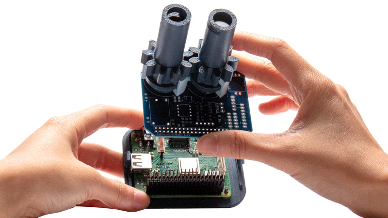
According to the team behind [Aweigh], all you have to do is take a cue from ancient mariners and insects and look up. Using two light polarization sensors, a compass, and a bit of math, their device can calculate your latitude and longitude by looking at the daytime sky. With their custom Raspberry Pi shield and open source Python 3 software, the team envisions a future where fully-independent global positioning can be tacked onto all sorts of projects.
The concept relies on the Rayleigh model, which is essentially a polarization map of the sky. As light from the sun is scattered in the Earth’s atmosphere, it creates bands of polarization which can be identified from the ground. Essentially it’s the same principle that makes the sky appear blue when viewed with human eyes, but if you have two light sensors looking at the proper wavelengths, you can use the effect to figure out where the sun is; which the team says is precisely how some insects navigate. Once the position of the sun is known, [Aweigh] operates like a modernized, automatic, sextant.
Naturally, this is not an ideal solution in all possible situations. In an urban environment, a clear view of the sky isn’t always possible, and of course the system won’t work at all once the sun goes down. In theory you could switch over to navigating by stars at night, but then you run into the same problems in urban areas. Still, it’s a fascinating project and one that we’re eager to see develop further.
Incidentally, we’ve seen automated sextants before, if you’re looking for a similar solution that still retains that Horatio Hornblower vibe.


Avoiding dependence on external infrastructure is a very wise move. What’s the positional accuracy like or is that not yet predicted/tested?
Don’t you need exact time? Ships couldn’t navigate properly because they couldn’t find longitude without accurate time. A campaign to encourage a portable chronometer was offered, and onky when someone built one tbat kept time could mariners find longitude.
Of course, one way today of getting accurate time is via GPS.
The old methods still work as long as you have time. Books wikk often warn people to not rely on GPS, in case the batteries run out or something fails.
Michael
Everyone with a modern phone, even the cheapest burner, is already carrying a portable chronometer of excellent quality.
The design includes a RTC set to GMT. That would provide the time to some accuracy.
Absolutely. There’s an RTC module on the board to make up for the fact the Pi doesn’t have one, and as long as you have Internet connectivity getting it synced to NTP shouldn’t be a problem. If all else fails, presumably the user can also enter it in manually and deal with the hit to positional accuracy.
My point n bringing up time is because a few years back I bought a used copy of “Longitude”, which was like a long essay about the need for chronometers. More about navigation than I actually need, it was an interesting book and dealt with the creation of a chronometer. It had to keep proper time, and not run down too fast, and small and cheap enough to put on ships.
It was the sort of book I would never have sought out, but finding it among a table at a used book sale it jumped out, and unlike many books, I read it soon after I.brought it home. It didn’t talk down, but neither was it overly technical.
Michael
It was also a mini-series starring Jeremy Irons
IIRC, the Vikings could tell, on an overcast day, the direction of the Sun (or North) by looking straight up, Some people can see N-S lines doing so. (inferometry?)
Viewing the sky that way, but through a type of crystal, also does it.
Oh, a quick search turned up this…
https://www.newscientist.com/article/dn20052-vikings-crystal-clear-method-of-navigation/
They (may have) used a calcite crystal, which also uses polarization. https://www.sciencemag.org/news/2011/11/viking-sunstone-revealed
If you have access to all 4 positioning systems: GPS, GLONASS, Galileo and BeiDou, chances are that one or more of them would still be functional. If not that means you have something far worst than getting lost i.e. big solar flare knock out all satellites, Kessler syndrome, EMP from WWIII etc
At no level of badness of situation should one give up trying to improve it. If I am lost and on top of that the world has a big problem, none is coming to my rescue but myself.
This project is (using the words of a famous but fictional traveler) “fascinating”.
Due to my own ignorance I was not aware of this effect, so thanks for enlightening me.
Cool project!