I’m writing from a cozy farmhouse just outside of Oxford, UK where we are slowly emerging from a particularly intense Atlantic storm. Some areas have widespread flooding, while fallen tree branches and damaged roofs are countrywide. Our neighbours in the Irish Republic are first in the path of these storms, and receive an especially strong pasting.
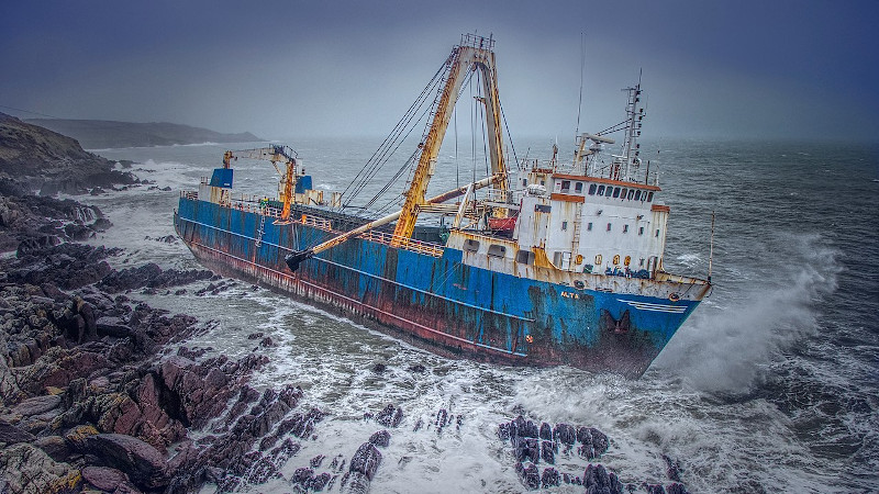
In the news following the storm is a merchant ship that was washed up by this storm on the coast of County Cork. The MV Alta is a nearly 2300t and 77m (just over 253 ft) freighter that had been abandoned in 2018 south of Bermuda after a mechanical failure had rendered it incapable of navigation. Its crew had been rescued by the US Coast Guard, and since then — apart from a brief sighting in mid-Atlantic by a Royal Navy polar research vessel — it had passed unseen as a drifting ghost ship before appearing on the Irish coast.
In a very literal sense it had dropped off the radar, but the question for us is how? With the huge array of technological advances in both navigation aids and global sensing available at the end of the 21st century’s second decade, should that even be possible? It’s worth taking a while as land-lubbers to look at how ships are tracked, to try to make sense of the seeming invisibility of something that is after all pretty large and difficult to hide.
One Of These Maps Is Not Like The Other

Greenland for example is many times smaller than its depiction in a Mercator projection, and the distance across the far north Atlantic from Greenland to Norway appears as the same as that from for example New York to Morocco. In reality the former is in the region of 1000 miles while the latter is over 3500 miles. As a comparison the road distance between New York and San Francisco is about 2900 miles.
The Atlantic, It’s Bigger Than You Imagine
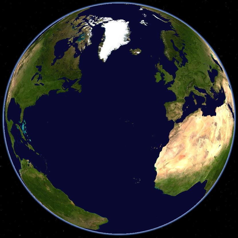
In that light It’s easy to believe that the captain of a ship such as the Alta could plot a course that would keep it away from other craft and effectively disappear from view in a space that vast. It’s not impossible that without a captain and with its AIS transponder out of action it could also drift unseen through the same space.
You Won’t Find It Unless You Go Looking For It
![One of the US Navy's venerable Lockheed P-3 maritime patrol aircraft. US Navy [Public domain]](https://hackaday.com/wp-content/uploads/2020/02/1024px-Orion.usnavy.750pix.jpg)
They may have radar-equipped maritime patrol aircraft in the sky, undersea hydrophones, and satellite monitoring overhead, but all of those things require naval intelligence to direct them towards a vessel of interest. If intelligence indicates a potentially hostile ship has left port, then a formidable array of machinery and technology will shadow its every move. But the Alta, floating rudderless with no one aboard, hardly fits the bill as a threat to global security. Indeed it could have evaded some of those systems anyway, as without the engine or wake of a ship under power to detect, they simply wouldn’t have found it.
We hope the Alta will not cause a headache to the Irish authorities and that perhaps a few extra tourists come and spend their Euros in the area when they come to see it, but if its fate tells us anything it is this: We sometimes like to believe that we are the masters of our world, when in fact over so much of its surface we are still as at the whim of nature as our ancestors were centuries ago when they crossed oceans in tiny wooden craft.
MV Alta header image: Colm Ryan / CC BY-SA 4.0


I’d imagine it popped up on the edge of a dozen commercial radars, but without identifying it, getting within visual range to ID it from color scheme and silhouette if they could even be bothered to look that up, then it would have passed unremarked.
I’d also imagine that it was detected by plenty of assets that various militaries didn’t want to expose, if it hadn’t made the last dash on a storm, some patrol vessel would have “found” it when it got close to the coast, vectored there by other intelligence. Had lost people been involved still, it might have been “found” earlier due to aircraft being sent to search in the area they knew it was.
It’s like the missing person found 20 years later working as a fry cook in the next state/county… it wasn’t that nobody at all saw him for 20 years, it was that none of the 1000s of people that saw him realized that he was being looked for.
https://www.youtube.com/watch?v=6zkZ3f8DnKs
:o)
Bah. https://www.youtube.com/watch?v=tRZx6ChTMQ0 ;-)
Actually the major powers probably where tracking it. It would have been detected by ocean surveillance satellites. After that it was probably imaged it or a patrol aircraft checked it out. After that it was probably makes and uninteresting. It was not reported because there was no need to from a military point of view as it is not dangerous.
I was told that satellites look for a ship’s wake, and that this ship would have had no wake. But I am but a land-lubber.
And. Absent a good reason, they have no call to expose their abilities.
There’s still the drug smuggling trade. Doesn’t always have to be a military button pushed. Never mind the “immigrating from via sea…” thing which was all the news when we still hated Cuba. And of course everyone’s favorite, terrorist, terrorists, terrorists. Rhymes with “won’t someone think of the children”.
Right, the Garda with their 100 mile over the horizon drug radar should have seen it. It’s possible given the history of the entire island that segments in the Eire establishment made sure that they didn’t have a system for alerting clandestine landings, given that’s how elements in the North were thought to get most of their armaments.
Also magnetometers and similar sensors can detect anomalies in the magnetic field induced either by the Earth one or big metallic masses in vicinity. I’m totally sure the military had this ship position on a map since day one.
My very serious question is do all hackaday writers use only one space between a period and the beginning of a sentence. This is the second article I’ve seen to be this way.
Just for you I put 7 spaces between the first 4 words, see them?
This comment board is fairly barebones and primitive. HTML treats one space ” ” as one space, two spaces ” ” as two spaces precisely to address the two spaces after a period issue, and more than two spaces ” ” as two spaces.
I doubt the wordpress software does it.
My major point is that it’s a complaint that’s a quarter of a century too late on the web. NYT, WP, Reuters, AP, ain’t nobody got 2 spaces after their full stops.
Dave M, you must be around my age. I still do two spaces because I was taught that way, but current practice is now a single space.
Culture changes. I try not to get worked up about it.
It’s been a single space for the last 25 years because the amount of whitespace between sentences is determined by the layout software, not by the number of space characters. Using two space characters instead of one would not make any difference.
Like you, I learned to type on a mechanical typewriter where we made our own layout decisions and it was correct to hit the spacebar twice between sentences. It’s time to join the 21st century.
Let our digital assistants type it all out for us.
Could be a cultural thing? The author is from the UK, as am I, and I’ve never put more than one space after a …errr… full stop. I didn’t even know it was a thing.
Yes. It is. We do the one space thing.
Could be a cultural thing from US ? Never heard of it either from France.
Also not in the Netherlands. It always has been one space for me.
Even during my typewriter lessons… 8-)
When I learned to type, it was on an IBM Selectric II. For formal business letters in Olde Days, it mattered. But this is 2020, and double spacing hasn’t mattered since about the Clinton administration. It’s fallen out of use because on a computer, it’s a waste of screen space. It isn’t strictly required and furthermore. I can double space my sentences as I have these last two, and it’s doubtful that anybody would notice whether I did or not. Culture changes, and language (and its written form) with it.
https://en.wikipedia.org/wiki/History_of_sentence_spacing
Oops, since this isn’t my post I can’t delete the above, but hopefully someone will (and this one, too)
Isn’t that typical of a HaD writer? “That post displeases me!!! It must be deleted!!!”
Well it is my post I want deleted;)
Clinton? Maybe in the US, but not since Thatcher in the U.K.
Back then our Mac handled spacing automatically.
Indeed, my comment reflects my own experience :)
Good article.
I see the local authorities have airlifted around 80 barrels of waste diesel and hydraulic oil off the ship, so there should be no major environmental impact – that is, if you don’t mind an 80 metre cargo ship ruining your coastline.
Journalists and typing tutors often demanded two spaces between sentences. The former, because they would hand their hard copy to an editor, who would mark corrections before handing it to typesetting who needed to know clearly where the breaks were. Tutors taught their students this method when typewriters were manual and a lot of people learned to type this way as a result.
Except for articles written on manual mechanical typewriters, where the nature of the beast employs mono-spaced letters, one space between full-stop / period is all that is required. Even when books were typeset with metal letters, they were set with proportional width — the letter ‘I’ for instance didn’t need to be as wide as ‘W’. A good article about it can be found at https://www.theatlantic.com/technology/archive/2011/01/why-you-should-never-ever-use-two-spaces-between-sentences/69579/
There have been typewriters able to do proportional spacing. That’s what caught out the people who created the fake AWOL documents on GW Bush. They used a proportional font, but IIRC the military office where such letters were typed didn’t have such fancy pants typewriters, though they existed at the time.
It’s afaik an American thing to do two spaces. I’m a Brit.
I had my writing honed by working for the Oxford Dictionaries for years, and I never encountered the two-space style there either.
american english teachers love to teach practices that are in fact not part of the english language. i think it has more to do with papers being easier for the teachers to read and grade and have room to pencil in corrections, and its pushed to a degree where it becomes a mortal sin to do otherwise, you can even receive a reduction in grade if you don’t do it.
Well no – You’d fill the extra space with an alphanumeric, punctuation, or comma.
I agree about this being a Brit v US thing. I took a touch typing course in the early 70s and we were taught one space after a full stop (period!). It’s interesting that this sort of thing hasn’t got into the settings on word processors.
I was taught two spaces here in Ireland, but that going back some 25 years.
Wadda ya want? 28 days between periods!?
That’s long been abandoned in every style guide for writing. But you should always use the “Oxford Comma”. A company lost their case against paying some workers overtime because they left it out in the contract. https://www.usatoday.com/story/money/2018/02/08/oxford-comma-lawsuit/320944002/
Yes. This.
Fun fact, there is a real Oxford Comma. It’s printed on a piece of parchment and framed, on the desk of a former colleague of mine at OUP.
My very serious question is: where is the question mark at the end of your question? And you’re questioning the punctuation of others?
And another thing, you should never start a sentence with and…
Yes.
Why should they? One space is normally considered correct on ANY proportionally spaced font (And this article is made up in a proportionally spaced font).
In actual fact, two spaces after any end of sentence punctuation mark is a holdover from the days of monospaced fonts/typewriters and is often actually seen as being as archaic as, well, a typewriter.
(https://www.writersdigest.com/online-editor/how-many-spaces-after-a-period)
WHAT???? This is no spelling or grammar blog, it’s a technical thing here. Your comment is completely irrelevant! You distract my attention for NOTHING!
Oh, let’s see. TeX, Markdown, RUNOFF, nroff, troff, groff, SGML, HTML, XML… I’d say we have a lot of typography and formatting nerds here.
One space has been the standard and the rule ever since variable-width (or, proportional) fonts mostly replaced monospace fonts. Monospace fonts were designed to emulate the typewriter letters they were replacing. Two spaces were needed when every character, including the space, were the same width. Proportional fonts dynamically adjust the spacing after a period. That’s been the rule since the 90s, so if you’ve been using two spaces you’ve probably been doing it wrong (unless you’re still using monospaced fonts, which is unlikely). Monospace fonts are still popular among some people who use them intentionally, like proofreaders and editors, but most of us use proportional fonts without realizing it.
Yes, our style is to use one space before the beginning of a sentence. Multiply the number of sentences in an article by 8-11 articles per day by hundreds of thousands of readers per day… what a bandwidth drain for a redundant space!
:-D
I find myself wondering why the ship wasn’t towed into port immediately after the rescue. I can’t imagine anyone looking at an asset worth millions of (insert currency of choice) being abandoned for no good reason, especially since it has the capacity to become an environmental hazard due to various substances present on ships like that (fuels, oils, cleaners, etc.).
Towing a large ship is very risky and very expensive. And in many countries, scrapping ship that large actually costs money, Why pour that much money into such an old, worn out vessel?
i’m not an expert buy i would venture a guess that economics play a big role. if towing and repair are worth more then an aging ship and the future prospect of income from hat ship is limited before it has to be scrapped anyway it might not be worth the salvage. i fully agree on the environmental hazard but i guess big company don’t care so much about that.
And presumably it’s insured with Lloyd’s (isn’t that traditional for ships?) so there’s no loss if they write it off.
Depends on how it was insured, its possible it has lapsed. They couldn’t remove the vessel for a number of reasons, whether its going to cause an environmental impact (leaking oil etc.) its structural integrity (is it likely to fall apart once its towed from the rocks) etc. hence why they sent surveyors to check it first.
Seems to be a bit more to the story…
https://www.maritimebulletin.net/2019/09/04/12702/
But still not finding specifics of USCG rescue. Typically, they won’t attempt to get a tow cable on if the weather is too bad, and they’ll tell you “We’re only coming once” so if you don’t go then, you’re going down with it if it overturns due to not being able to keep head into weather or hitting a rock etc.
There is an even weirder aspect to the story. It was taken in tow, but after reaching a port it was hijacked! What happened to the hijackers?
Which is not confirmed by anyone except the owner, who probably saved money by this inconvenience. I.e. I think the hijack story is made up and the vessel was never towed to begin with.
I feel there was a missed opportunity here to slip in this quote or a lede for a future article about asteroid hunting…
Space is big. Really big. You just won’t believe how vastly, hugely, mind-bogglingly big it is. I mean, you may think it’s a long way down the road to the chemist, but that’s just peanuts to space. – Douglas Adams, The Hitchhiker’s Guide to the Galaxy.
Don’t believe I wasn’t tempted.
This made me think of another quote:
“The universe is a pretty big place. If it’s just us, seems like an awful waste of space.”
― Carl Sagan, Contact
A nitpick: “Viewing the Atlantic on a spherical projection then shows the true size of the ocean”, is meaningless. All projections show truth – and all require interpretation.
First, a “spherical projection” doesn’t really exist in the cartographic lexicon. What you have shown is an azimuthal perspective projection, probably orthographic i.e. what the earth would look like viewed from an infinite distance. It is but one of several azimuthal projections, which is roughly what I think you meant by “spherical”.
Second, that projection is simply another attempt to map a three dimensional space into two dimensions. It may be different from Mercator, and may indeed be more appropriate to showing detail of a given area (such as the Atlantic), but it still contains distortions. For instance; We know that in fact, the distance between the North and South Poles (flying at a true 30k altitude to ignore local surface elevation variations due to hills or tides) is the same whether you fly straight across the Atlantic or whether you fly at a longitude 90 degrees to either side. In an orthographic projection however, one would appear as the diameter, the other as the circumference, a factor of pi difference. On a Mercator projection they would appear the same. That might matter when calculating fuel load! Obviously those linear distortions also affect area – an area close to the middle of the projection is shown larger than the same area close to the edge. This is why it is useful for feature identification maps with lots of labels. It is not as useful for navigation or demographics though as it is neither conformal nor constant area.
Third, that image couldn’t possibly show the “true size” of the Atlantic Ocean. It doesn’t even include Angola, Namibia or South Africa, nor Uruguay or Argentina, all of which have Atlantic coastlines.
I think that your point was that people misunderstand just how big the Atlantic is due to the common use of the Mercator projection, and introducing people to different map projections is always great. It’s a valid point to make, but you needed to take more care with the detail. Of course the North Atlantic looked bigger – you specifically chose a projection that emphasized its size at the expense of everything else around it, including ironically the South Atlantic.
The truth is a funny thing, but I find it matters greatly, and should never be taken lightly.
We could create an accurate map by getting a huge sheet of paper, wrapping it round the earth (cut away any overlap and tape it back together). Then we could copy on the true locations of things, at 1:1 scale for accuracy. We’d need somewhere to keep it, but conveniently it’d fit on the earth.
But Baudrillard would question which was real…
Surface area of the earth ~196.9M mile^2. If we can manage to fold it in half 8 times, it would be 769K mile^2. We can stash it in Mexico. Obviously we’d need to remove some of the tape to get it lay flat to fold. It might be easier to fold the Waterman Butterfly projection. Probably best to keep Edward Witten away, to avoid arguments about what is actually being folded.
Most grown-ups learned at age 3 or so that you can’t make an orange peel lay flat. I do feel sorry for those who never learned.
Where are these 3 year old grown-ups living?
I’m sorry about your inability to parse the meaning from plain English sentences, maybe you could take an online class to brush up.
Of course you cannot lay an orange peel flat, but you can lay an orange peel approximately flat – by cutting it up into an large number of polygons. Many grown-ups learned that at age 4 or so when Dad let them play with scissors.
Any three dimensional surface can be approximated by a number of 2 dimensional edge-connected polygons, and that the approximation error tends towards zero as the number of polygons tends to infinity. Most people understand this intuitively when they are introduced to 3D graphics, even if they cannot articulate it.
Dan suggested creating many edge-taped paper polygons, and I stated that edges would need to be separated to “lay them flat”. That was a gross simplification or two reasons:
Firstly, “flat” doesn’t exist in physical reality. Any physical object that we call flat is simply a surface where any point falls between two theoretical planes that define the highest and lowest points of that surface. For many surfaces we do not care about defining the distance between those planes, or we don’t personally think about them even though others might. For instance, a sheet of copier paper is about 0.004″ thick. Theoretically, if we lay a sheet of that paper on a “flat” surface plate and measured across its top surface it would measure 0.004″ above the plate everywhere. Practically, if we tried that, it would probably appear that we have a flat piece of paper of even thickness on a flat surface plate. The reality is that most of us don’t have the tools needed to measure deviations small enough – a tenths indicator can show 0.0001″ deviation, which is only 2.5% of the thickness, and I’d expect quality paper to be better than that. However, deviations will exist based upon manufacturing parameters such as roller gap, spool tension, pulp chemistry etc., and I guarantee that the paper mill worries about keeping the thickness within a given tolerance band, i.e. a set of two planes, so that we don’t have to care when we load up our printers.
How about other objects? Float glass. Conforms to a molten liquid which lays “flat” due to gravity. Ignoring surface tension effects at the edges the liquid, at any given point, the surface lays perpendicular to the direction of gravity, i.e. it conforms roughly to the curvature of the earth, and is not flat. Utah Salt Flats? Same.
Back to that paper. The surface plate beneath it is also not perfectly flat, and nor can most of us measure those imperfections either. Let’s stipulate that 18″x24″plate was ground and lapped “flat” by a lapping plate as it sat, levelled on a kinematic 3 point mount at its airy points at a 68F temperature, to the highest AA laboratory grade. That means that every point of its surface falls within two theoretical planes just 0.000065″ apart. It still is not flat. Move it so that it is not level, or mount it on different points, and it sags differently due to gravity, and the surface changes shape. Let the top surface differ from the bottom by 2F, and it will be out of tolerance. Even if its temperature is isothermic, it will expand and contract inconsistently anyway becoming convex when the temperature exceeds its calibration temperature, and conversely, concave when it is colder, due to black body radiation being greater at the vertices than the edges and greater at the edges than at a face. It’s the flatess object that you can readily buy, and the only thing I can guarantee is that it is still not flat. Theoretically, by using a 3 plate lapping method, it is possible to create 3 perfectly flat surfaces. because they are being lapped to each other and the only way that 3 surfaces can conform to each other is if they are all perfectly flat. Practically though – all 3 plates remain subject to the laws of gravity and thermodynamics. It’s still impossible to hold them without introducing gravitational distortion, they still bend as all beams do, and we’re using a friction process to create something that we know is affected by temperature. Still not flat.
One might think that the flattest object that exists physically upon the earth is the Large Hadron Collider. Light travels in a straight line, and the LHC bends particle beams into a circular path using superconducting magnets. That 5.3 mile diameter path needs to be flat. However it is only the path of the beam that is flat, and that beam travels in a vacuum. Whilst all the constructed objects need to be tightly aligned to achieve those objectives, I’d argue that the middle of a vacuum chamber does not constitute a physically real object. It is quite literally the polar opposite. Incidentally, with 2.65 mile radius, if that circle rested on two points 180 degrees apart upon the earth’s surface, the two points 90 degrees away from the first two, would float about 2 feet in the air due to the curvature of the earth which is about 8″/mile.
That leads me to the second reason that removing tape from the paper to “lay it flat” was an oversimplification. Who wants to lay it flat anyway? The circumference of the earth is about 25K miles. If we made the maximum dimension of one of our polygons 1% of that, i.e. 250 miles, then with the center of that long edge resting upon the earth’s surface, the vertices of that edge would be about 80 feet up the air, which is a little inconvenient for folding. Despite the earth being an oblate spheroid and not a true sphere, its curvature is approximately the same everywhere, so maybe laying segments upon each other without any folding is the way to go here.
I remain concerned that we that if we increase the polygon count too high that we will need another map to reassemble it.
Origami maps.
I think it’s valid to say that the Mercator projection gives a false impression of distance while a projection that represents how the earth looks on a globe gives a (more) true impression.
But this relies on the viewers ability for visual thinking and is as such not an objectively better or ‘more true’ projection.
Ohhhhh…. I just finally got what the Flat Earth Society is really about.
I find that most things should be taken lightly…
I see some sailors just itching for a live fire exercise,
Ideal target for a live fire torpedo launch from a submarine.
It’s washed up on the beach, so go ahead, destroy neighboring property, kill some locals, it’s all good.
Are you aware that interfering with civilian mil-boners is an offence?
There is no such thing as an “offence” in my country.
Ask O’Fence
Of course now it’s too late.But I also thought, that maybe it’s no good idea to let a ship float around uncontrolled and uncontrollably. So it could have been sunk on open water. But even that costs some money, be it only the explosives.
They’ve done it with small vessels to encourage reef growth, so its possible, but it depends on what its made of (is there asbestos/lead in the vessel etc.)
I wonder how many of these vessels exist? Can they be boarded and by maritime law , acquired under salvage rights?
Depends on what you mean by “These vessels”. If you include any seagoing vessel of any size, probably a few dozen. There have probably been hundreds if not thousands over the centuries, but most ancient vessels left uncrewed or unsteerable in rough seas will have sunk very quickly. Modern, stable vessels are more difficult to topple and likely stay afloat for a long time unless they encounter a particularly powerful rogue wave that sends them capsizing and sinking, or spend so long at sea without maintenance they rust through somewhere and sink. Thinks like sailing yachts are often positively buoyant and will stay afloat for a VERY long time, even when fully flooded.
There are even more shipping containers. You can save a few hundred in costs if you are willing to have your container top outside since that are the ones most likely to be lost in a storm. If the contents are light enough the container floats just under the surface for quite a while, has caused some nasty accidents.
What about installing a solar powered transponder to avoid improbable but nevertheless possible collisions with that ship?
The circumstances of a vessel getting abandoned is usually “We’re leaving. NOW.”. No time to dawdle around setting up transponders when it’s already storming and wind speeds are indicated to increase further. You get out while you still can or go down with the ship. Litteraly.
So what you’re saying is there’s a free ship sat on the Irish coastline, collection only, spares and repairs condition…
I’ll take it! Just need to borrow a mate’s van to get it home!
Internet connection not guaranteed when at sea.
The owner has claimed it. There are maritime salvaging laws to abide by too so you can salvage it (and get paid for returning it to ship-worthiness) but can’t keep it.
Was it lost?
Short answer is no, of course it wasn’t.
Was anyone really looking for it and wanting it back? no
It wasn’t really in anyone’s interest to find it, insurance were going to pay out anyway. Finding it may complicate that.
And as above the military will have known exactly where it was.
If “being lost” were a problem, as someone else said above, we’d have solar powered battery backed up transponders which would continue to transmit location after the engines are off.
AND we wouldn’t allow people to turn those transponders off.
SInce we dont, and we have the technology to do it, and enforce it (no transponder = no insurance) we can also conclude that the shipping industry isn’t bothered and didnt wish to find it.
Lost is the wrong word. Abandoned is more accurate.
As I understand, you want to require ships to have such transponders installed, before a catastrophic event. OK, that’s possible.You want to not allow them to be turned off, even connect it with insurance terms of conditions. OK, while the ship is manned and under control.
But you can not guarantee, that such transponders continue working for an infinite time under unknown conditions after the ship is abandoned.
AIS is already required for vessels over 20 m. But for “security and privacy” reasons it can be turned off on vessels under 35 m.
In addition you expect visibility of maybe 25 nm (~50 km). If we ser something on radar but not on AIS we think 1) cheap assed fishers; 2) smugglers; 5) pirates. And we just steer clear.
There is evidence that some insurers do in fact require always on transponders. The map that Jenny linked to shows the position of ships with AIS transponders all over the world. Just for fun I put in the names of a couple of sailing yachts I follow on YouTube, and the map shows one in Gosport, UK and the other in the Caribbean. If I opted for the paid version of the service I could have near real time updates via the satellite location feature. They both mention having these transponders, and one actually said that it got them a discount off their insurance which more than paid for the device. It also has a MayDay function which is just a button you press which sends out an SOS via satellite radio. Obviously this would have the location as well.
The advent of GPS and satellite radio has brought in some interesting tech. Rolls Royce and other aircraft engine manufacturers now have near real time telemetry on their engines. There is a YT video of a Lufthansa MD-11F freighter in (I think) Bolivia. After they start engines and are taxiing they get a text from RR that one of the engines is showing low oil pressure on one sensor. If they return to the apron a technician will meet them there! RR were monitoring the engines from the UK. There are similar systems for the bigger air-frames. It would be interesting to see if one of the big maritime engine manufacturers like Wärtsilä started doing the same thing.
If a ship has a satellite radio, like most ocean going vessels now do, fitting transponders is trivial. I believe that organizations such as Maersk now monitor the positions of all their ships in real time. In this age of just-in-time deliveries and penalties for lateness, it pays to know where your stuff is!
Here is a series of videos which I think falls under the aegis of HaD, but also speaks to how empty the ocean can be. https://www.youtube.com/playlist?list=PLx_mGFQfb39FITNQ1qNhHgzV_ZWg6rTXu The HaD connection is that the boat has been converted to all electric. They did this themselves and there are a number of videos about what they did and how it turned out. This series also has some interesting info about the batteries they use, the motor, solar charging, etc. They also have all the newest gadgets for navigation and comms, plus cameras and laptops. During the crossing there were days, when not only did they not see another vessel, but none showed up on there radar.
I think a lot of people have a grossly exaggerated idea of what can and can not be seen, though this may change with AI being able to pick out things that are hard for people to see or are just in parts of data sets that people are not looking in. There is a lot of sat data but when it is hi res, it is also limited in scope. So you zoom in enough to see something but you also limit your field of vision. There is also data overload, just too much raw data for people to comb through.
Consider this, something falls in the ocean from space, you have a trajectory on it so you have an idea to within a few hundred square miles where it is going to splash down, and yet it can still take hours to find. And this is something you were expecting and had some data on, and may even be able to transmit gps coordinates.
Having people think every square inch of the earth is under surveillance makes the people with small brains feel better about the world. It is like airport security. It may slightly enhance security, but it is really there to keep the small brains at bay.
I wonder if any casual boaters found that ship and stated looting the cargo. You could do a pretty good eBay business on what that was carrying I would bet. It would beat the hell out of bidding on a storage locker.
The truth of the matter is that the ships engine actually became BER “beyond economical repair ” and was not covered by insurance hence the coast guard towing them as the owners refused to pay for a tug. The vessel would not have passed its next 10 year survey due to its age so as mad as it sounds its easier to let it become someone elses problem. And once a ship ventures into international water the local authority dont care.
“And once a ship ventures into international water the local authority don’t care.”
Plague ship.