
The disappearance of Malaysia Airlines flight MH370 after an unexplained course change sent it flying south over the Indian Ocean in March 2014 still holds the mystery of the wreck’s final location. There have been a variety of efforts to narrow down a possible search area over the years, and now we have news of a further angle from an unexpected source. It’s possible that the aircraft’s path could show up in radio scatter detectable as anomalously long-distance contacts using the amateur radio WSPR protocol.
 WSPR is a low-power amateur radio mode designed to probe and record the radio propagation capabilities of the atmosphere. Transmit beacons and receiving stations run continuously, and all contacts however fleeting are recorded to an online database. This can be mined by researchers with an interest in the atmosphere, but in this case it might also provide clues to the missing airliner’s flightpath. By searching for anomalously long-distance WSPR contacts whose path crosses the expected position of MH370 it’s possible to spot moments when the aircraft formed a reflector for the radio waves. These contacts can then either confirm positions already estimated using other methods, or even provide further course points. It’s an impressive demonstration of the unexpected data that can lurk in a trove such as the WSPR logbook, and also that while messing about on the airwaves the marks we leave behind us can have more benefit than simply bragging rights over the DX we’ve worked.
If this WSPR business intrigues you, then have a read of the piece in our $50 Ham series about it.
Header: Laurent ERRERA from L’Union, France, CC BY-SA 2.0.
[via Southgate ARC]


Sensational news! We found the wreckage!! Oh, no… It’s just a twitter sized speculation.
Over the horizon radar paid fir by armatures all over the globe
Hmmm. The post mixes both “if possible” and “its unimpressive demonstration” as though it’s actually a viable option. Given the range of frequencies used by WSPR and the variability in propagation characteristics and a number of options for antennas it;s a bit of a long shot. Amateur operators have been known to bounce signals off aircraft (and even meteors) however its typically does using frequencies in the 70cm band (i.e. optimised for short-medium range). WSPR is used a lot at lower frequencies suited to long range.
For this to work, it would likely require a concerted study comparing current WSPR data against known aircraft positions, and somehow applying those findings against past data. Not a simple task.
There are still a lot of people seeking closure and comfort over the loss of MH370. It would be a shame to see announcements like this build up peoples hope, only to fail.
It would be better to wait until there is more than theory.
Sounds like an opportunity for machine learning
No
I Agree @slincolne. I skimmed the paper, and I see some things that are flagging as misunderstood by the author.
The aircraft scatter example mentioned was via broadcast FM in the VHF range. This is LOS so easy to detect anomalous reception between to points via one “hop”. HF conditions with F layer propagation is a whole other animal.
The RX drift is alluded to as somehow aircraft related. Comparing this to the Inmarsat frequency offset is again, not correct. The TX and RX stations are “stationary”, so doppler shift isn’t applicable. The ionosphere is unpredicable. “Strange is often normal”.
A huge number of variables are unaddressed: station TX takeoff angle, horizontal gain, F-layer height, number of hops, RX gain… A model incorporating all these would need to be built and only then could we start to identify things that don’t fit. A daunting task to say the least.
Agreed. This is b.s. verging on fraud. No responsible amateur should endorse it.
Now if it was VHF, non-ionospheric and a few hundred miles range and you had been recording the terabytes of data involved from myriads of stations since 2014 to go back through and analyze then there might be something there. I remember ham radio papers from the 60’s that identified aircraft tracks from the “flutter” phenomenon at VHF
At least someone brings some reality to the discussion👍
This is extremely interesting. I’m hoping that it pans out and either helps to focus the search in one area, or at least rule out some other areas.
This is an actual mystery, which these days are quite scarce.
I think the best solution is to make internet access from planes very cheap, or free. Imagine 200 smartphones updating their location in real time. Or a dozen people on the phone looking at Sky Map and saying “We just flew over Madagascar”.
Actually a better system, which the crew couldn’t turn off, would send black box (voice and data) data to a satellite and back to the company in bursts every 5 minutes, even if the plane vanishes you know where it was and what it was doing at most 5 minutes before it disappeared.
Can’t turn off would be hard. It will be on a circuit breaker and or fuse and the pilot can always flip it off. Kind of needed for safety if something is failing you want the option to turn it off. Maybe add a super cap so it could report a power off command or maybe a battery backup but it would need to check out the safety issues involved with the system. Maybe adding some ir cameras to track an aircraft that has the sat comm system shutdown on a constellation like Starlink might help but who would pay? Of course you have the “worries” about planet wide ir realtime planet wide imaging. Could be great for disaster detection and weather but could worry some folks.
These do exist, so they’ll probably start being introduced to new aircraft over the next decade or so.
Old planes won’t be upgraded unless national organisations (eg the CAA in the UK, and the FAA in the USA) mandate it, which probably won’t happen for several decades.
Why infrequent bursts? Continuous low speed data at say 50 bits per second on top of a modest rate CDMA spreading code might be more interesting. Send it out on HF around 5MHz too!
Could one fly planes in various paths that the plane *could* have taken, measure the corresponding WSPR data, and then compare that data with the data on that day? Would that give some sort of hint? Maybe with some complex statistical analysis stuff, we have pretty powerful tools for these sorts of things nowadays that can extract useful information for what would otherwise seem like a complete useless mess…
Alternatively, maybe a physics simulation where thousands of plane flights are simulated, the corresponding WSPR data is also simulated for those paths, and that’s then compared to that day? All in all, it sounds like there is a lot that can be done in the future from this data, to get step by step more information out of it as technology improves.
Taking a large plane like that for a joyride is not exactly free. Also, there’s the problem of (not) having enough range…
A lot of money has been spent trying to find that plane. I’m pretty sure there is even a bounty, and people donating to search efforts.
No The WSPR idea is complete B.S.
Holy smoke! that whispering haystack scanner is pixies powered, it can give the right answer for sure! Why nobody thought about it ?
Just curious, with the right AI, could you run this in reverse? I mean take existing signals that you would expect to be solid between points which might be interrupted by an aircraft? Or is the S/N ratio to small for that? Mind you – I’m completely stupid when it comes to this subject. It just occurs to me if planes can act as reflectors they could also act to block a certain amount of RF. Or is that essentially the same thing?
With the right AI, you can do pretty much anything imaginable :)
There is no such thing as AI. Computers do EXACTLY what a human programmer programmed them to do. It might appear to be AI to somebody other than the guy who wrote the program though.
Aircraft don’t block signals; they reflect tiny amounts in many directions. If the transmitter and receiver are within line-of-sight of the aicraft, the reflections can be detected if the wavelength of the radio waves is shorter than the aircraft size. But with the aircraft in the middle of the Indian Ocean there are no transmitters or receivers within L.O.S., and WSPR wavelengths of 40 to 10 meters are too long compated to aircraft size to be much use.
At short wavelengths(VHF) aicraft reflections are detectable because there is no other L.O.S path between Tx and Rx; but at WSPR wavelengths the signals are propagating by reflection from the ionosphere, which completely masks the relatively tiny aircraft reflection. On the moon, with no ionosphere, it may work. It would not work on Mars because Mars has a radio-reflecting ionosphere much like earth’s.
Pretty much they’d just do both: try to find the plane *and* annex the rest of Ukraine…
Yes, quite possible WSPR records could help.
WSPR was introduced in 2008. The plane disappeared in 2014. Read about WSPR here:
https://physics.princeton.edu//pulsar/K1JT/doc/wspr/wspr-main.html#INTRO
WSPR is a sophisticated program that had been in use for over 5 years when the plane vanished. This program hears and
records signals that are not audible. Computers analyze the signals and determine signal strength. A sudden change would be quite obvious, and recorded more that once nearly world wide. Triangulation of points of origin and points of reception would be quite possible to narrow down the possible location of the signal anomaly from reflection off of the airplanes surface. It is quite possible that there could be useful position information available from computer records of radio communications. There are tens of thousands of radio operators using digital communications that utilize WSPR. WSPR uses the maidenhead grid locator system (which is quite accurate):
https://en.wikipedia.org/wiki/Maidenhead_Locator_System
Amateur radio operators are mis-identified as “amateurs”; most “amateur” radio operators are highly skilled technicians with extensive experience, they are just non-profit.
I don’t consider it a misnomer. It’s the opposite of a professional, someone who makes a living doing something. An amateur does it out of love (Latin “amare”, to love). It does not define how good you are.
Yes, thank you for clarifying that, Hans. I agree totally; however after 57 years as an “amateur radio” operator, I’m quite jaded and tired of being referred to as a “ham” by most people who don’t appreciate the contribution “amateur radio operators” have made to the world, particularly during natural disasters, when no other means of communication is available.
It is in the Ob’ Hole. https://www.marineregions.org/gazetteer.php/gazetteer.php?p=details&id=7898
Extremely unlikely. If the location was precisely known it would have leaked by now (either the location itself, or the fact that it was known). It would also be easy to steer the search to the right general area without disclosing anything. After all, someone could quite easily have a hunch.
Of course, if you have any evidence that the US knows the location but won’t disclose it then I’m sure we’d all be interested to hear. Until then it’s unsubstantiated nonsense from some rando on the internet.
That is the stupidest thing I have ever heard (apologies if that sounds rude, but it’s really the only accurate way I can think of to describe this).
Conspiracy-theorist thinking is so terrible… if you tool *one second* to try to poke holes in your theory, you’d *instantly* realize how poorly thought-out it is. This *does not hold up*, at all.
I think the easiest and most obvious way to show how terribly wrong this is, is as follows:
The NRO can *extremely easily* reveal the position without revealing any of their capabilities. The means to do so are nearly infinite, all they need to do is find *some* way that is *anything* other than saying «Hey we are the NRO, and we found this because we have the ability to look with X-Rays through your roof into your toilets at your poop as it falls out of your asshole, with so much resolution we see each of your individual ass-hairs move in the process. »
They can leak the position to one of the boats looking for this. They can leak it to somebody doing something similar to the work this hackaday article is talking about. They can set up a dummy search and rescue corporation that will say they found it using some crazy secret technology they can’t talk about publicly because the patent is pending. There are *so many* possibilities, it is *UTTERLY STUPID* to claim they know where it is but won’t say because they can’t reveal their abilities.
The only universe in which this makes *any* sense is the universe of https://en.wikipedia.org/wiki/The_Invention_of_Lying in which being deceptive would not be something they can do, and therefore their only option would be to shut up. That’s it. That’s the only possibility. And we don’t live in that movie. Therefore, they have *mountains* of ways to reveal this without saying anything about their abilities.
https://en.wikipedia.org/wiki/Conspiracy_theory#Rhetoric
IMO. The wreckage of this aircraft may likely not be found in our lifetime if at all. Any large sections that weren’t shattered on impact would accelerate to terminal velocity on way to the bottom of the water column. Depending on the thickness of the soil/mud drape, the larger sections could be partially or fully embedded leaving very little recognizable “profile” in a debris field.
I believe the wreckage would have been found in days if the Malaysian government would have released the information they had from their military radat sites, when MH370 doubled back over Malaysia.
Or what they knew about the pilot and his decaying personal life, instead of making him appear to be a great guy.
But, being an airline they owned, and being a military dictatorship, pride got in the way.
Terminal velocity in water is very low. An aircraft would sink much slower than the Titanic, and that was found substantially intact. The main break up of MH370 would have happened on impact with the water and as we see from the debris the pieces are quite large.
And how do you know this Deng Frosch? Did “they” tell you? If so, why are you disclosing the info? Your statement makes no sense whatsoever. Conspiracy theorist you are. Please keep it to yourself.
The only conspiracy theorists are the ones that believe what every scientific genius is telling them. No part or piece of this aircraft has ever been found definitively. Not even the flap section was ever definitively identified as being part of the 777. Modern day aircraft don’t go missing without a trace but whatever they sell, we tend to believe. No matter how ridiculous it all sounds. I’m not theorizing anything. I just know, as all of you do, that 370 didn’t crash anywhere without a trace. Stop falling for the conspiracy.
> I just know, as all of you do, that 370 didn’t crash anywhere without a trace.
1. I don’t know that. Don’t say «all of you do», do don’t, and pretending you know what we think better than we do, is insulting to a ridiculous degree.
2. How do you know that?
Claiming something is obvious, doesn’t magically make it obvious.
Especially when the experts disagree, and you are in the position of being a conspiracy theorist.
> The only conspiracy theorists are the ones that believe what every scientific genius is telling them.
Believing the experts (calling them what you call them is obviously manipulative, a straw-man and dishonest) is not being a conspiracy theorist as you claim. At best if you were right, it would mean we are gullible. But in no situation does it mean we are conspiracy theorists ourselves, that is just complete non-sense.
> No part or piece of this aircraft has ever been found definitively.
So what? (even if that were true).
We do not even know what happened to it, or where it ended up. Not finding any part of it doesn’t sound far-fetched, at all. Unless one is a conspiracy theorist, in which case anything will sound like a conspiracy, and this qualifies obviously.
> Modern day aircraft don’t go missing without a trace
So what?
You do not have a significant number of cases to compare this case to, therefore it makes no sense claiming you can make a comparison like you are doing here.
This is simply too rare a type of event for comparisons to make any sense. We do not have enough data, you can not compare this to anything. Trying to is dishonest.
> No matter how ridiculous it all sounds.
It doesn’t.
> I’m not theorizing anything
You definitely are.
Wrong. The debris had identifying codes unique to that aircraft that are recorded in Boeing’s database.
Interesting. The posts from the conspiracy nutjob have been deleted. Perhaps he was right!
Kudos to Hackaday for keeping this comment section clean of that sort of stuff. There are plenty of places where conspiracy nuts have all the room they want to express their filth, I’m glad this is an exception, and we can concentrate on having sensible/smart conversations here without having to take care of the obviously stupid.
As an old ham I believe there is a fundamental flaw here, not in the WSPR approach to finding MH370, but a misinterpretation of the WSPR data by the author of the paper. Richard Godfrey has extrapolated from research by Dr. Robert Westphal (@RobW) who was validating and verifying the WSPR method for finding MH370 by matching up Antarctic flights with ADS-B flight tracking. Back in Feb, I helped out by taking the WSPR db for the duration of the flight and winnowed it down to just great circle paths that passed through the probable flight area of the Indian Ocean. See the intertwined discussion and my comment with a map and narrowed database at:
https://mh370.radiantphysics.com/2021/02/10/preliminary-accident-report-released-for-sj182/#comment-30627
Important to that reduction was the assumption that the WSPR path accuracy would only be useful for paths that travel less than about 1/3 of the way around the globe. Imagine that TX and RX sites are exactly 180 degrees apart at antipodes halfway around. There is no shortest path, and a signal would likely have followed the more highly ionized layers related to the terminator and Earth’s magnetic field lines.
The flaw in the media-hyped report is that the author has somehow assumed that the signal is equally likely to follow an extension of the shortest great circle path that only takes the long way around the Earth. There was only one short global WSPR path during the flight (at 2120Z, between the 3rd and 4th sat pings). All the others Godfrey uses were long path projections that just happen to confirm his candidate crash site. Unfortunately, there can be no expectation of any accuracy for paths going 3/4 of the way around the globe. Antenna gain patterns are mostly irrelevant with WSPR, especially when just looking at SNR shifts. There are infinitely many shorter, and many ionospherically better paths than his reverse projection of the shortest great circle path.
I’m not saying that WSPR can’t be useful for MH370, but it needs to be used correctly, not just for cherry picking.
@Ed
it is interesting that you do not discount WSPR altogether “I’m not saying that WSPR can’t be useful for MH370, but it needs to be used correctly, not just for cherry picking.”
59 multiple WSPR intersecting positional indicators and 77 single WSPR progress indicators is a lot of cherries! How do you explain the empirical evidence?
The flaw in your argument is your claim that WSPR transmissions are inaccurate after travelling 1/3 of the globe. This is not bad for signals travelling at the speed of light and able to circle the globe 7.5 times in one second.
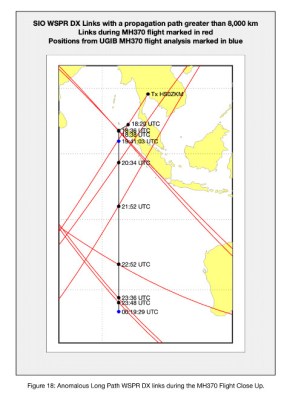
How do you explain WSPR links meeting at the crash site of MH370 at 34.40°S 93.21°E?
https://www.dropbox.com/s/a40wbgyblgrdeyu/WSPR%20Links%20MH370%200020%20UTC%20Zoom%20Plus%20View.png?dl=0
May I ask your opinion on the paper titled “Scattering Mechanism of Aircraft Wake Vortices generated in Clear Air” by Jianbing Li, Xuesong Wang and Tao Wang.
May I also ask your opinion on the paper titled “Aircraft Wake Vortex Evolution and Prediction” by Dr.-Ing. Frank Holzäpfel of the Technical University Munich.
Please see my previous comment on these two papers dated 21st April 2021 at 11:09:
https://www.mh370search.com/2021/04/03/wsprnet-and-inmarsat-satellite-data/comment-page-1/#comment-595
May I also ask your opinion on the presentation by Dr. Robert Westphal titled “Geocaching in the Ionosphere” given at the international amateur radio scientific workshop HamSCI 2021 held on 19th – 20th March 2021 and hosted by the University of Scranton, Pennsylvania, USA.
Please see the Guest Post on 22nd March 2021:
https://www.mh370search.com/2021/03/22/guest-post-by-dr-robert-westphal/
There are a number of other studies on the subject of aircraft detection, WPSR and the radio physics involved that present an alternative view to yours. Are they all wrong?
Why not just set up two GSP locked stations in similar positions to the ones used in your 2014 data study and get one to transmit at 50% frequency for a day whilst noting and recording the traces/data on the RX side when a plane is present along the path in the area of your study and when the path is free of aircraft. You could then present two data sets of with plane and without plane and see if you could detect any differences in SNR or drift. If not, then you know it’s not useful and move on. Perhaps someone might do this very soon and publish the results so we can all move on. I suspect that many experienced ‘amateurs’ posting on this site already know the answer to such a study.
Remember, all of the studies you are pointing to in your above comment are just studies of unproven theory. Before asking people to prove your theories wrong, you first need to prove they are correct and applicable to low power WSPR signals. From what I can see you have a very long way to travel with many hops to overcome in a literal and radio sense. For example, a HF military radar can accurately detect a plane over the horizon using a 500KW transmitter, but if the same radar was using only 10W could it still detect the same aircraft with any precision ? And, if we extended that 10W signal from just over the horizon to half way around the world how do you think the military would rate it’s accuracy. Well, interestingly, the 500KW radars they use today only have accuracy for a single hop. So you can see that you have a tough task ahead unless someone does that test setup study within the next few weeks and puts all of this to rest.
“How do you explain WSPR links meeting at the crash site of MH370 at 34.40°S 93.21°E?”
A crash site can only be confirmed when we find the wreckage. This type of false claim does you and your group no favours.
Yes they are all B.S. or taken out of context.
You need to give it up before you get yourself into legal trouble.
Richard, I see that you are making headlines again, raising false hopes. A reply back in April seemed pointless since you didn’t address the main issue, and after looking at your similar whaddabout responses to critiques from WSPR experts on your blog, anyone would be put off. Even your co-author Dr Westphal confessed in a long post there on May 5, “I… still have my doubts on LP in the case of MH370.” (LP meaning Long Paths)
That is the problem with your approach. All of the past research you cite, including Rob’s work, has been for relatively short distances up to a few skips. Rob says up to 7,500, km. The fundamental meter reference was once defined by 10,000 km being the distance from the equator to the pole.
I have seen good evidence of forward aircraft scatter at high HF and VHF frequencies over a skip or even two. That’s not the problem. You are looking for variations in signal strength. Your supposed wake vortex scattering would reduce the signal, so you need a recent previous “spot” contact to reference. For your method to work, you need a regular stream of signal reports. That only comes from the shortest of global paths. But at the same time, you falsely assume that each contact signal you use has taken the longest possible path around the globe, using dozens of skips, yet retaining the accuracy of a single skip or two.
Long path skip has been reported, but it is rare. I ran a histogram of a month of Mar 2014 WSPR contacts. The number of daily spots decays exponentially with distance. Beyond 19,000km, it takes 3-4 days on average between connections. You are instead taking frequent 1,500km spot paths and projecting them as 38,500km paths, and further assuming that any signal variation is due to your chosen target.
The original premise for using WSPR to find MH370 was that a forward focusing diffraction with downward reflection can boost a signal, potentially providing a link path that would otherwise be too weak. That showed some promise but needed validation. By jumping the gun and misusing the WSPR data with false assumptions, even that method has now lost all support.
Headlines claim you have “proven” that your method works by tracking planes in “blind” tests. Except that you had enough details about the two flights to guess known departure routes. In tracking the S&R flight, you had the GPS track, and merely picked from a dense network of semi-random reverse projections to repeatedly confirm your matching method. It would undoubtedly work just as well for any given flight or ship path, even if you applied it on the wrong day.
You have yet to address the fundamental flaw in your approach, which is assuming that HF signals propagate more easily yet accurately taking the longest possible path between two nearby points on the globe.
You sound honest. So you should just say the WSPR idea is balderdash.
My most optimistic calculation is this. Given a 1kw transmitter, a 1000 sqm aircraft radar cross section at 1000km will intercept and reflect -41dBm. Another 1000km away that will be received 132dB lower (1/(4PiE12) per sqm that is -173dBm/sqm. At 14MHz (20m band) the receiving antenna capture area might be 400sqm giving received power of -147dBm.
That would be 0dB SNR in a 400 Hz BW if there was no receiver or atmospheric noise. But realistically receiver plus atmospheric noise is at least 20dB over KT at 14MHz and you need at least a 10dB SNR to be detectable. And the above is assuming zero loss on two ionospheric reflections.
Then from what direction is this signal hitting the aircraft? If it’s coming down from the Ionosphere, the vast majority of the power misses the aircraft and hits the ocean, which is a much better reflector and reflections from the vast ocean would drown out the tiny amount reflected from the aircraft. Basically it’s a 2 hop path with the ocean joining the two hops and the aircraft if going to contribute nothing to that.
The meeting of the great circles at (-34.40,93.21) is explained by first recognizing that all great circles crossing a point on the globe will also cross the antipode of that point. It turns out that (-34.40,93.21) is the antipode of WSPR station WB8ELK at (34.40,-86.79). WB8ELK is in Alabama, US. At 00:20 UTC, 10 stations reported receiving a signal from WB8ELK. Those receivers are located in the US, Canada, and Western Europe. The proposed figure showing the hypothetical crash site of MH370 in the SIO shows 7 of those great circles intersecting at the antipode of WB8ELK. This was explained in comments on my blog:
https://mh370.radiantphysics.com/2021/03/07/two-new-reports-on-mh370-debris-suggest-a-high-speed-final-descent/#comment-31339
In short, the intersection of WSPR paths at (-34.40,93.21) has nothing to do with MH370.
For the last 15 years or so, law enforcement agencies (and others) have been putting GPS trackers on vehicles and boats for the specific purpose of transmitting their position back to a central point. This device is the size and shape of a pack of cigarettes, is entirely self-contained including GPS receiver, Iridium transmitter, battery and antennas. I realize there are aircraft certification requirements but the technology to keep track of airplanes would seem to be in hand, if anyone wishes to use it.
Those require a local mobile phone network. Those are inconveniently absent in the places where most planes tend to crash, thus this would be a pretty useless thing to add to a plane.
The original trackers did in fact use a cell phone module. The units began to be deployed in areas where there was poor cell coverage – Afghanistan, eg – which is why we started putting in Iridium modules which provide world-wide coverage. A lot of trackers still use cell phone modules where appropriate.
I can see your point about Iridium tracking not being more commonly used for planes.
I *guess* the main reason would be because it’s so incredibly rare for planes to disappear in ways these sorts of trackers would be helpful for, nobody goes through with the effort/expense.
I mean, how often does this happen. Situations like MH370, where an “Iridium tracker calls home anytime something seems out of the ordinary” setup would have been helpful ? In the case of MH370, it would have helped, the expense would have made sense. But for *every other plane ever* it seems, it would just have been money wasted … right?
And it’s not like having the tracker there is going to bring the passengers back to life… all the tracker is going to do is *maybe* give us some insight on whether this was an accident or a suicide-by-plane. Or answer other similar questions, that don’t really benefit the plane company, or society in general, right? All in all, the tracker would be an expense on all planes, for *extremely* tenuous benefits …
Unless I’m missing something, I would think this explains why we don’t see these trackers used.
Transmit continuous GPS position at 59 bauds around 5MHz HF. All equipement is aleady on board. Plenty of stations would pick that up.
The answer lies in the AWACS log book. US is hiding the answer for some reason; pretty easy to figure out why