
Since October 1978, the National Oceanic and Atmospheric Administration (NOAA) has operated its fleet of Polar-orbiting Operational Environmental Satellites (POES) — the data from which has been used for a wide array of environmental monitoring applications, from weather forecasting to the detection of forest fires and volcanic eruptions. But technology marches on, and considering that even the youngest member of the fleet has been in orbit for 16 years, NOAA has decided to retire the remaining operational POES satellites on June 16th.

Under normal circumstances, the retirement of weather satellites wouldn’t have a great impact on our community. But in this case, the satellites in question utilize the Automatic Picture Transmission (APT), Low-Rate Picture Transmission (LRPT), and High Resolution Picture Transmission (HRPT) protocols, all of which can be received by affordable software defined radios (SDRs) such as the RTL-SDR and easily decoded using free and open source software.
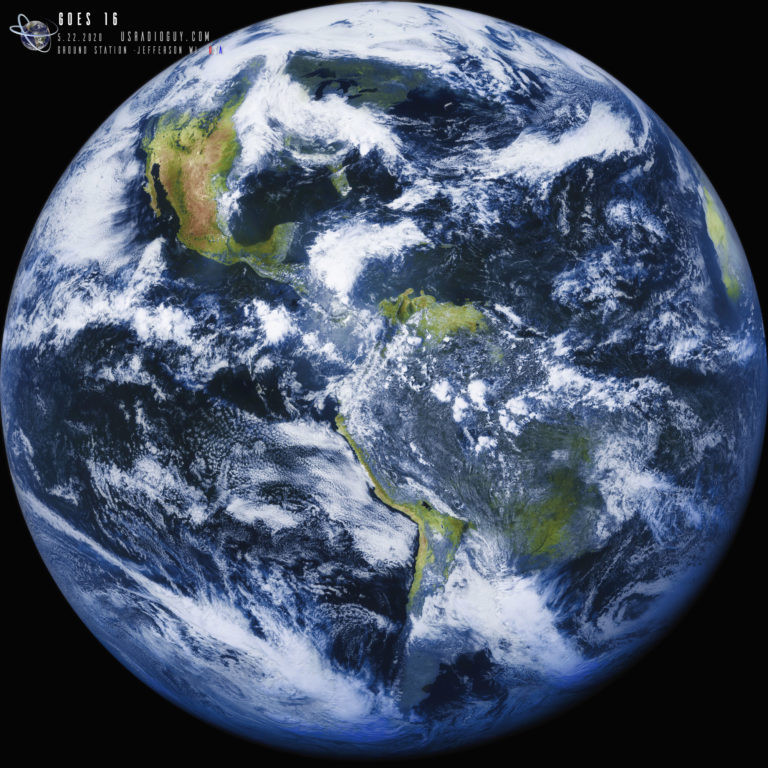
As such, many a radio hobbyist has pointed their DIY antennas at these particular satellites and pulled down stunning pictures of the Earth. It’s the kind of thing that’s impressive enough to get new folks interested in experimenting with radio, and losing it would be a big blow to the hobby.
Luckily, it’s not all bad news. While one of the NOAA satellites slated for retirement is already down for good, at least two remaining birds should be broadcasting publicly accessible imagery for the foreseeable future.
Not For Operational Use
The story starts in January, when NOAA announced that it would soon stop actively maintaining the three remaining operational POES satellites: NOAA-15, NOAA-18, and NOAA-19. At the time, the agency said there were currently no plans to decommission the spacecraft, and that anything they transmitted back down to Earth should be considered “data of opportunity” rather than a reliable source of information.
However, things appeared to have changed by April when NOAA sent out an update with what seemed like conflicting information. The update said that delivery of all data from the satellites would be terminated on June 16th, and that any users should switch over to other sources. Taken at face value, this certainly sounded like the end of amateurs being able to receive images from these particular satellites.
This was enough of a concern for radio hobbyists that Carl Reinemann, who operates the SDR-focused website USRadioguy.com, reached out to NOAA’s Office of Satellite and Product Operations for clarification. It was explained that the intent of the notice was to inform the public that NOAA would no longer be using or disseminating any of the data collected by the POES satellites, not that they would stop transmitting data entirely.
Further, the APT, LRPT, and HRPT services were to remain active and operate as before. The only difference now would be that the agency couldn’t guarantee how long the data would be available. Should there be any errors or failures on the spacecraft, NOAA won’t address them. In official government parlance, from June 16th, the feeds from the satellites would be considered unsuitable for “operational use.”

In other words, NOAA-15, NOAA-18, and NOAA-19 are free to beam Earth images down to anyone who cares to listen, but when they stop working, they will very likely stop working for good.
NOAA-18’s Early Retirement
As it turns out, it wouldn’t take long before this new arrangement was put to the test. At the end of May, NOAA-15’s S-band radio suffered some sort of failure, causing its output power to drop from its normal 7 watts down to approximately 0.8 watts. This significantly degraded both the downlinked images and the telemetry coming from the spacecraft. This didn’t just make reception by hobbyists more difficult. Even NOAA’s ground stations were having trouble sifting through the noise to get any useful data. To make matters even worse, the failing radio was also the only one left onboard the spacecraft that could actually receive commands from the ground.
While the transmission power issue seemed intermittent, there was clearly something very wrong with the radio, and there was no backup unit to switch over to. Concerned that they might lose control of the satellite entirely, ground controllers quickly made the decision to decommission NOAA-18 on June 6th.
Due to their limited propulsion systems, the POES satellites are unable to de-orbit themselves. So the decommissioning process instead tries to render the spacecraft as inert as possible. This includes turning off all transmitters, venting any remaining propellant into space, and finally, disconnecting all of the batteries from their chargers so they will eventually go flat.
At first glance, this might seem like a rash decision. After all, it was just a glitchy transmitter. What does it matter if NOAA wasn’t planning on using any more data from the satellite in a week or two anyway? But the decision makes more sense when you consider the fate of earlier NOAA POES satellites.
Curse of the Big Four
When one satellite breaks up in orbit, it’s an anomaly. When a second one goes to pieces, it’s time to start looking for commonality between the events. But when four similar spacecraft all explode in the same way…it’s clear you’ve got a serious problem.
That’s precisely what happened with NOAA-16, NOAA-17, and two of their counterparts from the Defense Meteorological Satellite Program (DMSP), DMSP F11, and DMSP F13, between 2015 and 2021. While it’s nearly impossible to come to a definitive conclusion about what happened to the vehicles, collectively referred to as the “Big Four” in the NOAA-17 Break-up Engineering Investigation’s 2023 report, the most likely cause is a violent rupture of the craft’s Ni-Cd battery pack due to extreme overcharging.
What’s interesting is that NOAA-16 and 17, as well as DMSP F11, had gone through the decommissioning process before their respective breakups. As mentioned earlier, the final phase of the deactivation process is the disconnection of all batteries from the charging system. The NOAA-17 investigation was unable to fully explain how the batteries on these spacecraft could have become overcharged in this state, but speculated it may be possible that some fault in the electrical system inadvertently allowed the batteries to be charged through what normally would have been a discharge path.
As such, there’s no guarantee that the now decommissioned NOAA-18 is actually safe from a design flaw that destroyed its two immediate predecessors. But considering the risk of not disconnecting the charge circuits on a spacecraft design that’s known to be prone to overcharging its batteries, it’s not hard to see why NOAA went ahead with the shutdown process while they still had the chance.
The Future of Satellite Sniffing
While there are no immediate plans to decommission NOAA-15 and 19, it’s clear that the writing is on the wall. Especially considering the issues NOAA-15 has had in the past. These birds aren’t getting any younger, and eventually they’ll go dark, especially now that they’re no longer being actively managed.
So does that mean the end of DIY satellite imagery? Thankfully, no. While it’s true that NOAA-15 and 19 are the only two satellites still transmitting the analog APT protocol, the digital LRPT and HRPT protocols are currently in use by the latest Russian weather satellites. Meteor-M 2-3 was launched in June 2023, and Meteor-M 2-4 went up in February 2024, so both should be around for quite some time. In addition, at least four more satellites in the Meteor-M family are slated for launch by 2042.
So, between Russia’s Meteor fleet and the NOAA GOES satellites in geosynchronous orbit, hobbyists should still have plenty to point their antennas at in the coming years.


That’s kinda a shame. What “other sources” should we be considering other than Meteor and GOES?
JPSS series, MetOp series, FY-3 series, Suomi NPP.
There used to be Meteosats, but I don’t know if they still operate.
https://www.sigidwiki.com/wiki/Meteosat_WEFAX
Metoesats are under the horizon for CONUS operations, so those of us in the western hemisphere would have to use Internet feeds to work with that imagery.
Well, I take that back a bit… maybe not such a loss. POES has 1.1km resolution, and GOES has improved since my operational weather days to be roughly equivalent.
Did they “decide to” or were they forced to by the DOGE idiots or the idiots in the White House?
Yeah, a DOGE rep climbed up there and broke the radio on Donald Trump’s orders. You cracked the case, gumshoe.
NOAA has already had to cut many other programs due to DODGE cuts that likely cost considerably more than maintaining the operations of POES. So it is likely that there was a budget consideration during the meetings concerning canceling POES operations (or was even the prompt that started the discussion). There is no doubt that if they had an abundance of funding, the talk wouldn’t even be happening, other than on a case by case, true hardware retirement concern basis. Unfortunately for us, POES is the lowest of the low hanging fruit at NOAA, and It’s data hasn’t been of significant scientific / weather forecasting value for a long time (at least compared to every other project at NOAA).
Much more concerning is the cancelation of a lot of programs related to hurricane and tornado research, leaving it up to “only” GEOS data. This work literally saves lives and millions/billions of dollars due to destruction every year. Its “boots on the ground” and planes in the air. Expensive but vital work.
I stopped capturing images for NOAA-15/18/19 some time ago anyway. The Meteor satellites give better pictures.
True enough… but I have never really mastered LRPT captures. APT was so forgiving.
I never understood the logic of shutting down a satellite that’s still perfectly functional. Why not simply leave it alone and let people enjoy it? (yes, I know this isn’t always possible)
yeah same until I read the article. When the alternative is to let people enjoy playing with the unmanaged sat UNTIL it one day kersplodes, this sadly is just not an option.
The problem is if it fails screaming, then that band of the RF spectrum can not be used until it is finally dead dead. Where as telling it to kill itself just before that is no longer possible, means that that band of the RF spectrum can be allocated to other satellite(s) without having to wait for a useless satellite to slowly fall back to earth and eventually burn up.
NOAA-18 is at an altitude of 854 km and a mass of between 2232 kg (full fuel tanks) and 1479 kg (empty fuel tanks) with an area of approximately 16.76 m² (solar array), so if waiting on an object with area to mass at that altitude to naturally de-orbit you could be talking 50 to 75 years. That is a lot of time to potentially not be able to use a block of RF spectrum.
Thanks for the shout out to my site, useadioguy.com. Hope the information helps folks out,
Carl
This article is very misleading. The POES satellites are old as hell and most are no longer operational. The last remaining ones are being decommissioned this year. The Joint Polar Satellite System (JPSS) is NOAA’s more advanced next-generation constellation of polar orbiting satellites which are working fine. There was talk that NOAA-18 was also affected by a geomagnetic storm caused by solar activity, which contributed to its partial radio transmitter failure and thus, early shut down. I also doubt that USRadioGuy produced that GOES-16 image.
An alternative would be the MetOp data from EUMETSAT.
Without Internet you can have imagery via EUMETCAST which is transmitted via satellite directly (you need to be somewhat lucky to be in coverage when located in America).
Otherwise the data is offered via DataStore which has an online API and a python client called eumdac which is available in PyPi.
And then there is also EUMETView which visualizes the data in your browser (also has an API)
Some links:
– https://view.eumetsat.int
– https://user.eumetsat.int/data-access/eumetcast-europe
– https://data.eumetsat.int
– https://pypi.org/project/eumdac/