One of the simple pleasures of life is enjoying a drive to work… only to get stuck in traffic that you could’ve known about if you just checked before your daily commute. Who are we kidding? There’s almost nothing worse. [Michael Rechtin] saw this as a great opportunity to spruce up his living room with something practical, a coffee table that serves as a traffic map of Cincinnati.
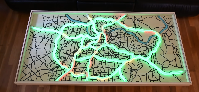
The table itself is fairly standard with mitered joints at the corners and coated in polyurethane. Bolt on a few legs, and you’ve got a coffee table. But the fun comes with the fancy design on top. A CNC-cut map of Cincinnati is laid out under a sheet of glass. Roads and rivers are painted for a nice touch.
Of course, none of the woodcraft is what gets the attention. This is where the LED light show comes in. On top of the map resides an animated display of either road conditions or the other five pre-programmed animations. The animations include color-coded highways or the good ole’ gamer RGB. To control all of the topographic goodness, a Raspberry Pi is included with some power regulation underneath the table. Every minute, the Pi is able to grab live traffic data from the cloud to display on top.
A looker, this project shows how our hacking fun can be integrated directly into our everyday life in more subtle ways. When we want to decorate ourselves, however, we might want to turn to more personal fare. Check out this miniature liquid simulation pendant for some more everyday design.


Super idea. What I miss/wonder though is the current situation can be augmented with the predicted upcomming situation. On longer commutes, everything is fine now, but in 30 minutes from now, things may be quite different, as they always are on tuesdays for example …
In Europe (or at least The Netherlands), TomTom has all the source data you need for that. But I think you will need a subscription for it.
Here we have had gratis https://en.wikipedia.org/wiki/Traffic_message_channel for ages, and it works with just a car radio alone or a satnav.
I forget how well with a radio, but fex Garmins will adjust route, if there are long delays.
Of course my most used, a Zumo, does not support RDS-TMC, but wants to use an application + subscription on a cell phone.
Nice table. Given the CNC mill though, I’d have been tempted to drill holes in the roads for discrete LEDs. That’d have given the xy coords (and easily derivable GPS) for each one. Then a slop of resin over the top.
Again, I don’t know about the US, but in Europe, TomTom has the current traffic speed per 100m piece of road, and up to date for the minute. Same for weekly trends of traffic speed per 100m piece of road, but per 5 minute interval.
You can combine both to make predictions. Although I think you can also retrieve predictions from TomTom themselves as well. But I’m less sure of that.
I’m not sure about the resolution of Google’s traffic information. And I also know that TomTom has actively been frustrated in the US. So your mileage may very well be different. But maybe worth investigating.
When I saw the first picture, I immediately thought “that almost looks like Cincinnati but the river is to the north. I wonder what city it is.” lol. I lived and worked there for years so I know the map but I still recognized it as familiar even upside down before my intellect made a bad assumption that N was up, overriding my intuition.
Brilliant!
I could see this in a pimped out rv
“Hey Martha, hold the steering wheel while I check the coffee table”