Quadcopters show a world of promise, and not just in the mediums of advertising and flying Phantoms over very large crowds. They can also be used for useful things, and [Sagar]’s entry for The Hackaday Prize does just that. He’s developing a 3D mapping drone for farmers, miners, students, and anyone else who would like high-resolution 3D maps of their local terrain.
Most high-end mapping and photography work done with quadcopters these days uses heavy DSLRs to record the images that are brought back to the base station to be stitched into a 3D image. While this works, those GoPros are getting really, really good these days, and with 4k resolution, too. [Sagar] is mounting one of these to a custom quad and flying around an area to get images of an area from every angle.
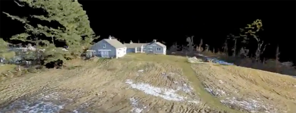
To stitch the images together [Sagar] will be using the Pix4D mapping software, an impressive bit of software that will convert a multitude of still images to a 3D scene. It’s an expensive piece of software – $8500 for a perpetual license, but the software can be rented for $350/month until a FOSS alternative can be developed.