
What is this world coming to when a weather satellite that was designed for a two-year mission starts to fail 21 years after launch? I mean, really — where’s the pride these days?
All kidding aside, it seems like NOAA-15, a satellite launched in 1998 to monitor surface temperatures and other meteorologic and climatologic parameters, has recently started showing its age. This is the way of things, and generally the decommissioning of a satellite is of little note to the general public, except possibly when it deorbits in a spectacular but brief display across the sky.
But NOAA-15 and her sister satellites have a keen following among a community of enthusiasts who spend their time teasing signals from them as they whiz overhead, using homemade antennas and cheap SDR receivers. It was these hobbyists who were among the first to notice NOAA-15’s woes, and over the past weeks they’ve been busy alternately lamenting and celebrating as the satellite’s signals come and go. Their on-again, off-again romance with the satellite is worth a look, as is the what exactly is going wrong with this bird in the first place.
Eye in the Sky

NOAA-15’s heritage stretches back to the early 1960s, when meteorologists realized that satellites with infrared imagers would be a dandy way to gather data on surface temperatures, water vapor distribution, and other parameters that go into a decent weather forecast. The first of the Television Infrared Observation Satellites, or TIROS, were extremely simple satellites, carrying little more than a TV camera and a transmitter. But these satellites returned the first pictures of Earth from space, and provided the first glimpse of what the future of remote sensing held.
Forty-odd years later, weather satellites had more than proven their worth, and under the auspices of the National Oceanic and Atmospheric Administration, the US government body responsible for gathering weather and climate data and turning it into useful products, an impressive constellation of weather satellites was in service. NOAA-15 was added to this constellation, along with identical sisters NOAA-16 and NOAA-17.
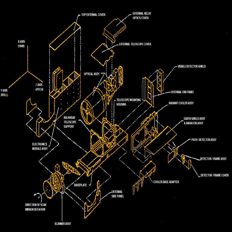
Known collectively as NOAA KLM, each satellite had a slightly different sun-synchronous orbit, and each was equipped with the latest in remote sensing technology. In addition to microwave sounding units of the type that are potentially at risk by the 5G cell phone rollout, the NOAA KLM satellites were equipped with an instrument known as the AVHRR, or Advanced Very-High Resolution Radiometer. This instrument was to be the workhorse of the satellites, producing images of the Earth below in six different wavelengths in the visible and infrared.
To produce images, a scanning motor rotates a flat beryllium mirror mounted at an angle in front of an 8″ (20 cm) reflecting telescope. The motor rotates the mirror at 360 RPM, which scans the surface below in 1.09-km wide strips. The data from each strip is digitized and transmitted over a VHF radio link, specifically designed so that low-cost ground stations would be able to receive and decode the transmissions directly.
Easy Listening
NOAA KLM’s designers likely never envisioned that their satellite would last more than ten times longer than its design life, let alone that it would still be in service when the age of cheap software-defined radios would come along. But their decision to make the downlink open and accessible is the key to how radio enthusiasts have been listening in on the birds, in good times at first, and now in bad.
Listening to NOAA satellites is actually quite easy; we’ve covered how to do it since at least this 2012 article. The basic setup for a minimal ground station is an SDR dongle, easily had from the usual suspects for a couple of bucks; an antenna that can be as simple as a 2-meter long piece of wire jammed into the SDR’s antenna jack; and a simple toolchain of software on the host PC, which ends with WxToIMG, and app that not only decodes the data coming back from the downlink and reassembles an image, but also tells you when the satellite is over your location. Setups can grow from there, with better antennas, sensitive amps, and better quality SDRs, but the basics remain very affordable.
Up until this year, the images received from NOAA-15 were pretty much normal. Results vary based on the setup used, and there’s always some noise in the signal, but in general the images were more than usable. But images sent back to the ground in mid-April started showing artifacts — wide bands of colors that were clearly not simple RF noise or some other previously seen interference. The RTL-SDR subreddit went abuzz with threads speculating on the cause, which was eventually confirmed by NASA to be some sort of failure in the scan motor for the AVHRR.
On-Again, Off-Again
NOAA-15’s troubles were only temporary, though, and the scanner motor seemed to unstick itself. But the problem came back in late July, with even more artifacts in the images. NASA released its analysis of the telemetry data, which indicated both a sudden spike in the current drawn by the scan motor to 302 mA, as well as an increase in the temperature of the scanning assembly. This pointed to a stalled motor, likely due to worn-out bearings in the scanner head. The AVHRR was no longer producing data, and it looked like the end had finally come for NOAA-15.

The AVHRR came back to life on July 25, producing data again for several days. On July 30, the motor stalled again, and this time it seemed like the AVHRR wouldn’t recover to a reliable state. Yet there were more reports on August 7th that reliable images were once more streaming down.
NOAA-15 has been a backup satellite since the launch of NOAA-18 in 2005 and NOAA-19 in 2009, so weather data will still flow in its absence. It’s likely that the doomed satellite will soon be decommissioned, and when it is, enthusiasts will no doubt be tuning their SDRs to listen in once it’s boosted to a graveyard orbit.


Too bad for NOAA-15.
Are NOAA-16 and NOAA-17, mentioned in the article, alive? Is any other, similar, accessible for easy receive of data? :)
I believe NOAA-16 was decommissioned in 2014. It broke up in orbit in 2015 – I think it had been moved to a graveyard orbit.
NOAA-17 was decommissioned in 2013.
NOAA-18 and 19 are up, and use the same frequencies. There’s also Meteor and GOES satellites you can download data from, but the process is a little different.
So yes, definitely weather birds out there that you can listen in on with a cheap SDR.
18 and 19 are still alive. I got an APT pass on 137.100 yesterday.
So they are still at relatively low frequencies. So much for needing an SDR.
People were receiving satellite photos almost as soon as satellites started sending them. One ham magazine in the later sixties had a story about someone in the UK doing this, when it was a big thing, and it even got the satellite owner interested.
But people have done it for decades, the real problem was display rather than receiving hardware. I think some used fax machines (there were surplus fax machines, different from the later consumer machines) or buikt CRT displays. I think there was some overlap with SSTV, so so some used their SSTV equipment.
At 137MHz, it didn’t take much of antenna, and one coukd either buikd a converter to use with an existing receiver, buikd a complete receiver, or modify something. A radio scanner tgat covered tge frequency but with FM detector was used sometimes, I remember one article modifying obe for wider bandwidth, since the deviatiin was a bit wider, but also to allow for doppler shift.
There were lots offer articles, and one may as ne even collected some into a book, which maybe is online by now.
Michael
“which ends with WxToIMG, and app ”
s/and/an
expression #1, ch ar 8: unterminated `s’ command
WxToIMG seems to be offline, but I did find wxtoimgrestored.xyz, which is a mirror.
It’s online, but only displaying:
Index of /
Name Last modified Size Description
So, are the microwave sensors working?
Too many moving parts. Spin the whole satellite and use a tiny galvanic mirror to step a scan each revolution and redirect the sunlight on the backside of the revolution. Positional awareness easily detected by the sunlight striking the solar cells encircling the chassis. Cubesat anyone?
It would need to spin quite fast. At least a few times per second to get the NOAA-15 scan performance. Seems non trivial to me to prevent the sat from breaking apart, it is a large thing.
In space, that would be moot rather moot. It just needs to be slowly sped up. There is no air friction to contend with and it is of such small mass that there would be little or no deflection anywhere. Should be doable.
Very difficult to keep fine orbital control on a fast spinning satellite. That’s just swapping one problem for another. Plus you lose the stable platform for all the OTHER measurement equipment on the same satellite. The spinning mirror solution seems to have worked more than satisfactorily far past it’s expected lifetime.
Another reason you don’t see big spin-stabilized satellites anymore is power. You can only stick so many solar cells on to the body. The arrays on three-axis stabilized satellites get you a lot more juice for the payload.
I recall the Japan Meteorological Agency GMS Satellite falling out of orbit in 2008:
https://web.archive.org/web/20080720170959/http://www.eng.jcu.edu.au/JCUMetSat/ausmovie.gif and https://web.archive.org/web/20080722055951/http://eng.jcu.edu.au/JCUMetSat/globemovie.gif
i bet if someone made a cheap collapsible helical antenna and bundled it with a sdr stick as a kit for doing exactly this, it would sell like hotcakes …
Yeah, we can only hope…
Actually though, the RTL-SDR.Com people sell a kit on amazon that includes a dipole, which can be configured into a V-Dipole. This is very effective for weather satellites.
I made a collapsible quadrifiliar helix for APT/SDR while camping. It worked great right up until it got knocked onto the ground and subsequently run over by a Jeep. I used RG-59 as antenna elements and RG-6 for feedline, and PVC pipes that were concentrically-mated to telescope with locking pins for structure, and (some kind of plastic) driveway edge marker rods for lateral supports. It all broke down into something that would fit into a modestly-sized backpack.
This useful website keeps list of currently working weather satellites : http://phqfh.co.uk/status.htm
I figure since it’s in a relatively low 807km orbit they’d deorbit it vs boost it into a graveyard orbit.
Congratulations NOAA-15 ´s designers for surpassing 19 years from early life expectancy! Great design! Please keep up the good work !!!
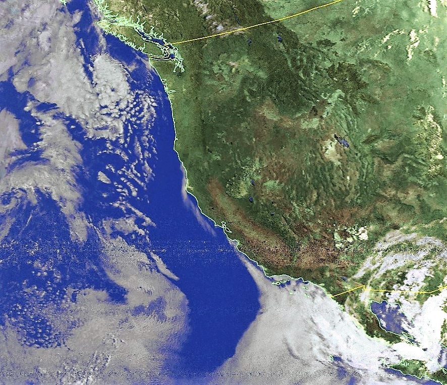
On the 24th & 25th of July I downloaded images from NOAA-15 as shown below:
1. http://nortical.net/images/NOAA-15/24thjuly2019.jpg
2. http://nortical.net/images/NOAA-15/25thjuly2019.jpg
I immediately knew that it was a repeat of the April 2018 incident, whereby the scan motor current draw had became erratic due to loss of lubricant and a few partially corrupt images were beamed, but from which it subsequently recovered. However, this time round the corruption was a lot more and the message put out by NOAA was really saddening ‘Options for recovery are limited.’
Let us all rejoice that NOAA-15 outlived its mission duration by a whooping 19 years and that we still have NOAA-18 & 19 working beautifully, beaming quality images day and night.
It’s 2022 and Noaa15 is still operational and transmitting good images.
NOAA 15 is still operational as of 2022. I receive the HRPT downlink (1.7GHz) with a 1m dish and it seems to be quite stable, however the signal is quite weak due to a broken antenna. The images are alright. Either way – it’s running :)
Also, if I am understanding it correctly, it should be “scanning it in 2800 km strips” since it scans with a width of about 2800km (I can’t remember the exact number off the top of my head). 1.09 is the resolution per pixel. Also, the resolution decreases from the nadir so go figure :)
Sorry, the swath width is 2160 km