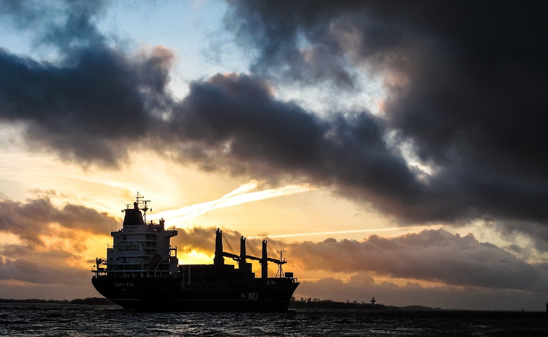
It would seem that for as long as there have been ships on the ocean, there’s been smuggling. The International Maritime Organisation requires ships to have AIS, the automatic identification system which is akin to a transponder on an airplane. However, if you don’t want to be found, you often turn off your AIS. So how do governments and insurance companies track so-called dark ships? Using satellite technology. A recent post in Global Investigative Journal tells the story of how lower-cost satellites are helping track these dark ships.
Optical tracking is the obvious method, but satellites that can image ships can be expensive and have problems with things like clouds. Radar is another option, but — again — an expensive option if you aren’t a big military agency with money to spend. A company called HawkEye 360 uses smallsats to monitor ship’s RF emissions, which is much less expensive and resource-intensive than traditional methods. Although the data may still require correlation with other methods like optical sensing, it is still cost-effective compared to simply scanning the ocean for ships.
The post tells the tale of an Iranian crude oil tanker. Noting a long gap in the AIS signal from the ship, HawkEye 360 attempted to locate the ship the next time it went dark. Of course, AIS can be off for other reasons, such as equipment failure or fear of piracy. Simply not squawking AIS isn’t a definite sign of malfeasance.
Using the satellite, radio transmissions on VHF channel 16 (156.8 MHz) — the standard calling frequency — were found from the ship and it appeared they were offloading crude oil to a refinery in Syria. With a specific target in mind, commercial satellite imaging picked up 3-meter resolution images of the ships and — apparently there is a database of ships at that resolution — identified four Iranian flag tankers at the site, three of which had arrived in stealth mode.
The HawkEye 360 satellites can pick up radar, emergency beacons, satellite phones, and VHF radio signals. A map shows the difference between the number of AIS signals in the South China Sea and the number of X-band radar signals. The AIS map looks sparse, whereas the radar map shows 3-4 times the number of vessels.
In another example, uses ESA’s Sentinel 1 satellite and synthetic aperture radar to locate ships going from China to North Korea. ICEYE, another smallsat company, is tracing illegal fishing activity around Argentina and smuggling near the UAE.
It is amazing to see how much satellite tech that would have been deep secret a few years ago is now commercially available. It isn’t just useful for law enforcement, either. The resolution is a far cry from the old weather satellites people tend to eavesdrop on.


Enemy of the state, may soon be possible.
Only if you are the size of a ship.
It already is. Just not from orbit.
RF is cheaper than optical? Huh. Thanks for turning me on to something I didn’t even know existed.
With optical, you have to scan every single piece of the entire huge ocean with a resolution of 100m or better. RF can be picked up with a wide-angle antenna and then narrowed down or triangulated. Correlate that with the known position of AIS enabled ships and you can easily get an approximate position of dark ships. I guess that is whats happening here. An RF sat can scan a much bigger field then an optical camera can.
That and you can easily blind an optical sensor on the ocean by just putting a bunch of mirrors on the top of your ship so that the sun is reflected at any satellites, hell something like a nightclub Disco-ball would be pretty effective. And the ocean isn’t exactly lacking in objects that will glint and ruin your images. Combine that with the fact that the satellite is going to be in motion (And only has a tiny window in which to see the ship) and it becomes really easy to hide your ship from cameras.
RF isn’t all that great either, you could easily just bribe a ship with a legitimate reason to be in the area to follow you, so that any RF signals would be assumed to be coming from them.
I’m gonna slap a big ol’ “citation needed” on that “you can blind cameras with disco balls” assertion.
I think it demands an experiment. Who’s up for building the worlds largest array of disco balls?
Shout out to Toronto’s UTIAS/Space Flight Labs, who built those Hawkeyes.
If you read about the Suez canal incident you will discover that a strong wind caused the ship to move out of position.
“gusting winds of 30 knots caused the container ship to deviate from its course, suspectedly leading to the grounding.”
Simple sure solution: Don’t use any radios etc. Pretty sure solution: Turn AIS etc. off, and if you must use a radio coordinate in advance what channel/frequency to use as long as it is NOT the channel these spy satellites listen on (VHF ch. 16 it seems).
OK, we’ll have to talk about easy: You sail a ocean-worthy ship without radar… not in a port environment. You’ll have to know when to turn that off; too late, and someone will already know you’re on your way and wonder where you’ve gone, too early, and you’ll run over some returning fishermen, and that just delays everything.
Even if turning off ship radar is feasible: “Easy” depends on what you’re smuggling; if it’s containerized cargo, don’t underestimate the amount of electronics running in these. Cooling containers might not only contain a diesel generator, but also local networking / GSM equipment for telemetry / mesh purposes.
If you’re smuggling cars (which first sounds strange, why smuggle a legal good available for export anywhere, but then remember that trade embargoes often try to target a wealthy upper class), you *really* need to make sure to disconnect the battery and quite possibly leave it that way for a couple of days before disbarking with modern cars. I don’t know how you’d even disable wireless tire pressure sensors, but you’ll have to do that. 433 MHz TPMS will give away your location as well as being unique identifiers…
If you’re trafficking humans, no matter whether you’re doing it for humanitarian reasons, profit or indirect profit through forced labor/prostitution, you’ll need to make darn sure nobody turns on their phone.
I’ve not done any research into modern oil / chem tankers, but it does seem likely you’d want to be triple sure the replacement valve for that leaky thing at the bow of the ship doesn’t have the ability to report operational state using any of the low power wide area networking standards that emerged in the last decade.
Now, ore, grain, coal would seem to be easy, especially because as insensitive bulk goods they are, even legally, often transported in the least-well-connected, single hull, run down freight ships.
Then you only need a trustworthy crew that knows how to operate the aircraft mode on their phones, doesn’t bring any gaming consoles or modern TVs on board, and trustworthy suppliers that don’t put product flow tracking devices into the bulk goods (e.g. tennis-ball sized IoT devices that log and broadcast environmental factors like humidity and temperature, which make a difference for grain, or when you need to prove the quality of your coal).
I guess I’d better get back to work on that cargo submarine concept…
A clandestine way for a nation-state to smuggle things…nuclear. ;-)
It was used to be pretty big business importing illegal Skyline GT’s (since they never passed DOT in the US) at 30k-40k profit for the cars
“If you’re smuggling cars (which first sounds strange, why smuggle a legal good available for export anywhere, but then remember that trade embargoes often try to target a wealthy upper class), ”
IIRC, Jordan had a 200% tariff on incoming luxury cars in the 1980s.
So, the story goes; a wealthy man wanted a top of the line Mercedes, and thought how he might avoid the tariff.
He ended up buy 2 of the cars (each loaded with accessories). When the cars arrived, the Port of Entry (or whatever) called him and told him the cars were available and to bring enough money to cover the tariff on both of them. He arrived and said, “Oh! But one of these cars is a gift to King Hussein!”
King Hussein heard about it, and was so delighted that one of his subjects would do such a thing, that he wrote off the tariff for both vehicles. On top of that, he allowed the other car to acquire Palace license plates. So, the clever subject paid the equivalent of only 100% tariff, and his car would never receive a parking ticket.
@NotASmugglerButILikeYour Thinking said:
“Even if turning off ship radar is feasible: “Easy” depends on what you’re smuggling; if it’s containerized cargo, don’t underestimate the amount of electronics running in these.”
Good point. I know shipping containers can have asset tracking beacons attached to the surface, Some sort of Inmarsat BGAN device comes to mind. RF emitters inside a shipping container or a ship’s hold wouldn’t matter because they are effectively inside a Faraday cage.
A combination of things put Evergiven on the bank. The wind means they need additional speed to maintain rudder, but they still have to crab bit to produce the needed side-load which, on a long ship, puts the ends near the sloped banks of the canal. Once near the shallow water Bernoulli kicks in and, as the water is squeezed into a narrower gap, it speeds up, reducing the pressure and effectively drawing the ship to the bank in a self-amplification. They swerved away from the bank on one side, over-corrected and nailed the other side instead. Which might have been OK but for the hydrodynamic protrusion at the bow that carved through the soft material of the bank and hit rock, lifting the bow. Momentum did the rest and it pivoted by the bow to jam the stern up on the other bank.
A lot of other captains and owners looked at the wind conditions and decided to wait. The Evergiven gamble went bad.
Thats probably right. I can imagine that there will be volumes written on the reasons it allided with the bank.
Big brother on sea?
Expect terror from Anonymous.
All this effort is so a country can dictate another country what to do.
As usual: only lots of useless facts from me.
SOLAS says that ships with 300/500 BRZ (gross tonnage) on international/national voyage have to have AIS. 300/500 BRZ is also a limit for all the other requirements like licenses, cargo, security, navigation aids etc etc. So below 300/500 BRZ it is up to the local government rules only, no international treaties are broken.
Fishing vessels with 500 BRZ are quite huge. Really. Your idyllic local shrimpcutter is just 80 BRZ (eighty). J. Von Colln NC308/IMO 8705450 has about 460 BRZ.
H360s image of the South China Sea is roughly a circular area of 1000 km diameter. 370 km is the 200 NM EEZ limit, The South China Sea has lots of disputes about who owns what and not… (Would never happen here in Europe, Never. Civilized world, you know. Like Jersey. The British send HMS Severn & HMS Tamar while the French threaten to cut the submarine power cable. But I disgress.)
So I assume most of what we see are “private family owned” (inter-)national fishing vessels breaking all the international codes because, well, they all disagree about what is allowed and what not.
And, of course military boats that have AIS turned off most/all the time. To protect their coast.
So: misleading content.
The moment a ship hits international waters, the treaties are only binding if the flag nation is a signatory. And even then many don’t care to police their commercial fleet. Or get paid not to care.
“And even then many don’t care to police their commercial fleet.”
*cough* Panama *cough cough*
Cool stuff.
Scatter a bunch of floating solar powered baofengs set on 156.8 and there goes that …
Or just pay off someone with a legitimate reason to be there to follow you around so everyone observing you dismisses any of your signals as belonging to that legitimate vessel.
At $20 a pop a significant enough illegal operation could probably afford a few tens of thousands. Attach some to weather balloons and have them turn on and off intermittently for increased effect.
I was thinking about the GPS squirters on individual shipping containers, but onboard GPS spoofers may negate those. Although some (higher end?) GPS chips include spoofing detection on them.
The Evergiven incident may be more easily explained by a number of accounts of a number of ships over a number years. That of mandatory-pilots’ questionable skills, dedication, diligence or attention.
“Radar is another option, but — again — an expensive option if you aren’t a big military agency with money to spend.”… nope… https://www.iceye.com/use-cases/financial/logistics-site-shipping-activity-monitoring
I was buying Radarsat 1 data 20 years ago… wasn’t that expensive.
Company I work at are using SAR to track ships
Next thing ya know, some crazy Coastie is beating on your hatch….
Ships are *giant* corner reflectors on the water to radar (SAR, etc.)