Could North Korea’s New Satellite Have Spied On Guam So Easily?

Earlier this week, another nation joined the still relatively exclusive club of those which possess a satellite launch capability. North Korea launched their Malligyong-1 spy satellite, and though it has naturally inflamed the complex web of political and military tensions surrounding the Korean peninsula, it still represents something of a technical achievement for the isolated Communist state. The official North Korean news coverage gleefully reported with much Cold War style rhetoric, that Kim Jong-Un had visited the launch control centre the next day and viewed intelligence photographs of an American base in Guam. Could the satellite have delivered in such a short time? [SatTrackCam Leiden] has an interesting analysis. Continue reading “Could North Korea’s New Satellite Have Spied On Guam So Easily?”

Finding Dark Ships Via Satellite

It would seem that for as long as there have been ships on the ocean, there’s been smuggling. The International Maritime Organisation requires ships to have AIS, the automatic identification system which is akin to a transponder on an airplane. However, if you don’t want to be found, you often turn off your AIS. So how do governments and insurance companies track so-called dark ships? Using satellite technology. A recent post in Global Investigative Journal tells the story of how lower-cost satellites are helping track these dark ships.

Optical tracking is the obvious method, but satellites that can image ships can be expensive and have problems with things like clouds. Radar is another option, but — again — an expensive option if you aren’t a big military agency with money to spend. A company called HawkEye 360 uses smallsats to monitor ship’s RF emissions, which is much less expensive and resource-intensive than traditional methods. Although the data may still require correlation with other methods like optical sensing, it is still cost-effective compared to simply scanning the ocean for ships.

Continue reading “Finding Dark Ships Via Satellite”

The CIA’s Corona Project Was About Satellites, Not A Virus

We take orbital imagery for granted these days, but there was a time that it was high technology and highly secretive. [Scott Manley] has a good overview of the CIA’s Corona spy satellites, along with declassified images from the early days of the program.

It seems strange today, but the spy images needed high resolution and the only practical technology at the time was film. The satellite held a whopping 3,000 feet of film and, once shot, a capsule or bucket would return to Earth for retrieval and development. They didn’t make it to land — or at least they weren’t supposed to. The CIA didn’t want opponents sweeping up the film so an airplane was supposed to snag the bucket as it descended on a parachute, a topic covered in [Tom Nardi’s] article about the history of catching stuff as it falls from space.

The early cameras could see detail down to about 40 feet. By the end of the program in the 1970s, improved cameras could see down to 3 feet or less. Later satellites had a 3D-capable camera and multiple return buckets. The satellites were — officially — a program to expose biological samples to the space environment and return them for analysis. The Discover program was pure cover and the whole thing was declassified in 1992.

Of course, film from airplanes also had a role. Some spy satellites tried to scan film and send the data back, but that saw more use on lunar missions where returning a capsule to Earth was a lot more difficult.

Continue reading “The CIA’s Corona Project Was About Satellites, Not A Virus”

Open Source Intel Helps Reveal US Spy Sat Capabilities

On the 30th August 2019, the President of the United States tweeted an image of an Iranian spaceport, making note of the recent failed Safir launch at the site. The release of such an image prompted raised eyebrows, given the high resolution of the image, and that it appeared to be a smartphone photo taken of a classified intelligence document.

Inquisitive minds quickly leapt on the photo, seeking to determine the source of the image. While some speculated that it may have been taken from a surveillance aircraft or drone, analysis by the satellite tracking community disagreed.

A comparison of the actual image, top, and a simulation of what a shot from USA 224 would look like. Ignore the shadows, which are from an image taken at a different time of day. Note the very similar orientation of the features of the launchpad.

The angle of shadows in the image was used to determine the approximate time that the image was taken. Additionally, through careful comparison with existing satellite images from Google Maps, it was possible to infer the azimuth and elevation of the camera. Positions of military satellites aren’t made public, but amateur tracking networks had data placing satellite USA 224 at a similar azimuth and elevation around the time the image was taken.

With both the timing and positioning pointing to USA 224, evidence seems conclusive that this KH-11 satellite was responsible for taking the image. The last confirmed public leak of a Keyhole surveillance image was in 1984, making this an especially rare occurrence. Such leaks are often frowned upon in the intelligence community, as nation states prefer to keep surveillance capabilities close to their chest. The Safir images suggest that USA 224 has a resolution of 10cm per pixel or better – information that could prove useful to other intelligence organisations.

It’s not the first time we’ve covered formerly classified information, either – this teardown of a Soviet missile seeker bore many secrets.

Spy Tech: Tiny Spy Plane Becomes Cold War Prize

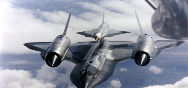
What looks like something famous, is much smaller, and is embroiled in a web of cold war cloak-and-dagger intrigue? It sounds like the answer could be Mini-Me from the Austin Powers movies, but we were actually thinking of the D-21 supersonic spy drone. Never heard of it? It didn’t have a very long service life, but it was a tiny little unmanned SR-71 and is part of a spy story that would fit right in with James Bond, if not Austin Powers.

The little plane had a wingspan of only 19 feet — compared to the SR-71’s 56 foot span — and was 42 feet long. It could fly at about Mach 3.3 at 95,000 feet and had a range of around 3,500 miles. It shared many characteristics with its big brother including the use of titanium and a design to present a low RADAR cross-section.

The Spy Who Photographed Me

With today’s global economy and increased international cooperation, it is hard to remember just how tense the late 1960s were. Governments wanted to see what other governments were up to. Satellite technology would eventually fill that role, but even though spy satellites first appeared in 1959, they used film that had to be retrieved by an airplane as it fell from the sky and then processed. Not exactly real time. More effective satellites would have to wait for better imaging technology — see the video below for just how bad those old satellite images were. That left spy planes to do the bulk of the work.

Continue reading “Spy Tech: Tiny Spy Plane Becomes Cold War Prize”