The Starlink beta has semi-officially ended, but it seems as though the global chip shortage is still limiting how many satellites are flying around the world for broadband internet access for those that might not be served by traditional ISPs. Not every location around the world has coverage even if you can get signed up, so to check that status the hard way you can always build a special antenna that tracks the Starlink beacons as they pass overhead.
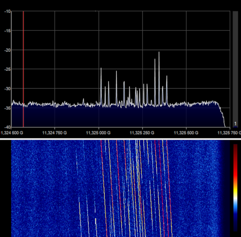
[Derek] is using this project to show of some of his software-defined radio skills, so this will require an SDR that can receive in the 1600 MHz range. It also requires a power injector to power the satellite receiver, but these are common enough since they are used to power TV antennas. The signals coming from the Starlink satellites have a very high signal-to-noise ratio so [Derek] didn’t even need a dish to focus the signals. This also helped because the antenna he is using was able to see a much wider area as a result. Once everything was set up and the computer was monitoring the correct location in the spectrum, he was able to see very clearly how often a satellite passed him by.
Of course, [Derek] lives in an area with excellent coverage so this might be a little more difficult for those in rural areas, but possibly not for long as the goal of Starlink is to bring broadband to people who otherwise wouldn’t have access to it. There is some issue with how much these satellites might interfere with other astronomical activities though, so take that with a grain of salt.
Thanks to [Spritle] for the tip!


I don’t know what Starlink’s constellation looks like right now, so this is just conjecture.
For any communications satellite constellation, for it to be useful before the constellation is complete, you want to launch satellites in a pattern that covers as much of the sky as possible, leaving later launches for filling in gaps between existing satellites. I see no reason why SpaceX would take any other approach. Since the satellites are in highly inclined orbits, to maximize the latitude range covered, these will move in longitude on every pass. Thus, there is no way to target satellites for different longitudes. If SpaceX wanted to cover as much area as possible, the first satellites launched would be at the highest inclinations, if their constellation uses multiple inclinations. Lower inclinations would be added later to provide more service to more populated latitudes, as the higher-latitude need was adequately served.
So there’s really no point to this project, aside from just proving that you can do it. Which is a good enough reason by itself, so why do the “do I have coverage here, and if so, how often?”
“!(Kessler syndrome)” detector would be a cooler project name
“I see no reason why SpaceX would take any other approach.”
Well here’s a reason: the vast majority of the US population is located on the east and west coasts.
Here’s another: with smaller gaps you don’t need to have a perfectly clear view of the sky to have continuous coverage.
Don’t quit your day job.
You may be aware that quite a few people actually live outside the US. Although to be fair, most of us have better broadband connections than the US average, so we’re not all inside the target audience for Starlink.
Also, the people on the east and west coast are probably reasonably well connected compared to the inland population, and if you have other options, those will probably be cheaper for the time being. Starlink routers also seem to be very power-hungry, which drives up the cost further.
The way you speak down to people and US centric thinking of a project that literally circulates the globe really makes you sound like an ass.
Don’t join my day job.
I see I was not clear enough. These are highly inclined LOW EARTH orbits. They are not geosynchronous. Each satellite passes a different part of the planet on each orbit. It is not possible for them to serve a specific place on Earth. The only coverage restrictions are the maximum and minimum latitude each satellite can serve, which is directly dependent on its inclination. This is very basic orbital dynamics.
And even if they COULD just magically hover over one spot, why would they target areas that already have easy Internet access cheaper than Starlink’s?
I quit my day job years ago. I feel much better. You should try it.
Stupid WordPress. This was meant for Kay.
No it wasn’t, it was meant for Gravis. I’m going back to sleep now.
So it’s like when Oscar6 went up. 20 minutes today at noon, some other time tomorrow, and maybe not within range the next day. You needed a computer to keep track, but since it was 1972, you needed someone else to run the program, and send the results as a bulletin.
So to get around that, Starlink launches a bunch of satellites,hooing to fill in the gaps. Nothing discriminatory.
There is one geosynchronkus ham satellite in orbit, and ne ercomes in range for North America. Its orbit “discriminates”.
Yes, Michael, very much like that. But the use of low-Earth-orbit for real-time communications isn’t just to fill in the gaps:
1) Geosynchronous orbits are very congested, because there is just one circle on which all geosync satellites have to sit, and it’s pretty close to full at this point.
2) Geosync orbit is very high, like 35.8Mm above sea level (I don’t use thousands of km; that’s what metric is for – they are megameters), so the minimum round-trip time is 70Mm/(300Mm/sec) = about a quarter of a second (longer if you’re not directly under the satellite), which throws off normal human interactions. Bell Telephone did some tests to see if this kind of delay was acceptable to users, and had to reject the idea of geosync telephone relay satellites.
3) Even though they are very high, they’re not so high that the EARTH doesn’t shadow them from ground stations at very high or very low latitudes. Anybody north of 80deg or south of -80deg latitude can’t get HBO. Admittedly, this doesn’t exclude a large population.
4) The high orbits mean that transmitters both on the satellites and the ground stations have to be powerful, or have large antennas. Not a good thing for portable devices.
Starlink’s current authorization from the FCC has satellites are in four different inclinations, 53.0, 53.2, 70, and 97 degrees. Why so many? Mainly because most of the people in the world are within coverage of the 53 degree orbits, while the 70 and 97 degree orbits provide sufficient coverage for the far fewer people at latitudes beyond what those can cover. I’m guessing that the 53.2 degree orbits are there to fill gaps that may appear in the 53.0 degree orbits alone. So yeah, there is more priority placed on reaching more people, but this doesn’t mean that people in Antarctica will have to wait for a satellite to show up; it just means there is less total bandwidth available per unit area. As of the latest authorizations, there are over 500 satellites in the 97 degree orbits alone, so I don’t think anyone is going to be under-served.
I was lucky enough to look up from my driveway a couple days after a Starlink launch, just in time to see sixty bright spots, about a second apart from each other, marching across the sky. Take THAT, flat-Earthers.
Please see my reply below, which was nicely mis-placed by WordPress.
Which is actually above. I’m going to look for a day job now.
Astrophotography will also tell you. Although you don’t know what type of satellite is whizzing by, but I’ve captured some pretty cool photos. You can see the solar panels and everything.
As far as I can make out the starlink coverage is currently limited by ground station coverage. They don’t have the fast space laser links working yet. So every connection is just hoping straight from the satellite to a high bandwidth ground station. Without a ground station in your coverage bubble it won’t work.
Im sure Musk is smart enough to figure it all out. Of course he’s not doing it the way it’s always been done BBJ…that’s the genius of the man. He’s already got my $99 deposit for our home here in the mountains of Bali!
Not quite sure what you are referring to with “not doing it the way it’s always been done”. Even Elon Musk isn’t clever enough to change how orbits work.