Figuring out what the Earth’s climate is going to do at any given point is a difficult task. To know how it will react to given events, you need to know what you’re working with. This requires an accurate model of everything from ocean currents to atmospheric heat absorption and the chemical and literal behavior of everything from cattle to humans to trees.
In the latter regard, scientists need to know how many trees we have to properly model the climate. This is key, as trees play a major role in the carbon cycle by turning carbon dioxide into oxygen plus wood. But how do you count trees at a continental scale? You’ll probably want to get yourself a nice satellite to do the job.
How Many Are There?!
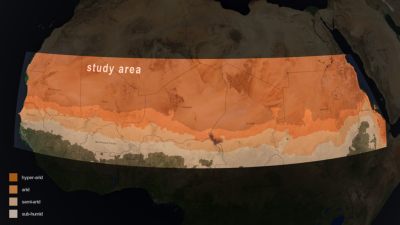
Thankfully, some of the bright minds over at NASA are on the job. In partnership with an international team of scientists, they have been mapping out trees across vast tracts of Africa. The aim of the project was to get an idea of just how much carbon is stored across Africa’s drylands, as opposed to the dense tropical rainforests in the region.
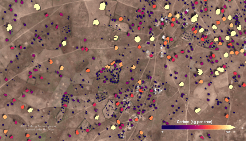
To count the tree populations across such a wide area, the team relied on high-resolution satellite imagery from commercial providers. Once the purview of governments only, now it’s easy enough to stump up some cash and get all the high-resolution space photography you could possibly imagine. The team sourced a dataset of 326,000 satellite images from the QuickBird-2, GeoEye1, WorldView-2, and Worldview-3 satellites, all run by Maxar Technologies. The images had a resolution of 50 centimeters, allowing for the identification of individual trees.
Researchers then used an artificial intelligence algorithm to count trees in the images. This model had to be trained first, of course. A sub-team at the University of Copenhagen was charged with this role, using data from 89,000 individual trees to teach the AI how to identify trees and their carbon content from satellite images. The model was taught to identify trees by their crown of green leaves, along with an adjacent shadow. The latter detail is key to differentiating a tree from a small shrub or grass sitting at ground level. The machine-learning model had its output tested by comparing it with human assessors, with the model proving to be 96.5% accurate compared with human measurements of tree-crown area.
Armed with the measurement of crown area, researchers can then extrapolate this with a statistical model to get an idea of how much carbon that given tree has stored. This statistical model was created by a group at the University of Toulouse, which assessed 30 unique tree species. By measuring the mass of leaves, wood, and roots, and comparing it to crown area, the team formed a model that could take crown measurements from satellite data and turn it into carbon storage figures. This took a great deal of work, involving going out to dig up and literally measure real trees in the field.
Speaking on the matter, lead scientist Compton Tucker noted this method has provided a far more accurate idea of carbon storage in the African drylands than was previously available. Earlier efforts had gotten confused between grass or shrubs and actual trees pictured in satellite images. “That led to over-predictions of the carbon there,” stated Tucker. In contrast, the researchers now had a much finer analysis. Our team gathered and analyzed carbon data down to the individual tree level across the vast semi-arid regions of Africa or elsewhere – something that had previously been done only on small, local scales,” said Tucker.
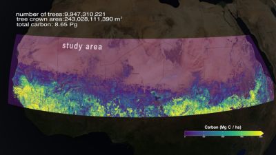
It might sound easy to simply download some satellite images, run an algorithm, and count some trees. The reality is far more complex. The scientists had to do plenty of work out in the real world to create the models that underpin this analysis. As a result, though, we now have a far better understanding of carbon storage across the drier parts of Africa. Researchers learned that while individual trees store somewhat less carbon than initially predicted, there are also a lot more trees out there than previously understood. The final estimate was that the trees of the African drylands store around 0.84 petagrams of carbon, or roughly 840 million metric tons. That’s approximately 926 million US tons, if you’re used to measuring continents worth of trees in imperial units.
The research team has openly shared its work, so you can read the full paper and dive into the data as you wish. This knowledge should help incrementally improve climate models for scientists around the world.


For comparison, at 400 ppm, Earth’s atmosphere contains 40 tons of carbon dioxide per hectare of land area. The study area shown is about 2000×6000 km = 1.2 B hectares.
So the atmosphere over that study area contains 48 billion tons of CO2, compared to the 0.8 billion tons of carbon in those trees that the study measured.
Burn *all* those trees and you’ll increase the CO2 in that portion of atmosphere by 6%.
So it’s pretty impressive that we have managed to increase the CO2 in the atmosphere by 50% in the last 150 years or so. Kudos humans.
Granted, the study area was mostly desert with zero trees. Seems like an odd spot to pick imo
It’s called cherry-picking data to reach a predetermined conclusion.
If I was going to compare the accuracy of my tree counting model against the accuracy of human assessors, I’d pick a desert/savanna biome too. I doubt that humans would be as accurate at counting trees somewhere like an actual forest. Especially when they could count trees that satellites might not see (underbrush).
There is probably already better data in more common and easier to reach environments or nicer places to be. Previous data for this area was bad, likely because no-one bothered to do the work with any accuracy before this.
Depends, if they were specifically trying to develop methods/algorithms to label trees, I can see it being a good starting point.
There’s probably better algorithms for the dense forest areas.
At least in Norway we have pretty good models. The reason for that is that we have a very good ground truth database from a project where forresting machines were fitted with rtk gps, so each tree was automatically geotagged when cut while the length/diameter was automatically measured by the forresting-machine. That gave thousands of very accurate datapoints with very little manual work (the machines would do the cut it down independent of of the project, so why not get some useful data?)
The entire purpose of the study is to train and test the models. In order to do that they needed to be able to isolate individual trees and their shadows, which requires sparse density. Hence the drylands. This effort is just one step of many towards developing more and more accurate methodologies and models for analyzing and understanding the role trees play in the carbon cycle. The fact that the remote sensing results are already so close to the results from people going into the field to take direct measurements is hugely impressive.
If you’re working at this scale, rather than metric or imperial units, the normal way is “as much carbon as an area of rainforest x times the size of Wales”.
I tried to use an online, AI based, service for tree counting and mapping of my property, it was useless. Unless you are working on a huge scale you are better off hand annotating aerial photograph mosaics from a drone based scan. If you can get multispectral data even better, it helps when you are mostly dealing with 1000 shades of green.
>But how do you count trees at a continental scale?
Well in Canada our governent decided to only count trees within 30km of metro areas then decided to call us carbon positive instead of a net carbon sink……