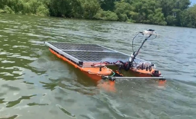
Although the types of drones currently dominating headlines tend to be airborne, whether it’s hobbyist quadcopters, autonomous delivery vehicles, or military craft, autonomous vehicles can take nearly any transportation method we can think of. [Clay Builds] has been hard at work on his drone which is actually an autonomous boat, which he uses to map the underwater topography of various lakes. In this video he takes us through the design and build process of this particular vehicle and then demonstrates it in action.
The boat itself takes inspiration from sailing catamarans, which have two hulls of equal size connected above the waterline, allowing for more stability and less drag than a standard single-hulled boat. This is [Clay]’s second autonomous boat, essentially a larger, more powerful version of one we featured before. Like the previous version, the hulls are connected with a solar panel and its support structure, which also provides the boat with electrical power and charges lithium-iron phosphate batteries in the hull. Steering is handled by two rudders with one on each hull, but it also employs differential steering for situations where more precise turning is required. The boat carries a sonar-type device for measuring the water depth, which is housed in a more hydrodynamic 3d-printed enclosure to reduce its drag in the water, and it can follow a waypoint mission using a combination of GPS and compass readings.
Like any project of this sort, there was a lot of testing and design iteration that had to go into this build before it was truly seaworthy. The original steering mechanism was the weak point, with the initial design based on a belt connecting the two rudders that would occasionally skip. But after a bit of testing and ironing out these kinks, the solar boat is on its way to measure the water’s depths. The project’s code as well as some of the data can be found on the project’s GitHub page, and if you’re looking for something more human-sized take a look at this solar-powered kayak instead.


Here in Arizona the bottom contour of many of the lake bottoms was determined from the topo maps that were generated before the canyons were dammed up. And the maps often can be at least partially verified when they periodically dry up.
;)
Same around here. Reservoir topo maps like to pretend that it’s still a pristine, sharp river valley down there and not seventy years of silt
A very cool invention, people are creating more and more autonomous structures that can work without human intervention, how our lives will change after 50 years
44 minute video and not a single map of the bottom that I could find.
Rule #1 of builds – results first THEN show the build.
i won’t be watching a youtube video, naturally
this just reminds me of a thing i run into every time i think about building robots
it’s a neat idea and remarkably autonomous but you know it’s gonna get snagged on this and that. it’ll be an upside down bug on the sidewalk, waving its legs in the air and surviving only if an ape happens to come along and flip it over before a bird comes along to eat it.
a real bummer for the whole idea of a precision remote operated instrument. almost every machine — especially if it has to leave the lab — has to periodically accept the fingers of a technician, just to unjam it.
on my mind because buried utility lines sigh