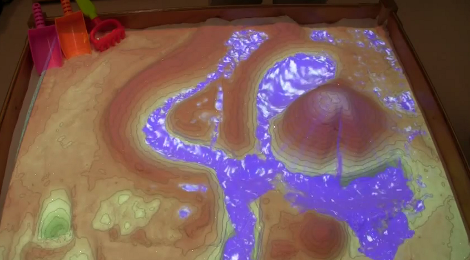
Laser Cut Map Taken To The Next Level

For Christmas this year, [Scottshambaugh] decided to make his family a map of their hometown — Portland, ME. Using topographical map data, he made this jaw-dropping 3D map, and it looks amazing.

He started by exporting the elevation data of Portland using software called QGIS, a free opensource geographical information system — it’s extremely powerful software, but takes a bit to learn. Luckily, [Scott] made a tutorial for us. All you need to do is add the road data, put all the slices into an illustrator file, clean up some of the files, and you’re ready to start laser cutting.

He used 1/8th thick sheets of Baltic birch plywood, a staple material around laser cutters because it burns quickly and easily and is very flexible, which means that it’s harder to break. The map measures 12″ x 24″ — but once it’s laser cut, be ready for a multi-leveled jigsaw puzzle! The small pieces of elevation data can be very tricky!

Continue reading “Laser Cut Map Taken To The Next Level”

Laser Cutting Bathymetric Maps

Bathymetry is the underwater equivalent to topography. And with the right map data, you can make some amazing 3D laser cut maps that feature both land masses — and the details under the sea. [Logan] just learned how to do this, and is sharing his knowledge with us.

[Logan] holds the typical hacker belief: The best way to learn something is just to start the project and figure it out as you go. Which also makes him an excellent candidate for helping others to learn what not to do. His goal of the project was to create a visually stunning map of Vancouver that helps to emphasize the depth of the ocean just off the coast.

To do this he obtained bathymetry data from the Fisheries and Oceans of Canada, and city map data from Open Street Map, a service we’re very familiar with that has provided data for many cool hacks, like this Runner’s GPS unit. The tricky part now is combining the data in order to laser it.

Continue reading “Laser Cutting Bathymetric Maps”

Paper Topo Models With Vector Cutter

If there’s a science fair coming up, this trumps just about any 2D poster. It’s a 3D topographical map of an inactive Slovakian volcano, Poľana. [Peter Vojtek] came up an easy way to generate SVG topo patterns using Ruby.

Topographical data is available through the MapQuest API. You should be able to model just about any part of the world, but areas with the greatest elevation difference are going to yield the most interesting results. The work starts by defining a rectangular area using map coordinates and deciding the number of steps (sheets of paper representing this rectangle). The data are then chopped up into tables for each slice, converted to SVG points, and a file is spit out for the blade cutting machine. Of course you could up the game and laser cut these from more substantial stock. If you have tips for laser-cutting paper without singing the edges let us know. We’ve mostly seen failure when trying that.

The red model explained in [Peter’s] writeup uses small cross-pieces to hold the slices. We like the look of the Blue model which incorporates those crosses in the elevation representation. He doesn’t explain that specifically but it should be easy to figure out — rotate the rectangle and perform the slicing a second time, right?

If you’re looking for more fun with topography we’ve always been fond of [Caroline’s] bathymetric book.

Retrotechtacular: The (Long, Arduous) Birth Of A Tank

Throughout the 1950s and early 1960s, the United States Army provided regular status reports to both its interior members and the American public through a half-hour documentary television show called The Big Picture. Since the program was produced by the government, every episode immediately entered the public domain. This particular report tells the story of the T-48 project that culminated in the 90mm M48 Patton tank.

The film opens by providing a brief history of tanks and the lessons learned about them between WWI and the Korean War. The Army sought a more robust vehicle that could handle a wide variety of climates and terrain, and so the process of information gathering began. After a series of meetings at the Pentagon in which all parties involved explored every facet, the project was approved, and a manila folder was officially designated to the project and labeled accordingly.

vesselsWe then tour the R&D facility where new tank materials and components are developed and tested. It is here that the drive gears are put through their paces on a torsion machine. Air cleaners are pitted against each other to decide which can filter out the finest dust and sand. After careful analysis, different tank shell materials are test welded together with various, well-documented electrodes, and these panels are taken outside so their welds can be directly fired upon.

Continue reading “Retrotechtacular: The (Long, Arduous) Birth Of A Tank”

Sandbox Topographical Play Gets A Big Resolution Boost

Here’s another virtual sandbox meets real sandbox project. A team at UC Davis is behind this depth-mapped and digitally projected sandbox environment. The physical sandbox uses fine-grained sand which serves nicely as a projection surface as well as a building medium. It includes a Kinect depth camera over head, and an offset digital projector to add the virtual layer. As you dig or build elevation in parts of the box, the depth camera changes the projected view to match in real-time. As you can see after the break, this starts with topographical data, but can also include enhancements like the water feature seen above.

It’s a big step forward in resolution compared to the project from which the team took inspiration. We have already seen this concept used as an interactive game. But we wonder about the potential of using this to quickly generate natural environments for digital gameplay. Just build up your topography in sand, jump into the video game and make sure it’s got the attributes you want, then start adding in trees and structures.

Don’t miss the video demo embedded after the break.

Continue reading “Sandbox Topographical Play Gets A Big Resolution Boost”