Maybe your goal is to preserve the heyday of rail travel with a precise scale replica of a particular railroad station. Maybe you’re making a hyper-local edition of Monopoly in which the houses and hotels are the actual houses and hotels in your hometown.
Whatever the reason, if you have need for shrinkifying a building or other reasonably large object, there is (at least) one sure-fire way to do it, and [ nastideplasy ] is your guide with this tutorial on drone photogrammetry.
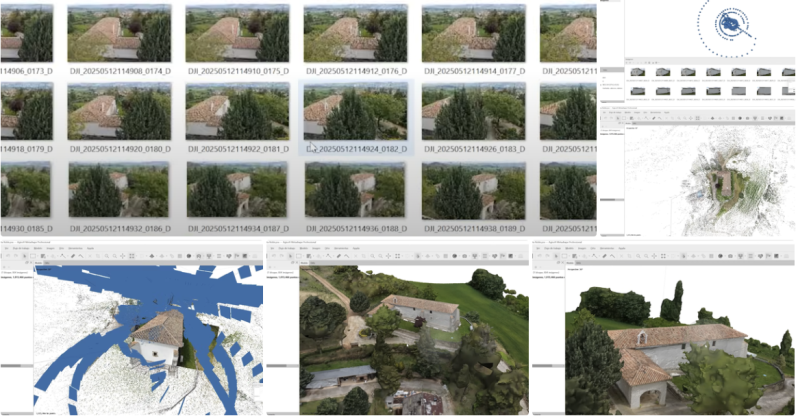
The process is essentially the same as any other photogrammetry you may have seen before—take lots of overlapping photos of an object from many different angles around it, stitch those photos together, make a 3D mesh by triangulating corresponding points from multiple photos—but this time the photos are captured by drone, allowing for much larger subjects, so long as you can safely and legally fly a drone around it.
The challenge, of course, is capturing a sufficient number of overlapping photos such that your reconstruction software can process them into a clean 3D mesh. Where purpose-built 3D scanners, automatic turntables, or a steady hand and lots of patience worked well at a smaller scale, skill with a pair of control sticks is the key to getting a good scan of a house.
[ nastideplasy ] also points out the importance of lighting. Direct sunlight and deep shadows can cause issues when processing the images, and doing this at night is almost certainly out of the question. Overcast days are your best bet for a clean scan.
The tutorial calls for software from Autodesk to stitch photos and clean up 3D meshes. We’ve also seen some excellent results with open source options like Meshroom as well.


AutoDesk Recap only offers full features for a month-long trial, then defaults to a limited free version; full version is super expensive. Better to use Reality Scan (https://www.realityscan.com/en-US), which is full-featured for anyone making less than $1 million in revenue, students and educators. Not a big fan of the interface, but it’s a lot better than Meshroom.
What about WebODM, the open source software developed for exactly this purpose?
Just a +1, WebODM worked like magic for me. Used it a few years ago to make a 3d model of the front of my house using photos taken from ground level and from my neighbour’s house across the street. I suspect too many people think it’s drone only.
WebODM to create architectural survey, generating accurate facade ortho images is possible?
Autodesk should be shunned at all costs. These scumbags have done more to harm users, developers, and even musical artists through their precedent-setting licensing douchebaggery.
Thanks for posting this. I really wish Hackaday would apply some content filters beyond “is the end result neat?”
Yep, screw Autodesk. A hack using their products is even worse than a tech discussion on Discord/twitter. Fortunately the world is full of cool hacks and despite boycotting thw above, I have anever sat on the internet and said “hm, nobody has built anything cool this week.”
And as is often the case for Hackaday, there is gold to be found in these comments. Like the Blender addon linked below.
Hard to believe this topic never made it onto Hackaday before (it’s been a thing for more than 10 years). And especially now when flying drones is so restricted in most jurisdictions that this information won’t be useful for many anymore.
They have even done photogrammetry with the footage from that helicopter on Mars.
Epic RealityScan could be a possibility here as well.
https://www.realityscan.com/en-US/news/realityscan-20-new-release-brings-powerful-new-features-to-a-rebranded-realitycapture
I’ve used it successfully for other nerdly persuits and projects as well
https://hackaday.com/blog/?s=mdlougheed
Just a question, does google use this for google maps to get the 3d version of the map?
In case anyone’s wondering (and is too lazy to google it), yes google does use it
Soooo, if in a combat zone the suicide drones send the video back, and them are sent in waves, you can save all the footage, then you’ll get the 4d model of what you destoyed from untouched to rubble.
Just got the same ideea for all the nukes.
Who’s gonna sell the popcorn to the aliens after the show is recorded?
I am working on a Blender addon https://github.com/kyjohnso/skysplat_blender to do this will all free and open source software
I was just reading the project!!
Looks great!
I see the wish to have some testing done. I can dig into it in a few days and run some tests.
Excellent project!!
Photogrammetry takes to the skies, huh? I think you meant “back to the skies”. That’s kinda where it started… Lol!