The basic principle of radar systems is simple enough: send a radio signal out, and measure the time it takes for a reflection to return. Given the abundant sources of RF signals – television signals, radio stations, cellular carriers, even Wi-Fi – that surround most of us, it’s not even necessary to transmit your own signal. This is the premise of passive radar, which uses passive RF illumination to form an image. The RF signal doesn’t even need to come from a terrestrial source, as [Jean Michel Friedt] demonstrated with a passive radar illuminated by the NISAR radar-imaging satellite (pre-print paper).
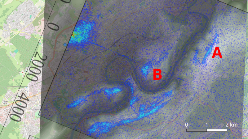
NISAR is a synthetic-aperture radar satellite jointly built by NASA and ISRO, and it completes a pass over the world every twelve days. It uses an L-band chirp radar signal, which can be picked up with GNSS antennas. One antenna points up towards the satellite, and has a ground plane blocking the signal from directly reaching the second antenna, which picks up reflections from the landscape under observation. Since the satellite would illuminate the scene for less than a minute, [Jean-Michel] had to predict the moment of peak intensity, and achieved an accuracy of about three seconds.
The signals themselves were recorded with an SDR and a Raspberry Pi. High-end, high-resolution SDRs such as the Ettus B210 gave the best results, but an inexpensive homebuilt MAX2771-based SDR also produced recognizable images. This setup won’t be providing any particularly detailed images, but it did accurately show the contours of the local geography – quite a good result for such a simple setup.
If you’re more interested in tracking aircraft than surveying landscapes, check out this ADS-B-synchronized passive radar system. Although passive radar doesn’t require a transmitter license, that doesn’t mean it’s free from legal issues, as the KrakenSDR team can testify.


Pretty interesting!
I had recently been wondering about the possibility of doing something similar for weather radar, utilizing the transmissions of a local radar with a user-owned receiver.
This suggests that it could be doable, although it’s far outside of my skillset unfortunately!
Since the weather radar will probably be static, you would need to move the receiver (in this demonstration, the receiver is static and the satellite emitter is moving) to get azimuth information. But definitely doable, although weather RADAR will be in the X-band most probably (8-12 GHz) and require some external frequency transposition to reach the SDR carrier frequency range.
“One antenna points up towards the satellite, and has a ground plane blocking the signal from directly reaching the second antenna, which picks up reflections from the landscape under observation.”
You don’t even need the second antenna: the signal you receive is the sum of the original and the reflected, you know where the satellite is, and you know how long the delay is, and so you autocorrelate the signal on that timescale. In radio astronomy this is a sea-cliff interferometer – there are experiments to use this to measure stuff like snowfall, atmospheric behavior, etc.
Indeed the strong reference signal leaking in the surveillance can be used. Actually this strong “interference” is usually rejected in passive RADAR using the Direct Signal Interference (DSI) cancellation since the autocorrelation of most waveforms will not be a Dirac function and leak in neighbouring bins, preventing short range target detection. However, for a few measurements, I had mis-connected the reference antenna on the B210 receiver and only collected the surveillance channel. I did autocorrelate to save a bit of data from these recordings: I just uploaded https://github.com/jmfriedt/NISAR_pbr/tree/main/260211_ENSMM_trepied_wrong_antenna with some poorer SNR and artifacts from the targets autocorrelating with each other, but nevertheless the reflectors are indeed visible.
Yeah, the advantage of a single antenna system is pretty big for satellite experiments and it’s also helpful for controlling antenna factors. There’s a constellation of military satellites (MUOS) that are interferers on an experiment I’m on and a number of other satellites use them as signals of opportunity for weather observations.