Team Tahmo has a plan to put a network of 20,000 weather stations across sub-Saharan Africa. That’s an impressive goal, and already they have pilot stations in Senegal, Chad, Nigeria, Uganda, and South Africa. For their Hackaday Prize entry, they thought it would make sense to add more advanced sensors to their weather stations, and came up with GPS, lightning, and large scale soil moisture sensors.
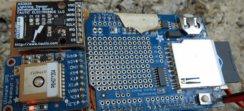
The sensors already deployed have the usual complement of meteorological equipment – thermometers, anemometers, barometers, and rain gauges. These stations are connected to a school’s Internet connection where students can monitor the local weather patterns and upload the data. Team Tahmo is building a small add-on board for their Prize entry using an AS3935 Franklin Lightning sensor and a GPS module.
In the interests of rapid design cycles, the team is using off-the-shelf modules for the lightning detector and GPS module. They hit up the Hackaday Prize Collabratorium for some advice on PCB design and have everything pretty much nailed down thanks to a few helpful hackers.
It’s a great project for one of the most ambitious crowdsourced data gathering projects ever conceived, and something that would vastly improve weather predictions across the African continent. Even if their entry does just monitor lightning strikes, it’s still an admirable goal and one of the most useful projects for this year’s Hackaday Prize.


What about including a camera pointed straight up, giving you what weather satellites give you, only from the opposite perspective. Satellite stations could forward this to a base station, which would stitch the images together, and you would be able to achieve a similar picture as the multi-million-dollar weather satellites do.
That sounds pretty hard to maintain, expensive, and bandwidth-heavy…
With that high number of stations, reverse camera is a great idea!
Also thunder activity is pretty decently covered since some station can pick up thuner form 2000miles away, (check http://www.blitzortung.org )
Our ANCIENT polar orbiting cloud sats send analog “TV” continuously. ANYBODY can receive and display it easily. Data carrier is approx. 174 MHz and small scanners or little aircraft receivers work fine. Bent coat hanger a fine ant. Line scan is a point camera on a rotating “cigar” satellite Data is AM 2400Hz tone running into a PC sound card record input. Surely still easy to find on ‘net.
hmm too bad this board is “retired” https://www.tindie.com/products/TAUTIC/as3935-lightning-sensor-board/ but lucly there is similar one from http://www.mikroe.com/click/thunder/
Having used both the AS3935 and also running a Blitzortung Station, I can tell you that you’ll run into issues with the AS3935. It’s not time accurate, so forget using them to triangulate strikes, and when you hook up to any kind of power supply it will stop working, it will still work demo but not with real strikes. AS3935 can only be run battery powered and most of the software that runs it is broken to boot.
The AS3935 is not without its issues but we have had a nice proof of concept around Nairobi. Have a look at http://eserver.kabarak.ac.ke/ojs/index.php/journal1/article/view/28/9. It suffices for the trilateration to be ‘close enough’ so a stroke can be identified as unique.
Sorry, noticed this link is not always (always not?) working, so here a shortcut: http://www.tahmo.org/132_Gilbert_Lightning.pdf
There’s sensor variance, psu variance location and obstacle variance plus the variance in time for the ID of a strike between different sensors and the antenna null. Then there’s also the issue that you’re only good to 40km plus if you’re supplied by 240V, you’re missing many of the strikes. Sure you can tell if a storm is approaching or not (to some degree), but not very well. I have a few AS3935 installs, but they are just for basic notification of a storm somewhere in the area, they’re not really good enough for anything else.
BO however is good, you’re talking 1km strike accuracy with 3-4 other stations, you could likely just setup 1 BO station to get coverage out to about 5000km by combining with others already monitoring. Once you have a station, you get access to the DB containing all strike information, also the implementation would be overall cheaper for 20,000 stations. You know exactly where the strike was and the trajectory of the storm. I’m regularly detecting strokes in the other hemisphere of the world.
We will definitely look into Blitzortung. Brilliant map at http://www.blitzortung.org/Webpages/index.php?lang=en! Plse note we are using the AS3935 (run on 5V DC) in a network, which also gives us 1-2km accuracy. We do not use the AS3935 distance estimate, which is based on the assumption that every stroke has about the same amount of energy, whereas energy varies an order of magnitude from one stroke to the next. At the moment, there is one BO station in Africa so we should definitely get some more stations out there at places where we have a bit more infrastructure & power.
Update: We are presently installing ten BlitzOrtung stations around Lake Victoria. There are some software issues that we have not yet been able to fix.
Any reason the GPS needs to be a part of the day to day operation?
Otherwise, fix its location with separate GPS device. (saving unit power and cost).
Is the lightning detector just an AM receiver capturing spikes in the static?
It probably doesn’t need to be on constantly but using it to help keep time accurately would help triangulating where the lightning strikes were when many receivers pick it up. I think doing say, 8 updates a day would probably keep the time close enough to get strike locations really nicely.
You want to triangulate the lightning strikes, how do you cheaply, yet accurately synchronize the clocks?
That is indeed why we include the GPS. Most of the time, it will not be on, only when storms are in the neighborhood. We are also thinking about using the zenith wet delay of the GPS to estimate precipitable water vapor in the atmosphere, although we do not focus on that during this Hackaday project. Another advantage of having a GPS on board is that it makes the station easier to find when stolen…. hasn’t happend yet, fingers crossed.
This is an ambitious undertaking and if successful will give useful information about spatial distribution of climate parameters. I am however missing the most important information about the sustainability of this project: how long will those thousands of stations be supported and maintained?
The TAHMO initiative is not covered by this Hackaday project and is, indeed, ambitious. Please have a look at tahmo.org to see what we do to make this a success by using innovative technology, education, and business. Everybody along the data & value chain will have to profit, one way or another, in order to make this sustainable. We use robust low maintenance stations, place them at schools for educational purposes and social protection, and sell data for commercial use, such as insurance, credit & input providers, to ensure financial sustainability.
The Hackaday Team_TAHMO project focuses on adding lightning information, especially around towns and lakes, to improve information on extreme weather. The aim is to have a $200 (now) to $50 (later) add-on to our standard weather station.