If you are a flier of a multirotor, or drone, you should be painfully aware of the regulations surrounding them wherever you live, as well as the misinformation and sometime bizarre levels of hysteria from uninformed people over their use.
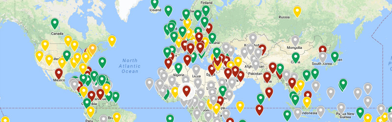
Should you travel with your drone, you will also probably be resigned to being interrogated by airport staff high on The War On Terror security theatre, and you’ll probably not find it surprising that they have little idea of the laws and regulations over which they have pulled you aside. It’s a confusing situation, and it’s one that [Anil Polat] has addressed by collating information about drone laws worldwide, and presenting his results on a Google map.
To do this must have been a huge undertaking, particularly since he got in touch with the appropriate authorities to access the information from the horse’s mouth. Looking at the map, we can almost view the green, yellow, and red pins showing different levels of restriction on flight as a fascinating indication of differing levels of security paranoia worldwide. If your territory has an orange or red pin, our commiseration.
This is a useful resource for anyone with an interest in multirotor flying, and he has also made it available as an app. However, it is always safest to check with the authorities concerned before flying in another territory, in case any laws have changed.
Here at Hackaday we’ve held an interest in the interface between multirotor fliers, governments, and the general public for a while now. In 2015 we took a look at FAA regulations for example, and last year we examined the inaccuracies in British air incident reports.
Via Adafruit.


That is almost useless as most country’s laws are applied differently according to complex zone boundaries. Australia has a much better system for people to know exactly what they can do in any given location. I expect many other countries also have similar systems and that is what people need to know about.
https://casa.dronecomplier.com/external
Same map for French :
https://www.geoportail.gouv.fr/donnees/restrictions-pour-drones-de-loisir
Close to useless.
Trying to fly in The Spit, Gold Coast City, Queensland.
All I get:
YHLW:HOLLYWELL
AIRPORT Lat:-27.9000, Long:153.4167
There is limited information about this airport.
It may be used regularly or sporadically, so before flying your drone here,
contact the aairport owner/operator about possible manned aircraft flying here.
Fly with caution and do not create a hazard to manned aircraft.
Looks pretty but is close to useless.
@Dan : that is a pretty damn awesome site. It could not be more clear as to what the zones are and where they are.
@Lufo : Yeah I get it that some “airports” come up with this message, but would you just prefer a red ‘no fly under any circumstances zone’ or something that gives you some freedom if you’re willing to do some legwork?
Would not necessarily call it paranoia, I mean we know ISIS for instance is actively using drones and we know various military uses small spy drones. So in some areas of the world there is a real reason.
And in Europe they had those weird drones conmstantly targetting nuclear power plants. I wonder if they ever found out what that was about.
I suspect these laws are somewhat due to an ill eagle.
My neighbor got one of those citations for his quadcopter at altitude too close to the airport and high enough above his yard to get the attention of authorities. The report of his ticket is online, public. He chilled it for almost a year. Now he’s out there with a schoolyard scale plane. Kicker is when I need to fly somewhere I pack my luggage and walk over to the airport with it, it’s that close. Light aircraft go over at 500 or 700 AGL on climbout. We’re about a block from the terminal, and the control tower is block and a half, and runways are other side of the terminal short ways.
Nope… they don’t learn. Tickets aren’t working.
If you are in Australia, you could also download the “Safe to Fly” app from the iOS App Store. Not sure if its available on Android… maybe somebody else could check?
Freedom. Everywhere freedom. Of course all for our safety :)
Frankly the Map and the Article is wrong on a lot of the points. Arizona has no restrictions, or registration, other than standard federal rules and laws about airports, and military bases. Other than that that one alone is wrong. i do know texas doesn’t have any laws according to drones, cause in texas it doest matter, they will just shoot your drone down period and there isnt a damn thing anyone can do about it if it is above YOUR land. You land extended 500ft above your ground plane…in the air space in texas. SO. It is similar to Az as well, Iirc it is 250ft above your ground plane i ahve to look at my land paperwork…but if a drone can go above 250ft all the more power to it, wont get crap for pictures though. and if a drone can go 500ft it wont do much good either for what it is supposed to do anyways.