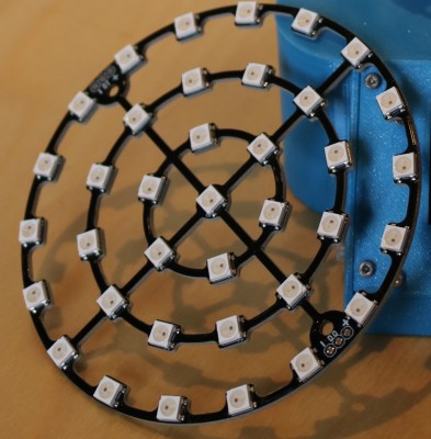
Whilst modern technology relies heavily on satellites, it’s easy to forget they’re there; after all, it’s hard to comprehend mostly-invisible lumps of high-density tech whizzing around above you at ludicrous speeds. Of course, it’s not hard to comprehend if you’ve built a real-time satellite tracker which displays exactly what’s in orbit above your head at any given time. [Paul Klinger]’s creation shows the position of satellites passing through a cylinder of 200 km radius above the tracker.

Each layer of LEDs represents a specific band of altitude, whilst the colour of the LEDs and text on the screen represent the type of object. The LEDs themselves are good old WS2812b modules, soldered to a custom PCB and mounted in a 3D-printed stand. The whole thing is a really clean build and looks great – you can see it in action in the video after the break
On the software side, a Raspberry Pi is in charge, running Python which makes use of pyorbital for some of the heavy lifting. The data is taken from space-track.org, who provide a handy API. All the code is on the project GitHub, which also includes the 3D print and PCB files.
[Paul] answers questions in the reddit thread, and gives more detail in this reddit comment. The project was inspired by one of our favorite sites: stuffin.space.
Some of the satellites the device displays are de-commisioned and inactive. Space junk is a significant problem, one which can only be tackled by a space garbage truck.


Hmm, nice idea and well done – could also use similar paradigm to display magnetic field changes above ground, such as mount it on wheels with sensitive detector close to ground, watch the leds change in relation to ore body influence :-)
How about a pigeon tracker so we’ll know when not to look up? :-D
B^)
LoL, well in those areas where there were no pidgeons or any flying things for that matter that we noticed we were more focused on things underfoot down 1-2 metres or so – though I concede the probability of dust in yer eyes might have been an issue such as from meteorite dust when looking up since it wasn’t considered zero likelihood…
I totally just noticed this post. Interesting bird alarm potential… I’m sure the concept can be modified for whatever purpose like birdies or perimeter activity. Neat system. The link below video seems great too.
When I took up amateur astronomy a few years back, I was surprised the first few times a satellite crossed in front of my view. I soon found that this is a common occurrence. There is a lot of junk up there.
Car up there somewhere. :-)
It’s not really tracking them, it’s reporting them based on data supplied by the user. In the same sense a phone book tracks telephones.
While this is really cool, I still absolutely love Practical Engineering’s ISS tracker.
https://www.youtube.com/watch?v=sIE0mcOGnms