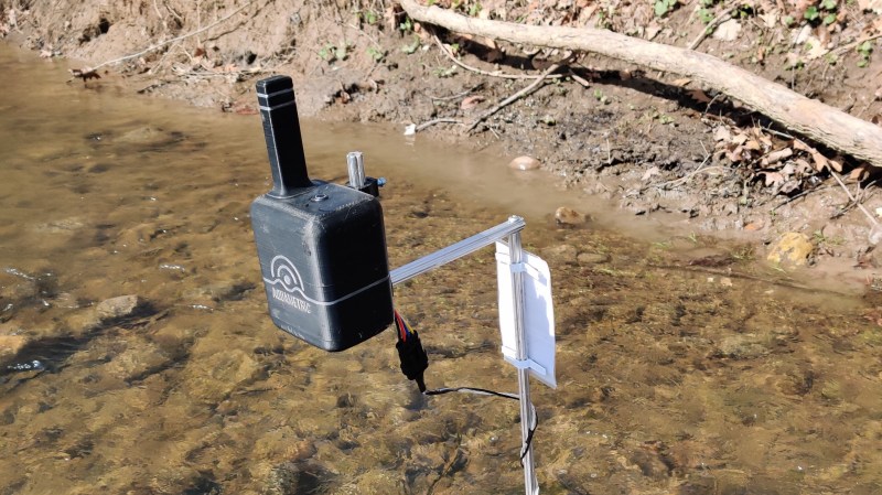
Small waterways give life in the form of drinking and irrigation water, but can also be very destructive when flooding occurs. In the US, monitoring of these waterways is done by mainly by the USGS, with accurate but expensive monitoring stations. This means that there is a limit to how many monitoring stations can be deployed. In an effort to come up with a more cost-efficient monitoring solution, [Rohan Menon] and [Ian Vernooy] created Aquametric, a simple water level, temperature and conductivity measuring station.
The device is built around a Particle Electron that features a STM32 microcontroller and a 3G modem. An automotive ultrasonic sensors measures water level, a thermistor measures temperature and a pair of parallel aluminum plates are used to measure conductivity. All the data from the prototype is output to a live dashboard. The biggest challenges for the system came with field deployment.
The great outdoors can be rather merciless with our ideas and electronic devices. [Rohan] and [Ian] did some tests with LoRa, but quickly found that the terrain severely limited the effective range. Power was another challenge, first testing with a solar panel and lithium battery. This proved unreliable especially at temperatures near freezing, so they decided to use 18 AA batteries instead and optimized power usage.
The mounting system is still an ongoing challenge. A metal pole driven into the riverbed at a wider part ended up bent (probably from ice sheets) and covered in debris to the point that it affected water level readings. They then moved to a narrower and shallower section in the hopes of avoiding debris, but the rocky bottom prevented them from effectively driving in a pole. So the mounted the pole on a steel plate which was then packet with rock to keep it in place. This too failed when it tipped over from rising water levels, submerging the entire sensor unit. Surprisingly it survived with only a little moisture getting inside.
For the 2020 Hackaday Prize, Field Ready and Conservation X Labs have issued challenges that need require some careful consideration and testing to build things that can survive the real world. So go forth and hack!


Suspend it from a bridge.
DOT is very testy about anyone attaching anything to their bridge piles.
There is a box with a solar panel attached to the guard rail of the highway bridge in my town.
I’m guessing it is for water depth or current speed.
Guard rails they probably aren’t so bad about. I’ve only dealt with them and the piles/foundations. We work with UNH sometimes and they had a heck of a time getting the DOT to let them put a small test turbine on the bridge (nice tidal flows there) God forbid we wanted to put one of our systems on it.
The other tricky part is there isn’t always a bridge where you want data.
Hwy 34 up to Estes Park, CO has a box attached to a bridge. I’m told it’s using radar to measure water level, river bottom level, and velocity of the Big Thompson River after destructive 2013 flooding.
We looked at this option, but unfortunately the height of the bridge put the sensor out of range of the water level and there were no piles that had a clear view of the water, but this option would definitely make sense with a higher range ultrasonic sensor.
It feels like anything that goes above the water line is asking for trouble. I wonder if there is a way to mount the whole thing on the bottom of the river (maybe embedded in one of those concrete deck footings) and do some sort of optical reflective widget to measure height. Or, by measuring the flow rate you might be able to derive the height.
Of course that limits your communications options a bit.
This actually sounds like a fun challenge.
I have several years of experience working on the water and in rivers with instrumentation and deployments as an engineer in free stream turbines and tidal turbines. My co-workers and I use the USGS data when we can, though I truly wish every site had a water velocity measurement, it would make finding good renewable energy sites much easier.
Water pressure for depth, that’s what is used in industry. Acoustic Doppler Current Profilers (ADCPs), use that plus an RTD (or thermister…possible) for getting the water properties to properly run the doppler profiling.
Communications you are essentially humped on. At shallow water depths you are stuck with running a cable to shore. Acoustic modems are hell in shallow waters and they have terribly low latency rates in practice anyway.
If you leave it on the bottom, you have to also concern yourself with how to recover it when it stops working, runs out of battery, needs an update etc. Recovery from the bottom of a river is not easy.
This of course assumes you have the requisite permits to do any of this, which is always a nightmare to do, for even the simplest things.
AT&T is phasing out 3G in February 2022
https://www.att.com/support/article/wireless/KM1324171
What about kinda ring,
with the sensor floating on the water and scanning the ground instead of the water surface?
(laser/ultrasonic?)
With some kind of cables/strings on rolls which could expand per springpower.
Like three at least, efficient maybe five?
Pentagonal ring, each corner inhibits a springroll with cables/strings to the center where the sensor is
placed in the water.
This pentagonal ring could be treated like other water-devices that are groundmounted?
Maybe weight anchored, but still the measurement tool needs to be mounted with the springrolls to ensure
sensor raising when the anchor chain is ‘maxed out’.
It would not be that accurate, because the level alters continuesly
but that would be just a small problem for blurring out the data and is just a task of adjustment?
(and it is not much different to the surface detection i suspect?)
Alu beams for the Pentagon, corners with rollholders / integrated holders 3d printed for the beams/with adapters for everything else that could be used as beams?
Recently our sensor was actually vandalized, so we’re looking into making a more discrete version that could sit under or just on the surface of the water. Thanks for the ideas.
Looks like some guy ropes would really help keeping it upright.
It’s a nice little project, but the difference between this and the type system the USGS or a commercial telemetry deployment would use is night and day.
The cost really isn’t the sensors, it is the network.
Whether 3G, 4G, 5G etc. cellular is only useful near populated areas. No matter what is shown on coverage maps, you don’t have coverage once you get more than a few miles from the freeways or generally where rivers are (and people aren’t) and cellular coverage isn’t really an option. If you are given a deployment of, say, 5,000 remote sites such as would be used in a mid sized telemetry deployment, and if using metered cellular service and multiple pool plans across multiple carriers because of coverage, you could have a monthly recurring network cost of $200,000 per month, but only if extreme effort is made to minimize the metered data throughput. (Such as limiting the number of polls, minimizing the data payload size and doing a full shutoff of LLC and other switching traffic, HELOs, and other non payload data traffic.) If one remote gets stuck in a loop, it can rack up a $10,000 per month bill for that site alone (in a pool plan).
I believe USGS uses their own satellite, but if a private satellite isn’t available, instead of cellular, a better option might be the SMS messaging feature on Inmarsat, which could be 1/4 the cost with coverage available everywhere on the globe (except the areas near the poles). In any case, proper network engineering is required to minimize throughput such as use of tiny payloads such as modbus packets.
Just spin it as “get schools into science and amateur radio” and get free labor and network operation. Pick frequency/power budgets that will carry to enough schools.
Absolutely. I’ve been intrigued with using this stuff with an ultra narrow band technology like PSK 32 and long range frequencies in HF. It could be a really cool experiment bed. If you didn’t mind a pseudo slotted aloha type reporting you could simply randomize the reporting timing, keep the data one way (in-route only) and just let them step on each other from time to time…..
Forget MRC, line of site, etc., hello ham radio.
18 AA cells? My old company built lithium battery powered tank level monitors using cellular powered by a single 3.6v C cell with an expected life of >6 years. Probably because we left the web page on a server and gathered data from the sites.
Surprisingly, most of NA has M2M coverage else we employed Globalstar with 2 year battery life.
Inmarsat, Globalstar and Iridium come to mind.
You wouldn’t believe how many remotes those 3 satellite systems cover. All provide “modem on board” modules which are right down the alley for hackaday fans. Probably cheapest is Inmarsat, but it depends on the number of remotes. Not talking about the wideband service, but a separate service based on polled SMS AKA M2M service which is typically not real time but responds within seconds to minutes.
I also thought: Why not use D cells when you need so much power?
We could definitely spend more time on reducing the power consumption of the device. We chose the Particle Electron initially for its ease of use, but we’re looking at cheaper and lower power microcontrollers. 3G is also a bit of a battery hog, so thanks for the tips. The web server is not based on the device, but it connects to it each hour so that we can do real time data.
Why would anyone use a Lithium battery for an outdoor application that get near freezing. They should have went with a lithium titanate battery. Second problem was they used a Particle Electron power hog. Should have used a ESP32 with a 3G modem.
Because Lithium batteries are among the best regarding cold temperatures. That does not mena LiIon battereis, but other lithium based chemistries e.g. LiFeS like Duracell or Energizer ultimate lithium (*) or LiSOCl2.
They also promise incredibly long shelf life, the 2 I have here, state 12/2038 as expiration date.
2038?
So, those batteries are affected by the UN*X clock rollover too?
B^)
What about Panasonic Eneloop NiMh cells, they look really dependable as well. even with low temperatures. And no under/over charge worries to speak off. So solar cell + diode is enough