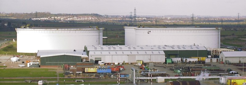
The global oil market plays a large role in the geopolitical arena, and it is often in the interest of various role players to conceal the figures on production, consumption and movement of oil. This may simply to be to gain an advantage at the negotiation tables, or to skirt around international sanctions. The website [TankerTrackers] is in the business of uncovering these details, often from open source intelligence. Using satellite imagery, they are using a simple way to monitor the occupancy crude oil storage facilities around the world.
The key is in the construction of large capacity crude oil storage tanks. To prevent the flammable gasses emitted by crude oil from collecting inside partially empty tanks, they have roofs that physically float on top of the oil, moving up and down inside the steel sides as the levels change. By looking at imagery from the large number of commercial satellites that constantly photograph earth’s surface, one can determine how full the tanks are by comparing the length of a shadow inside the tank to the shadow outside the tank. Of course, you also need to know the diameter and height of a tank. Diameter is easy, just use Google Earth’s ruler tool. Height is a bit more tricky, but can often be determined by just checking the facilities’ website for ground level photos of the tanks. Of course these methods won’t give you exact numbers, but it’s good enough for rough estimates.
Another interesting detail we found perusing the [TankerTrackers] news posts (requires sign-up) is that tankers will sometimes purposefully switch off their AIS transponders, especially when heading to and from sanctioned countries such as Venezuela and Iran. Even in today’s world of omnipresent tracking technologies, it’s surprisingly easy for a massive ship to just disappear. Sometimes [TankerTrackers] will then use imagery to track down these vessels, often by just watching ports.
Thanks for the tip [Arpad Toth]!
Photo by [Terryjoyce] CC BY-SA 3.0


There are companies that do this as a business from ground level as well – due to the construction of the tanks (as described in the article), thermal imaging is quite useful for this.
If someone is willing to pay for information, someone is willing to collect it to sell.
Turning “off” (shutting down) an AIS system while underway is a really dumb idea, as it removes an input to a ship’s navigational system – such as ECDIS or similar – for labeling a contact (or lack there of) on the radar displays. Putting an AIS in “Receive Only” mode limits this loss of situational awareness. There are certain types of ships that run with their AIS transponders in “receive only mode” as a matter of course.
So… those tanks are constantly off-gassing then? That’s nice. How much damage is that doing?
The floating roof is to stop the outgassing I think.
As far as I understand the article is not quite right about this. It is not open, the floating top is there in order to control pressure changes without having to eject gases through pressure valves. So the idea is actually to avoid having to eject gases into the environment (which would also be a major fire hazard).
https://www.slb.com/well-production/processing-and-separation/gas-treatment/natco-shv-combustor-internal-burner-emission-control-system
Cool stuff.
“Diameter is easy, just use Google Earth’s ruler tool. Height is a bit more tricky, but can often be determined by…”
…measuring the shadow of the tank v. the shadow of the roof float.
If the roofs float (which is sensible, I get that), what happens when it rains?
Either you have to have a big lip around the edge, and pump the water out over the edge of the tank, or you have to let it drain down through the oil, recover it at the bottom, then clean it enough to dump it out.
Either way, when a hurricane comes through Beaumont and dumps a foot of water in each tank (like, say, 4 times this year), what happens?
There are provisions for rain. I think it is a flexible hose that goes through the oil and to a flange near grade.
Things can go wrong if the drainage doesn’t happen. Too much water load and the roof can tip breaking the seal, releasing the contents to on top of the roof and substantially increasing the chance of a fire. It does happen and youtube can show you the fires though not usually the reason why.
Cleaning that drainage path is a far more important maintenance item than cleaning the gutters on your house.
I can’t find the video i wanted but here are some others you may like
https://www.youtube.com/user/USCSB/videos
complete with hokey animations