Watching The Global Oil Trade With Satellite Imagery

The global oil market plays a large role in the geopolitical arena, and it is often in the interest of various role players to conceal the figures on production, consumption and movement of oil. This may simply to be to gain an advantage at the negotiation tables, or to skirt around international sanctions. The website [TankerTrackers] is in the business of uncovering these details, often from open source intelligence. Using satellite imagery, they are using a simple way to monitor the occupancy crude oil storage facilities around the world.

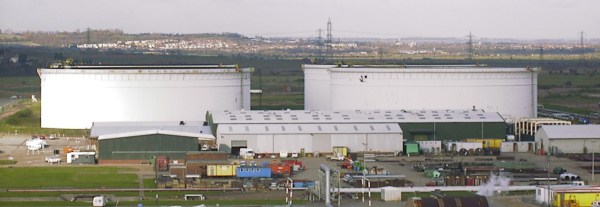
The key is in the construction of large capacity crude oil storage tanks. To prevent the flammable gasses emitted by crude oil from collecting inside partially empty tanks, they have roofs that physically float on top of the oil, moving up and down inside the steel sides as the levels change. By looking at imagery from the large number of commercial satellites that constantly photograph earth’s surface, one can determine how full the tanks are by comparing the length of a shadow inside the tank to the shadow outside the tank. Of course, you also need to know the diameter and height of a tank. Diameter is easy, just use Google Earth’s ruler tool. Height is a bit more tricky, but can often be determined by just checking the facilities’ website for ground level photos of the tanks. Of course these methods won’t give you exact numbers, but it’s good enough for rough estimates.

Another interesting detail we found perusing the [TankerTrackers] news posts (requires sign-up) is that tankers will sometimes purposefully switch off their AIS transponders, especially when heading to and from sanctioned countries such as Venezuela and Iran. Even in today’s world of omnipresent tracking technologies, it’s surprisingly easy for a massive ship to just disappear. Sometimes [TankerTrackers] will then use imagery to track down these vessels, often by just watching ports.

Thanks for the tip [Arpad Toth]!

Photo by [Terryjoyce] CC BY-SA 3.0

Microcontroller And IMU Team Up For Simple Flight Sim Controls

Classes are over at Cornell, and that means one thing: the students in [Bruce Land]’s microcontroller design course have submitted their final projects, many of which, like this flight control system for Google Earth’s flight simulator, find their way to the Hackaday tips line.

We actually got this tip several days ago, but since it revealed to us the previously unknown fact that Google Earth has a flight simulator mode, we’ve been somewhat distracted. Normally controlled by mouse and keyboard, [Sheila Balu] decided to give the sim a full set of flight controls to make it more realistic. The controls consist of a joystick with throttle, rudder pedals, and a small control panel with random switches. The whole thing is built of cardboard to keep costs down and to make the system easy to replicate. Interestingly, the joystick does not have the usual gimbals-mounted potentiometers to detect pitch and roll; rather, an IMU mounted on the top of the stick provides data on the stick position. All the controls talk to a PIC32, which sends the inputs over a serial cable to a Python script on the PC running Google Earth; the script simulates the mouse and keyboard commands needed to fly the sim. The video below shows [Sheila] taking an F-16 out for a spin, but despite being a pilot herself since age 16, she was curiously unable to land the fighter jet safely in a suburban neighborhood.

[Bruce]’s course looks like a blast, and [Sheila] clearly enjoyed it. We’re looking forward to the project dump, which last year included this billy-goat balancing Stewart platform, and a robotic ice cream topping applicator.

Continue reading “Microcontroller And IMU Team Up For Simple Flight Sim Controls”

We Declare The Grandmaster Of Pokemon Go GPS Cheats

Since Pokemon Go blew up the world a couple of weeks ago we’ve been trying to catch ’em all. Not the Pokemon; we’ve been trying to collect all the hardware hacks, and in particular the most complete GPS spoofing hack. We are now ready to declare the first Grandmaster GPS spoofing hack for Pokemon Go. It broadcasts fake GPS signals to your phone allowing the player to “walk around” the real world using a gaming joystick.

Just about everything about this looks right to us. They’re transmitting radio signals and are doing the responsible thing by using an RF shield box that includes a GPS antenna. Hardware setup means popping the phone inside and hooking up the signal generator and GPS evaluation hardware. Google Earth then becomes the navigation interface — a joystick allows for live player movements, coordinates are converted to GPS signals which are transmitted inside of the box.

Now, we did say “just about right”. First off, that RF shielding box isn’t going to stop your fake GPS signals when you leave the lid open (done so they can get at the phone’s touchscreen). That can probably be forgiven for the prototype version, but it’s that accelerometer data that is a bigger question mark.

When we looked at the previous SDR-based RF spoofing and the Xcode GPS cheats for Pokemon Go there were a number of people leaving comments that Niantic, the devs responsible for Pokemon Go, will eventually realize you’re cheating because accelerometer data doesn’t match up to the amount of GPS movement going on. What do you think? Is this app sophisticated enough to pick up on this type of RF hacking?

Continue reading “We Declare The Grandmaster Of Pokemon Go GPS Cheats”

Show A Quadcopter Flight On Google Earth For Under Ten Bucks

[Joop Brokking] wanted to know where his quadcopter was and had been. He thought about Google Earth, but assumed it would be difficult to get the GPS data and integrate it with Google’s imagery. But he discovered it was easier than he thought. He wound up spending around $10, although if his ‘copter didn’t already have GPS, it would have been more.

Hardware-wise, [Joop] made a pretty straightforward data logger using a small Arduino (a Pro Mini) and an SD Card (along with an SD breakout board). With this setup, NMEA data from the GPS comes in the Arduino’s serial port and winds up on the SD Card.

Continue reading “Show A Quadcopter Flight On Google Earth For Under Ten Bucks”

Virtual Segway Tours Using The Wii Balance Board

Take a tour of anywhere on earth without leaving your home. This virtual Segway tour uses the Wii Fit Balance Board and Google Earth to let the rider control a virtual tour by leaning in the direction they want to travel. It’s the product of a hackathon at SVI Hackspace, a new hackerspace in Stanford’s Huang Engineering Center.

The project was undertaken by four people who had just met for the first time that night. Seven hours later, they had a working system that combines a huge number of software packages; OS X, Osculator, Node.js, Socket.io, the Google Earth API, Monster Milk Truck, and Google 3D Warehouse. Most of those packages are used to get the board talking to the computer and then interpreting the data. Monster Milk Truck – which we had never heard of – is a plugin that lets you drive through Google Earth environments using button presses and arrows (which are simulated by the balance board data translations).

This is a nice complement to some of the other balance board hacks we’ve seen, like the one used to control World of Warcraft. Don’t forget to peek at the video after the break.

Continue reading “Virtual Segway Tours Using The Wii Balance Board”

More Bike-controlled Google-travelling

This is becoming such a popular hack we figure someone needs to come up with a name for it like Google-travelling or Google-cising (exercising with Google). It’s a bike controller for Google Earth. [Braingram] broke out his road bike, setting it up in the trainer in front of his laptop. If you already have a computer with a cadence sensor this will be a snap. These measure the crank rotation using a magnet and reed switch. So as not screw up his summer biking [Braingram] spliced into the sensor while leaving it attached to the bike computer. From there it is read by an Arduino which also monitors an analog joystick attached to the handlebars. A little bit of Python scripting and you’ll be ready to go.

Be sure to check out some of the other variants like using an exercise bike, or adding a wearable display.

Flight Simulator But You’re The Plane

[Rafael Mizrahi] built a flight simulator that lets him fly like Ironman. As you can see in the video after the break, the hardware involves an automotive crane, hang gliding harness, plus the wings and tail from a UAV. A giant fan pointed at the wearer allows him to use the wings and tail to maneuver while the Wii remote strapped to his chest tracks the movement and feeds it to Google Earth Flight Simulator which is seen through the head-mounted display. We’re used to seeing intense flight simulators but this is something completely different.

Continue reading “Flight Simulator But You’re The Plane”