It’s easy to take for granted the constantly-connected, GPS-equipped, navigation device most of us now carry in our pockets. Want to know how to get to that new restaurant you heard about? A few quick taps in Google Maps, and the optimal route given your chosen transportation method will be calculated in seconds. But if you ever find yourself lost in the woods, you might be in for a rude awakening. With no cell signal and a rapidly dwindling battery, that fancy smartphone can quickly end up being about as useful as a rock.
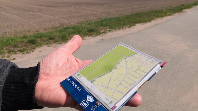
Enter the IndiaNavi, a modernization of the classic paper map that’s specifically designed to avoid the pitfalls that keeps your garden variety smartphone from being a reliable bushcraft tool. The color electronic paper display not only keeps the energy consumption low, but has unbeatable daylight readability. No signal? No problem, as the relevant maps are pre-loaded on the device.
Besides the 5.65 inch e-paper display from Waveshare, the India Navi features a L96 M33 GPS receiver and ESP32-WROOM-32 microcontroller. The 3D printed enclosure that holds the electronics and the lithium pouch battery that powers them is still in the early stages, but we like the book-style design. The focus on simplicity and reliability doesn’t end with the hardware, either. The software is about a straightforward as it gets: just boot the IndiaNavi and you’re presented with a map that shows your current position.
With the rise of easily hackable e-paper displays, we’re excited to see more concepts like the IndiaNavi which challenge our ideas on how modern electronics have to function and be used.


The only thing it’s missing to be a critical piece of survival gear is some solar cells and to be ruggedized.
Perhaps a battery warming function, otherwise cold will kill your map as fast as it kills your smartphone….
Put the battery on a lead long enough to go down your sleeve and you can keep it somewhere warm while you look at the map.
I hope they are also testing the main electronics at -18C too.
Nah just fit a crank handle – make you crank for the two mins or so it will take to acquire and update the screen, who needs batteries…
My first thought too.
What about à solar cell at the back? Put 2 clip on the casing to fix it when not need for example at the back of the backpack? Or make a sleeve on the arm to put it for readings and then Flip to the cell when not needed?
The title is wrong (again) :
ANY (basic, cheap, Andoidp) hone can have -free- offline maps. Way cheaper than a fancy color e-paper. And has much more use cases than just a map. Which for India might be quite relevant
Few days ago my father was looking for some place in middle of the city. He wanted to use google maps but due to sunlight his phone was completly unreadable. And that was Samsung not some cheapest crapscreen.
It’s not for India! The name is a pun on Indiana Jones!! Check out the pictures on the project page, the logo for IndiaNavi is clearly inspired from the logo of the movies.
They really should have gone for IndianaNavi. It makes a lot more sense.
Yep, and the free software makes the battery last forever … ohh wait!
min lasts almost one week on a load. with around 1h of Wifi use per day, GPS with offline maps and bluetooth on for 3h a day, LTE permanently on.
It´s just a basic Huawei model but it stripped it off most of its apps, and replaced with open-source apps providing the same functionality from F-Droid repository. There is waaaaay less processes running and almost no network packets exchanged when not browsing, and this results in a very long autonomy.
Closed-sources app doing whatever evil they want in the background, using way more memory than needed their core task, with outreaching permissions to anything are THE real clutter. Then you need some other apps to force them to sleep, and overall you get a mess.
Yeah, and how long is the battery going to last? Even with the radios off, you’d be lucky to get 24 hours. We won’t even talk about daylight readability, or the fact you’ve got to keep turning it on to actually see the screen.
There’s a reason Amazon is selling millions of Kindles every year, even though everyone’s already got a smartphone in their pocket.
Now that you said it I wonder why noone thought about maps for e-readers.
Its definitely not been missed, we have seen folks repurposing kindles for their bike etc.
But e-readers don’t make ideal maps really – generally they are just greyscale and often not even that pixel dense as you don’t read microscopic fonts – where a map is really better with colour, and wants greater pixel density because geography can throw lots of features in a tiny area, which you just can’t show on a screen without lots of resolution, or zooming and re-drawing.
Still a good use for an e-reader, particularly in cities or for on the road use where the features are nice, orderly/predictable and the map doesn’t need to really match the real world that much – just show the connected nodes. Less so for a ramblers map where shifting features and scale around so you can render them would put off navigation.
Except they don’t have an “offline” GPS. Good luck getting a fix on a smartphone with obsolete GPS ephemeris data and no Internet available. You might be surprised how hard it can be.
So far all the Android phones I’ve had (cheap Motos, Xperia) all had built-in GPS receiver. And the newer ones with other GNSS systems on top of the GPS. Acquiring a lock is no problem without mobile data; I don’t even have mobile data activated because I’m so cheap. While you could download Google maps also for offline, the detail of level is so and so, and the last years all out phones have OruxMaps as the app and OpenAndroMaps as the map data.
If the ephemeris data is outdated, the device can download it from internet, or directly from the satellites. This takes a bit longer, but works just fine. Also for the devices without any internet connectivity.
Not sure it you understand what the “ephemeris data” is used for? Cold fix without valid almanac takes a good while:
GPS effectively uses cross-correlation of known lengthy pseudo-random numbers to dig very weak signals up from far below the noise floor, similar to a lock-in amplifier.
If your receiver has no current almanac (not the ephemeris, that’s needed for positioning, not acquisition), it does not know which satellites should be visible, and at what speeds the satellites are flying by. This means it has to try out cross correlating the codes for all satellites, at all code-shifts, and at all possible Doppler shifts.
With old-Sokol receivers using only few correlators, this can take quite some time, so the receiver saves the almanac data it used the last time, assumes it’s roughly at the same position as when it acquired the last fix, assumes its RTC is still accurate to within a few seconds, and starts by correlating only the codes for satellites that should be overhead at the right Doppler-shifted frequencies.
Modern receivers have massively parallel correlators and can speed up cold fixes tremendously. (The real benefit is being able to efficiently use much longer code-lengths though, which leads to much increased sensitivity)
The crux is that this is fairly computationally intensive, so why do it if you don’t have to? Mobile phones don’t actually have to do this, they get the almanac, time and a coarse position for free. If you take these tricks away from them, most phones’ GPSs are actually quite crappy – at least when I last tried this, which admittedly is a few years back.
Since the almanac is valid for about two weeks it takes a while to try this out, and I’m not actually sure if you can even block it from grabbing the almanac even if you don’t use the GPS. Who would want to keep their phone in airplane mode for two weeks just for that?
The easiest way to try this out is to keep the phone in airplane mode during and after a long-distance flight to block a coarse position fix, which makes the almanac useless. Then see how long it takes the phone to acquire a fix. When I last tried this, it took the 15 min or so you’d expect…
Yes, I do know what ephemeris data is. Yes, I am aware that it takes a while to download it from the satellites. Yes, I’m aware that a full cold acquire takes a while. The pre-SiRF-III devices I had were infamously slow in cold starts. The newer ones are much faster as long as you are not moving at the same time. Yes, it takes a while and if you’re in a hurry, that’s a problem. Still, I wouldn’t call it a case of “good luck trying that”. If you know that you’re going to need a map soon, you need to charge the device battery and could allow it downloading the ephemeris at the same time, right?
For the kicks of it, I’ll try it next week when the old phone has been offline over 2 weeks. And benchmark it against a SiRF-III -based handheld that has been powered off now for a year or so.
Sorry, can’t seem to respond below VeyoExxon…
@VeyoExxon:
Cool, would be bona-fide interested in your findings! Would you care to post them here?
@Alex: The experiment partly failed. The SiRFIII -device (Garmin Edge 705) got a lock in about 40 seconds from starting to boot. In other words, the lock was almost immediate after device had started.
The second test subject MotoG3 with LineageOS failed completely. None of the apps could access location, so the device didn’t even try to get a satellite lock. That’s the downside from starting the phone only occasionally for OS updates, but not trying to use it. It seems that the location doesn’t work at all. I’ll try to get it running, but wouldn’t expect too much.
@VeyoExxon, thanks for getting back with this!
I wouldn’t call your results a failure, even partly. It’s imho exactly as expected.
SiRFstarIII never ceases to impress me! With their FFT+matched filter approach, they can scan effectively the entire PRNS+Doppler-shift parameter space simultaneously, so there’s not even a difference between warm fix and cold fix TTFF in the datasheet anymore: 35s. (Okay, depends on the exact generation of chip, the older SiRF IIIs had specs of 60s (typ) cold, 40s (typ) warm). Their approach doesn’t really use parallel correlators, but they say it’s equivalent to >200k correlators, which I think just means they scan the entire parameter space up to some TBD ground speed & speed bins.
That the MotoG3 just gave up is disappointing of course, but also not surprising. GPS performance in general and TTFF in particular without AGNSS on smartphones is expected to be abysmal, and since these things are not primarily intended as GPS receivers, they probably just saw little gain in giving the user a frustrating experience over an all-out failure.
Again, thanks for posting your observations!
Late update from a revisit of the test. The difference from the last time is that now I verified the operation of the Moto software beforehands (i.e., about three weeks ago).
Results: Garmin Edge 705: after boot-up, time showing the screen “Acquiring satellites” was 25 s. Moto G3 with LineageOS17.1 (no SIM, WLAN off), with “GPS Test” app: time from starting the app to get a location was about 45 s.
The dedicated GPS won the race again, but the phone didn’t do so badly now that the software actually worked.
iPhone too. In the U.K. you can download OS maps for offline use, which is good, because not only are they fantastic maps, but also there’s an inverse relationship between how nice the landscape is and how good the mobile coverage is!
This is the first one I’ve known about that has a GPS in it. Being some light readable gives it a lot of functionality with the GPS. Presuming it can be rooted and use it as an Android
oof, <35 sec refresh time on that 7-color e-paper display and no apparent partial refresh option according to the specs
maybe a little slow for tracking a gps position?
partial refresh with full color is impossible on 7-color ACEP
If you are out in the middle of nowhere so you can’t practically use a normal phone it really doesn’t matter how long the refresh takes… You won’t be travelling at huge speeds and the map doesn’t need to update your location more than once every few mins, maybe even every hour…
That said I really don’t know what is wrong with a paper map, bit of tree pulp. or cotton and ink is all you need. A compass is handy or other more interesting passive navigation aids, a basic GPS co-ordinate device if you feel you really need that level of certainty.
I agree. If I’m going to bother with taking a backup, it won’t be a backup with the same failure point. A paper map is lighter, more durable, and works in all conditions. If I trip over a rock and fall while looking at the map, it gets crinkled, torn, or a hole. Still I can pick it up and see where I’m going. If any GPS device goes through the same, yes it might survive, more likely the screen breaks or the entire thing snaps in two. If you fall down a slight hill, you drop your heavy device and might not be able to find it in the bushes or at the bottom of whatever river. If you drop your map, it floats on the air, it sits on top of bush branches, or it floats for a moment on the water, giving you a chance to recover it if you’re quick. Any way I think about it, a paper map is just superior. We love electronics and can justify their use anywhere, so sure, take a primary GPS device, but carry a paper map as a back up. The best tool for the job.
Watch out for deers, they love to eat maps somehow
As you know, Nara deer will not limit themselves to paper maps. They’ll eat the IndiaNavi too. I pulled an entire towel out of the throat of a Nara deer once. Just the tip of the corner was sticking out of its mouth, but it was all still in one piece.
For car navigation yes but for hiking purpose this could be more than enough. Paper maps have no tracking at all and are still in massive use.
…or just carry a bloody map.
What? You mean those non-GPS things made out of… whats that mashed tree paste called… oh, yes, PAPER? Are you crazy, that would never work!
It is the most water resistant of all of the options listed above, doesn’t require batteries or solar cells either!
Also, most importantly, the failure mode for paper is a gradual degradation of small parts of the map. This either works or doesn’t.
No Fun Allowed Guy
YESSSsssss! I’ve wanted this exact device for years. Accumulated a small pile of tablets and epaper dev modules in an attempt to make something like it. And now someone’s done it for me, and better than I likely would’ve been able to.
Now if the tiles-converter script could eat the raw planet.pbf file and be completely independent of a tile-server….
That would be great!
For a local fix why not combine a radio time signal or good RTC and a camera with optional sun filter. What they had in Napoleon’s time can be yours without a sextant. At night it is even possible to get a 15sec time sync by getting lunar distance from stars and planets. Not tight enough of a fix to do turn by turn navigation, though if you can pinpoint yourself on the map you can go ghetto inertial navigation with accelerometers and correct road turns to match the turns on the map.
Perhaps it would also be possible to implement a star tracker.
Yotaphone + OSM app works as an easy hack
every gps, watch, phone is not for me. When I go to the forest or walking i need 2-3 days. Sorry but only paper map do this on ONE CHARGING ;)
There’s phone, GPSs, and probably smart watches with 2-3 day battery life. A new iPhone lasts a couple of days normally anyway.
For any phone, set it to airplane mode to turn off the radios (or it’ll turn up radio power to try to reach something in the wilderness), and turn down the backlight.
The battery lasts for several days on this ePaper device. It is readable without battery power.
The Pebble lasts a week.
My garmin instinct solar has 112 hours of coarse GPS tracking, downto 36 hours of full GPS tracking with altitude.
Since you don’t need to track when you aren’t moving you could easily get a week of tracking depending on your tracking level.