
The name Gladys West is probably unfamiliar, but she was part of creating something you probably use often enough: GPS. You wouldn’t think a child who grew up on a sharecropping farm would wind up as an influential mathematician, but perhaps watching her father work very hard for very little and her mother working for a tobacco company made her realize that she wanted more for herself. Early on, she decided that education was the way out. She made it all the way to the Naval Surface Warfare Center.
While she was there she changed the world with — no kidding — mathematics. While she didn’t single-handedly invent satellite navigation, her work was critical to the systems we take for granted today.
Flying High
West had a passion for satellite altimeters. We think of a satellite being a certain height over the surface of the Earth, but that’s not really accurate. The Earth’s surface isn’t a smooth ball. Passing over a hill or a valley means that the exact distance from the surface to the satellite changes almost constantly. Passing over water is another problem. If you want to be precise, all these things matter. And if you want to build a Global Positioning System, you want to be precise.
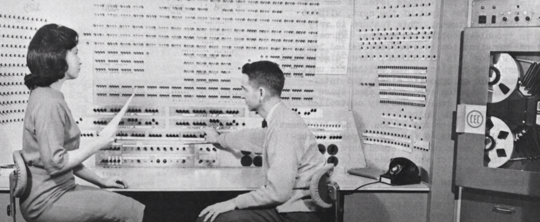 West modeled the Earth’s exact shape based on data from the GEOS satellite. She later became the project manager for SEASAT, which used radar to measure the ocean surface. Her interest led her to work with the IBM 7030 computer to refine models of the Earth known as the geoid. This takes into account things like tidal forces and gravity to compute the true shape of the Earth, rather than simply assuming that it’s a perfect sphere. An accurate geoid is an important part of today’s GPS and similar navigations systems.
Full Ride
Her family did not have the money to send West to school, so she worked hard to earn a full scholarship. The top two graduating high school students got a full ride and through discipline and her intellect, graduated valedictorian in 1948.
She was excellent in all her subjects but elected to major in math. After a brief tenure teaching, she went back for a Master’s degree. Even with an advanced degree, though, teaching didn’t pay very well. Despite her trepidation in moving to Virginia during the 1960s, the Navy job offered her a better wage and she stayed in that job until retirement over four decades later.
Legacy
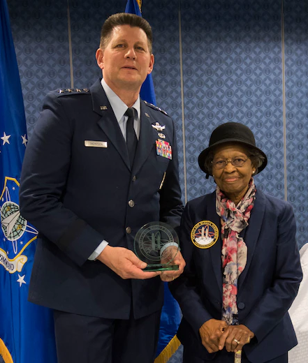 West received several awards during her time at work. In addition, she was inducted into the Air Force Hall of Fame in 2018. The Navy even produced a short video that you can see below.
Of course, many people worked on GPS — known as NAVSTAR at its inception. It wasn’t even the first system of its kind. That honor probably goes to the 1960 Transit project. But all of these systems needed accurate mathematical models of the Earth, and West was a key part of the team that made that happen. Making accurate clocks, keeping them in sync, and shrinking all the components down with a low cost have their own stories and heroes, but for the math, we can thank Gladys West.
We like knowing the stories behind the tech we use every day. We think Gladys West is even more inspiring because of her humble beginnings and the obvious determination and intellect she had to carry her so far. Gladys got her PhD after she retired, but we understand she still prefers to use paper maps.
Want to know more about GPS? We can help. Just want to use it? We’ve come a long way from $3,000 handheld GPS units.


A very intelligent and determined person, I salute her!!
Yes, it’s inspiring to see intelligence and determination can lift a person out of almost insurmountable circumstances.
Intelligence and determination AND a government program can lift a person out of almost insurmountable circumstances.
Damn! Talk about doing something with your life. And a PhD *after* she retired (in Math, I assume)? “Impressive” seems inadequate.
Great story. And you have to credit the military for giving her the opportunity. Whatever else they do wrong, they do offer opportunity to those who might not find it as easily in the civilian world.
If I had any connections still at Virginia Tech, I’d be pestering them about why they haven’t invited her back to speak. She did her PhD here, should be . . . wait, she finished her PhD after retiring in ’98? I was on the wrong side of campus to run into her.
” Even with an advanced degree, though, teaching didn’t pay very well. ”
In a way we have the above to thank for what we have now.
Orbital mechanics have always fascinated me.
I’ve always wondered how the earth was modeled so precisely that it could be used to predict orbits as accurately as they do. I know localized lumps in the gravity can cause the satellites to go a tiny fraction of a degree off course; when extended over a single 126,000 km orbit around the planet that can result in an actual trajectory being a long ways off from the prediction. To get it so accurate that GPS satellites can offer cm precision is just absolutely amazing.
What an achievement! Thank you Mrs. West!
Great story.
Excellent story.
What a great story and a great person!!
Anecdotally, in the late 1990s, I brought a handheld GPS to the Greenwich Observatory and it showed the prime meridian about 75 meters away from where the infamous stripe is painted. (This is the result of differences the GPS data set/ geodetic datum series etc.)
They were not amused.
Given that the prime meridian is THE reference point/line, they should have been amused, that the GPS was so far off!
Possibly because THEY know it’s off an inch or so, for manufacturing reasons and hate to explain the discrepancy
When I went there a few years ago they had a little sign explaining why your GPS doesn’t read 0 on the line at the observatory.
Very nice. Sometime do a related story about the “impossible” Worden Gravity Meter and then the LaCoste-Romberg meter from TI. Both were crucial in gravity mapping by mule and on foot. Accurate local maps are needed for the low altitude stages of any intertially guided flight.
Let’s not forget the other mathematicians who made this breakthrough possible: James South, Anita North, and Cameron East.
I wish I had thought of that!
I wonder if we will have people like this again, the only thing I see for the future is more hatred of scientists and science in this country. People like this are screamed at rather than listened to now.
I wish I was born 90 years ago so I could feel like we progressed somewhere before I died. I’m pretty sure I’m going to just see idiocracy fulfilled as is.
I’ve always been fascinated by gravity mapping and the actual math that they used to do this. It would be interesting if Gladys did a lecture where she summarized her work
I did some work with the GPS/Navstar System in the early 90’s. Seems like the reference frame was the WGS84 datum. undoubtedly the letters were a coincidence, since there was a previous WGS60 and WGS72. Still fun to think she named is West,GladyS ;)
A little boring pre-GPS history: The Navy’s Transit system was for nuclear subs to recalibrate their drifting gyroscopes. Stealth was the priority. Positioning depended on the sub tracking a 15-minute pass of a single satellite overhead, so it needed to stick just its antenna above the water’s surface as the satellite rose above the horizon and retract it as the satellite set. It had to know approximately where it was and where the satellite was to calculate when to stick its antenna up. Also, if another Transit satellite was too close, it would ruin the data from both. So every satellite transmitted its own orbit and information about all the other satellites’ orbits. The sub’s receiver had to sort all that out. The data from the satellite was strong enough to solve for three unknowns, but there were four: The latitude, longitude, and altitude of the antenna’s phase center, and the offset between the receiver’s oscillator and the satelitte’s. The only one of those that could be known beforehand is altitude. But even though the earth is an oblate spheroid, the surface of the ocean isn’t a uniform distance from the geometric center even considering tides. The mean surface varies about 400m from a smooth spheroid. So this had to be mapped. And it was classified: the shape of the earth was classified.