If you look up at the night sky in a dark enough place, with enough patience you’re almost sure to see a satellite cross the sky. It’s pretty cool to think you’re watching light reflect off a hunk of metal zipping around the Earth fast enough to never hit it. Unfortunately, it doesn’t work during the daylight hours, and you really only get to see satellites in low orbits.
Thankfully, there’s a trick that allows you to see satellites any time of day, even the ones in geosynchronous orbits — you just need to look using microwaves. That’s what [Gabe] at [saveitforparts] did with a repurposed portable satellite dish, the kind that people who really don’t like being without their satellite TV programming when they’re away from home buy and quickly sell when they realize that toting a satellite dish around is both expensive and embarrassing. They can be had for a song, and contain pretty much everything needed for satellite comms in one package: a small dish on a motorized altazimuth mount, a low-noise block amplifier (LNB), and a single-board computer that exposes a Linux shell.
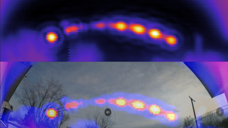
After figuring out how to command the dish to specific coordinates and read the signal strength of the received transponder signals, [Gabe] was able to cobble together a Python program to automate the task. The data from these sweeps of the sky resulted in heat maps that showed a clear arc of geosynchronous satellites across the southern sky. It’s quite similar to something that [Justin] from Thought Emporium did a while back, albeit in a much more compact and portable package. The video below has full details.
[Gabe] also tried turning the dish away from the satellites and seeing what his house looks like bathed in microwaves reflected from the satellite constellation, which worked surprisingly well — well enough that we’ll be trawling the secondary market for one of these dishes; they look like a ton of fun.
Thanks again to [Stephen Walters] for the tip.


HaD price effect incoming! (great read, looking forward to watching the full vid)
Hell, I tried buying one on eBay for one before we ran this post, and still couldn’t find anything reasonably priced.
Seems the real issue is shipping. Gabe tells us he routinely picks these motorized dishes up for $20 or less, but does so locally at flea markets or off Craigslist.
I just spotted on one eBay for $59 with $20 shipping, but you’d have to convince the seller to pop the top and see if there’s a USB A port in there. Cue them wondering why a bunch of people are asking to see pictures of the inside :-)
Quick update on this, if anyone is thinking of doing the same and looking for a compatible antenna:
I got my older (2011) Tailgater with the Mini-USB jack to give me a serial console. The firmware is slightly different and it doesn’t have the elangle command, but everything else seems to be the same. Sadly the motors are 100% seized up from water ingress at some point (probably why I got this one for free). If I can find the same motor online I might try to replace them.
So, I’m guessing any Tailgaters between at least 2011 and 2014 will work for this! You might have to substitute elev for elangle and tweak the range values in the Python code depending on firmware version.
Replace or rebuild.
He’s just so enthusiastic about it. Great project and video.
Would referring to the position as the “equatorial sky” be more accurate for all HAD readers?
How are drones controlled?
Communication links?
And finally, 1960s c/c++ software technology used?
Standard VSAT modem mostly.
C did not exist in the 1960’s, let alone C++
Love it! It strikes me that you can treat the sats as point sources and do a deconvolution of the data to get more detail and smaller points. If you can make it scan in smaller steps it will work even better.
I see you have two of them. Making an interferometer you can get arbitrarily higher resolution based on the spacing between two dishes and do some cool radio astronomy!
I actually have 4, and I’ve actually tried connecting them together in an array (https://youtu.be/dklYG70e7R0). Unfortunately the slightly different phasing and tuning end up making everything noisier. Some people suggested I could do this with a Kraken SDR or 4 separate SDRs and combine the signals somehow, but I have yet to try that.
Yes, phase has to be handled if you want the best method. But I think will work when just using magnitude and your setup. There is something about assumptions of coherence length of the signals that say all your antennas are seeing the same thing and you can do a lot without phase data. I have some books on it and have not looked in decades. With 4 you can do unequal spacing schemes. Or a cruciform. The computations get complicated but they don’t have to be particularly fast. Combinations of methods are possible. Scan a section of sky with stationary disks and use the 4 minutes per degree of Earth rotation. Track or “spotlight” a target. Or a combination of both in order to do a very slow scan and integrate.
It is time consuming to get enough scans to make an image.
Using the Earth’s rotation to scan for GEOSYNCHRONOUS satellites will yield disappointing results. (Not to mention for imaging ground features…)
True enough, but I was on about the cool radio astronomy potential.
Even ignoring the phase if you combine them like that what you get is an intensity interferometer. That isn’t going to give you a signal that varies in a way that allows you to trivially make a sky image like you’ve been doing so far.
It be better to use all 4 at once independently scanning different portions of the sky, then combine their contribution pixels digitally to speed up the imaging cadence.
If you want a more sensitive setup the easiest thing to do is probably to add a shroud around the dish edges to reduce the contributions of off axis noise.