Virginia T. Norwood passed away earlier this year at the age of 96, and NASA’s farewell to this influential pioneer is a worth a read. Virginia was a brilliant physicist and engineer, and among her other accomplishments, we have her to thank for the ongoing success of the Landsat program, which continues to this day.
The goal of the program was to image land from space for the purpose of resource management. Landsat 1 launched with a Multispectral Scanner System (MSS) that Norwood designed to fulfill this task. Multispectral imaging was being done from aircraft at the time, but capturing this data from space — not to mention deciding which wavelengths to capture — and getting it back down to Earth required solving a whole lot of new and difficult problems.
Landsat 1’s payload was overwhelmingly taken up by a more traditional camera system, and so it launched with a stripped-down four-band multispectral imager (down from an original seven) that Norwood and her team shoehorned into the tiny payload allowed for their system. But nothing convinces like results, and the first ones blew people away. Priorities quickly changed; multispectral imaging was here to stay.
Norwood spent most of her career at Hughes, and a bio page at NASA points out that as a woman she faced considerable challenges in her time. There were many otherwise educated men who believed a woman had no place doing technical work, and didn’t think anything of saying so. One male engineer even quit rather than work with a woman. But Norwood wasn’t just technically astute, she was also a skilled communicator able to motivate people to do inspired work.
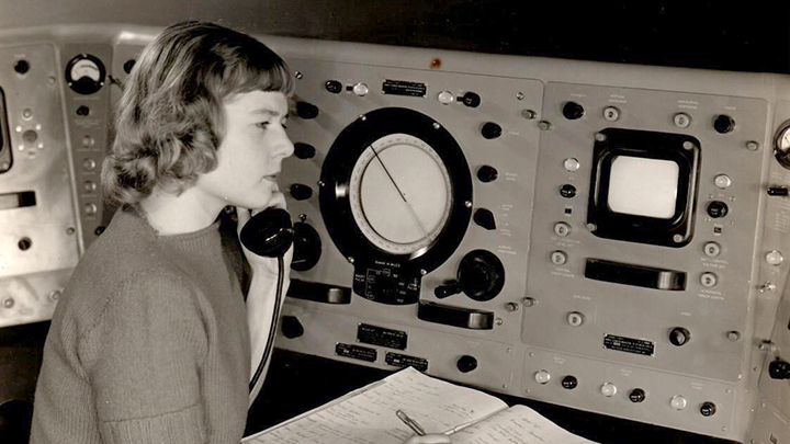
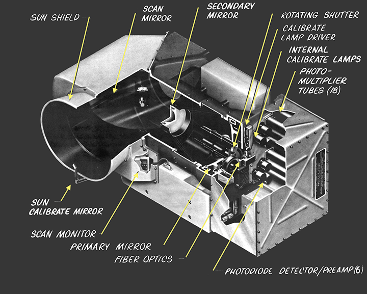
These people skills were important, because the MSS itself — being a new technology — faced uphill challenges compounded by assumptions those in charge had about her and her team’s work. The MSS that launched on Landsat 1 was a scanning digital imager, which built four images (one per band) as a single bit stream that got sent from space to Earth, then got unscrambled back into four separate images. That was pretty new stuff in the late sixties, and even the concept of digital encoding encountered hard resistance. Also, the scanning mirror approach used in the MSS was ultimately described as “groundbreaking”, but before that it was met with heavy derision. Every site visitor commented on the noise the mechanism made, and every time Norwood would remind them that once in the vacuum of space, no one would hear a thing.
Virginia Norwood’s work on Landsat and the MSS are great examples of how physics and math have been applied in transformative ways, and if you’re in the mood for another inspirational example be sure to check out Gladys West, whose work made GPS possible.


this
There wouldn’t be difference. Power has no gender.
… that maybe true, but history has shown that men have been motivated by power far more than woman.
Are you kidding?
Systems of power attract people who are motivated by power.
Historically in URSS, yes. In USA, no.The United States was historically one of the most macho and racist countries in the world.
Does the name Lauren Boebert ring a bell? How about Marjorie Taylor Green? One doesn’t need a Y chromosome to be a self-centered, power hungry fool.
Whoa!
A lot of missing comments here.
Well, I didn’t know (of) her, but it appears that her work is worthy of posting to HackaDay.
There was the thing about maybe Margaret Hamilton didn’t actually write that entire stack of books full of code… I don’t know anything about it, my dad was an Apollo engineer but he wasn’t in charge of computers. Not really important to me.
Norwood is also a powerful meme nowadays
Thanks for that post!
“There were many otherwise educated men who believed a woman had no place doing technical work, and didn’t think anything of saying so. One male engineer even quit rather than work with a woman.”
Even then I would have thought that was stupic… epically stupid.
“Every site visitor commented on the noise the mechanism made, and every time Norwood would remind them that once in the vacuum of space, no one would hear a thing.”
Also it would be pretty far away.
Very interesting article, and (for me) very timely! I’ve been working with a lot of Landsat data recently, and I was a little surprised to hear that people didn’t originally appreciate the need for multispectral imaging. It’s a cornerstone of remote sensing work – just by using the few extra bands on the Landsat Thematic Mapper/Enhanced Thematic Mapper, you can reliably detect and quantify vegetation, or soil moisture, or recently burned forest, to name a few.
The Landsat program has gone on to be such an enormously important and influential resource, and I appreciate learning more about its humble beginnings and the people who fought for it – thank you!
The first Landsat was actually called ERTS1, Earth Technology Satellite). I know because I helped a bit in launching it at Goddard Space Flight Center.