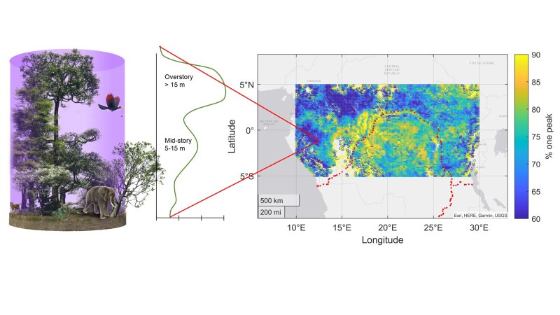
Even though it may seem like we have already explored every single square centimeter of the Earth, there are still many areas that are practically unmapped. These areas include the bottom of the Earth’s oceans, but also the canopy of the planet’s rainforests. Rather having herds of explorers clamber around in the upper reaches of these forests to take measurements, researchers decided to use LiDAR to create a 3D map of these forests (press release).
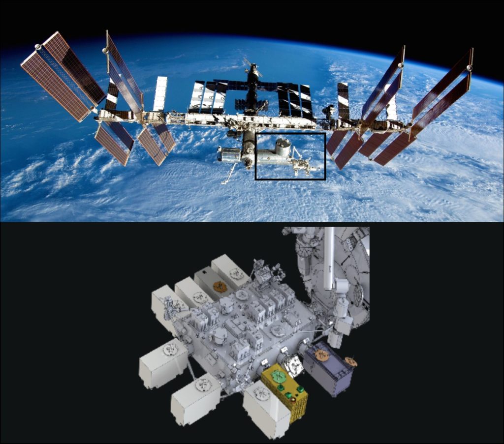
The resulting GEDI (Global Ecosystem Dynamics Investigation) NASA project includes a triple-laser-based LiDAR system that was launched to the International Space Station in late 2018 by CRS-16 where it has fulfilled its two-year mission which began in March of 2019. Included in the parameters recorded this way are surface topography, canopy height metrics, canopy cover metrics and vertical structure metrics.
Originally, the LiDAR scanner was supposed to be decommissioned by stuffing it into the trunk of a Dragon craft before its deorbit, but after NASA found a way to scoot the scanner over to make way for a DOD payload, the project looks to resume scanning the Earth’s forests next year, where it can safely remain until the ISS is deorbited in 2031. Courtesy of the ISS’s continuous orbiting of the Earth, it’ll enable daily monitoring of its rainforests in particular, which gives us invaluable information about the ecosystems they harbor, as well as whether they’re thriving or not.
Hopefully after its hibernation period the orbital LiDAR scanner will be back in action, as the instrument is subjected to quite severe temperature changes in its storage location. Regardless, putting LiDAR scanners in orbit has to be one of those amazing ideas to help us keep track of such simple things as measuring the height of trees and density of foliage.


“Originally, the LiDAR scanner was suppose to be decommissioned by stuffing it into the trunk of a Dragon craft before its deorbit, but after NASA found a way to scoot the scanner over to make way for a DOD payload, the project looks to resume scanning the Earth’s forests next year, where it can safely remain until the ISS is deorbited in 2031. Courtesy of the ISS’s continuous orbiting of the Earth, it’ll enable daily monitoring of its rainforests in particular, which gives us invaluable information about the ecosystems they harbor, as well as whether they’re thriving or not. ”
A good news, after all. While ISS isn’t MIR, it’s still something to remember. Glad to hear it might stay continue to fall up until the 30’s. In an ideal world, it would be kept in graveyard orbit as a symbol and passive instruments platform. Alas, that’s not the case, sadly. In these days we can be glad already if it wasn’t shot. 😂 No, seriously. 😔
ISS is about 250 miles above Earth. It is not far enough to remain in permanent orbit as the atmosphere can shift and expand due to solar wind. Skylab went down permaturely because of unexpected solar flare that expanded the atmosphere and slowed it too much before the space shuttle were ready to grab and move it higher. We don’t want a repeat of Skylab incident with debris littering on land.
So unless someone wants to take over ISS and can move it safely into museum orbit (need big rocket and lots of money), it has to come down in controlled manner with debris ending in the ocean.
I once read there were people on the internet who apparently did the math and found it to be possible to increase the altitude of the ISS. It involved multiple use (boosts) of the transporter crafts, though.
I would say the problem is that it would be extremely vastly massively expensive for no ultimate gain. We humans tend to be sentimental about these kinds of things but with the really limited budgets for space exploration at the moment our science agencies have to target their funds wisely.
Ultimate gain if we don’t have it’s replacement ready.
It’s not only sentimentalism, though.
Symbols can have a powerful effect to people and inspire them. And that’s just priceless.
Let’s just think about the Sphinx, the Great Pyramid of Giza, the Eifel Tower, the Great Chinese Wall, Statue of Liberty, the old Empire State Building. Or 2001 or Star Trek.
These things have influenced people. Their contribution to society was not small. In case of the latter, it caused many break throughs. Simply because it inspired people.
So if we look at it this way, the ISS could be a symbol for peace and friendship. A symbol for co-existance. If after a war, maybe in centuries, people might look through a telescope and see the ancient ISS floating in the skies, they may regain faith in humanity, in what humans can accomplish if they do work together.
Looking it at it this way, the ISS, as a symbol, can be vital for human survival and development. I mean, let’s just look back at how important the first moon landing was to people back then. It left a lasting expression. It even still fascinates people of today, almost 60 years later.
Some of which can’t believe how things were possible with such simple technology. And that’s why books or films of the ISS aren’t sufficient. People must be able to believe, by seeing it witg their own eyes.
Skylab was safeable, maybe. I remember a story about two engineers on ground who were in the process of restoring main power on board Skylab remotely via radio. They issued the power-on command multiple times, with each time the battery charging better/lasting a bit longer (before it powered off again). This was shortly before the mission end was being decided. Skylab’s deorbit was more of a political decision, I assume.
Yea, that ‘Fail Safe Charge’ circuit that they were defeating was an interesting ‘Fail-safe’.. Protect the batteries from being Charged if the Voltage Drops below a Threshold..
Who thought that was a good idea?..
Was this the same crew that later worked on the Landing Gear ‘Touchdown Sensor’ of the Martian Lander.. When the Gear Deployed the Contact Switch ‘Bounced’ it turned off the Decent Rocket thinking it was on the Ground…
Cap
Oh hey I worked with the GEDI people, soldered up a particularly finicky harness for em that’s on station still.
See also LVIS, it’s an endo-atmo airborne system that does similar stuff.
A daily scan of the forests sounds super useful to detect illegal loggimg.
> was supposed to be decommissioned by stuffing it into the trunk of a Dragon
awesome linebreak moment ;)