For those of you rushing to the comment section after reading the title to tell [Ben Dauphinee] that his DIY land surveying efforts are for naught because only a licensed surveyor can create a legally binding property description, relax — he already knows. But what he learned about centimeter-resolution GPS is pretty interesting, especially for owners of large rural properties like him.
[Ben]’s mapping needs are less rigorous than an official survey; he just wants to get the locations of features like streams and wood lines, and to get topographic elevations so that he has a general “lay of the land” for planning purposes. He originally engaged a surveyor for that job, but after shelling out $4,600 to locate a single property line, he decided to see what else could be done. Luckily, real-time kinematics, or RTK, holds the key. RTK uses a fixed GPS station to provide correction signals to a mobile receiver, called a rover. If the fixed station’s position is referenced to some monument of known position, the rover’s position can be placed on a map to within a couple of centimeters.
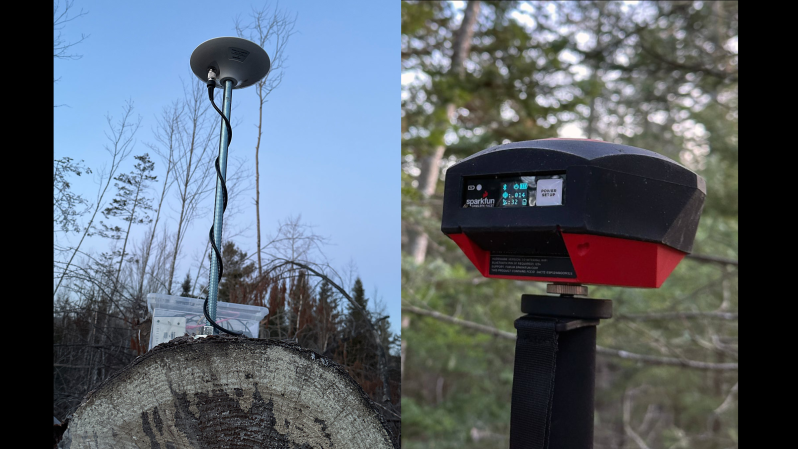
To build his own RTK system, [Ben] used some modules from SparkFun. The fixed station has an RTK breakout board and a multi-band GNSS antenna to receive positioning data, along with a Raspberry Pi to run the RTK server. An old iPhone with a prepaid SIM provides backhaul to connect to the network that provides correction data. [Ben]’s rover setup also came mainly from SparkFun, with an RTK Facet receiver mounted on a photographer’s monopod. Once everything was set up and properly calibrated, he was able to walk his property with the rover and measure locations to within 4 centimeters.
This was not an inexpensive endeavor — all told, [Ben] spent about $2,000 on the setup. That’s a lot, especially on top of what he already paid for the legal survey, but still a fraction of what it would have cost to have a surveyor do it, or to buy actual surveyor’s equipment. The post has a ton of detail that’s worth reading for anyone interested in the process of mapping and GPS augmentation.


i am currious, why not use the data from us, eu and chinese gps? They all together should pretty exact. Also the cheapest smartphones are able to get all signals.
Because gps signals are not that accurate. Not down to the centimeter range. You need a fixed location offset to “correct” the GPS signal.
Thanks David!
I did the math, crap*crap=crap
That’s only true for certain values of crap
You are correct. Two values.
Solve for x:
x² = x
0, 1
you really should rms your crap: sqrt(crap*crap)
I have taught myself to use a theodilite and have
a couple of honest to goodness surveyors chains,
as the long steel tapes are called.The math is simple,just angles and distances and area calculations,same deal,wanted to choose where
subdivision lines would fall,in order to include features and calculate set backs for projects,
measure out land blocks and fields,and of course
non of it is legal,but the work is done and then just
paying for posts is easy,dont have to explain anything,pointing is all.
“Theodolite”
I think it’s very pleasing to use a Theodelight.
Even more pleasing for Theo!
B^)
A possible solution if you live on a plain, but a terrible option when you live in a mountainous terrain full of trees.
Funny you should mention, that land is on the mountain with trees. I’m about 110M elevation, sloping to about 90M at the front, and most of my land is forest. I’m thankful there’s a clearing for me to mount the antenna, otherwise I would have had to drop it roadside or somewhere further away from my property.
Problem with using a Chain (tape measure) is you will need two people. If distance is greater than the Chain, then you will need to “break chain”, especially if going uphill.
“Total Stations” (EDM, Electronic Distance Measurement) instruments are relatively cheap on eBay. They also measure horizontal & Vertical Angle. And will correct Slope Distance to Horizontal. Depending on the Reflector used can go out to several thousand feet. (Even a 4” Road Reflector can suffice). I got one for $500. Also, cheap handheld 100 yd Laser EDM’s are about $100. (Bosch)
Lots of free CoGo (Coordinate Geometry software) is available.
I don’t understand why it takes two for taping, though it does make it easier. I use a 300 ft fiberglass tape graduated in tenths, that does not shrink or grow. A total station is nice, but for hobby/home use a theodolite will do, as there are methods to solve the issues you have mentioned, and one needs to learn the basics anyway. A good text, such as John C Tracy’s “Plane Surveying” will teach all the mechanics of land surveying.
If you really want some good instructional work on non-GPS surveying, I highly recommend “plane surveying” by John C Tracy, which can be downloaded for free. it’s a college-level book written in 1912 but all the principles apply today. It covers all aspects of rural and city land surveying, and will explain how surveyors get within 0.5″ using tapes and transits, along with finding your position on earth by the sun and stars.
“But what he learned about centimeter-resolution GPS is pretty interesting, especially for owners of large rural properties like him.”
Autonomous farms. BEGIN!
Already here, agOpenGPS.
What Ben did is called a “Detail Survey”. When I was surveying it was one of the cushier jobs you could get. One setup, and then wander around all day marking tops and toes of banks, infrastructure, sizeable trees and the occasional spot height.
As someone who has a future task of doing a “detail survey” of a large rural property, how do you correlate a GPS reading with the actual location of interest?
Notes, lots of notes. Either recorded on the device as you take each shot, or in a notebook along with the number of that shot so you can match them up later
Drones are the way to go these days. I deal mainly in roof surveys for solar project, commercial sized. We get sub inch relative accuracy when using RTK on the drone in conjunction with ground control points.
What Dan M said, but in addition you positively locate a reference point for your initial setup, then all your subsequent shots can be related to that. For a domestic property we would typically use a permanent survey mark or similar, but for a large rural property or, say, a mining lease, you put in a set of control points that you can later use for other purposes.
Huh. I was going to try this a couple decades ago and several “experts” told me the error in two nearby receivers are not correlated. Given the costs back then I put it on the far back left burner.
Now I have to study this!
I have a Garmin on my dashboard which at times has a wild imagination.
Like the time it showed me driving 100 meters below Sea Level, or the time it reported I was driving 138 mph across a plowed field (like my Honda CR-V even go that fast on pavement!).
Interface it to the CAN BUS to ensure that the car door windows are automatically closed.
Just in case. Better safe than sorry.
And of course to the most stupid of most stupid inventions. That “I’m stupid” button on the truck hatch door that car owners press so that they don’t have to pull the door down.
Press the “I’m stupid” button. vs. Pull the hatch closed. It’s a small step for man. But a giant step for mankind.
Don’t want water sneaking in from you rear end. :)
Miss my Nokia/Microsoft Lumia 535 with a simple windows store map app, it was the best gps i ever used.
And the homebrew 6Tin App for Tinder from Rudy Huyn, was unbelivable good. You could locate yourself everywhere on the planet and got matched before your bussines trips. Tinderphone you will never got forgotten.
Google lead me serveral times into the wrong traffic at night.
The correlation between calculated position of two receivers is quite poor, they might even receive different set of satellites. You need a setup where each receiver reports individual satellite readings and then software to calculate the corrected position.
Good idea. Also, give priority to overhead satellites. But maybe Ublox correction data algo already does all this stuff.
I’m a Geomatics Engineer and I work for a high precision GNSS receiver manufacturer, and I also just finished a graduate class in GNSS receiver design. The long and short of it is, many errors are correlated up to a separation of 60km or so, but many others are not. Setting up a receiver on a known point, and broadcasting the difference between the measured location and known location is valid. But getting closer doesn’t actually reduce the error until you’re within like 20cm
Nice job! I am a Licensed Land Surveyor in 3 States and my only caution here would be “the answer rarely lies in the math..”. Junior and Senior rights often play a notable role in boundary surveying and coordinates are only as good as the users ability to understand their precision. In fact coordinates fall to the bottom of all lists when it comes to the order of importance for controlling elements of a boundary survey.
This is a great system to “poke around with” if you have known data provided to you from a professional surveyor. Just remember, if you wanted to survey your own property from scratch, you could end up defending those actions against a licensed professional’s opinion in court and that will not be fun!
Just because you know where a couple of iron pins are, doesn’t mean they are actually in the right place. The subject property description along with the adjoining properties description in title must correspond correctly with the evidence found on the ground, otherwise it means nothing. Beware…
Found one!
For those of you rushing to the comment section after reading the title to tell [Ben Dauphinee] that his DIY land surveying efforts are for naught because only a licensed surveyor can create a legally binding property description, relax
If you don’t have a known precise location, you can gather data from your RTK base station for 24 hours and submit it to https://webapp.csrs-scrs.nrcan-rncan.gc.ca/geod/tools-outils/ppp.php and they will send you the coordinates accurate to 1.4cm
…. or do it for a whole week to get down to mms.
Great info Michael, however you don’t necessarily need a 24 static session to get centimeter level accuracy. With dual frequency GNSS, I have achieved sub-centimeter (horizontal) accuracy with 5-6 hours of observations at 1 second intervals in remote areas of Western Canada. This is highly useful where the nearest monument might be outside your RTK range. However vertical accuracy is generally half as accurate, so obviously the longer your session, the better.
Wrote a paper on the topic of “3D GIS” that included RTK that overlayed the mathematical elements in their order of importance for control of a boundary survey to defend those rights that would be argued in court by a licenses professional surveyor. Thereby combining the two systems of coordinates and boundary surveys one could easily defend any actions brought up in any court of law. I stand respectfully with surveying methods as they are the foundation to precision. By combining both worlds of location makes it a necessary complement to each other’s functionality strong points when it comes down the efficiency of gathering location data.
In kind spirit.
Where can I see a copy of this paper?
Another source of hardware is https://www.navspark.com.tw.
another interesting starting point for hobby level stuff : https://www.ardusimple.com/rtk-starter-kits/
(never tried it – I repair survey grade RTK for a living so get to borrow it for free when I want to mess around)
This worked for me, real time corrections from local Dept of Transportation via wifi, ground plant from the bottom of a or tin, and I got to eat the pie. Its not $2000, its $200
I would like to know if I can submit my rough floor plan and draft elevation sketches to the local council for my proposed build rather than pay ridiculous prices to a professional architect to do similar with CAD?
Depends on the local council. You should be able to review past approved permits in your immediate area, probably online. I got a permit and then built a completely different house. For my area, it didn’t matter as long as all of the rules were still met (setback, septic, elevation, etc.).
Progress. I’m amazed an many of the projects here. So many clever people, doing clever things. And the great advise from others in the comments. I’m so happy to see so many open source projects making a difference. I should get involved.
On a lighter note: In the old days, John Chisum (embodied wonderfully in Film by John Wayne) only needed a couple of wooden posts and a shotgun to determine the boundaries of his land.
Cost? Nothing. Would you want to argue with John Wayne’s shotgun? Me neither.
What about his horse?
No. Not scared. Hoof is to big to pull the trigger.
Ridiculous.
I’m a PSM/PLS. My Emlid RS3 was $2700 new
Uses GNSS on NCGS network $500.
You need no base. IMU Tilt allows non plumb rod shots up to 30 degrees .
Software comes from Emlid
$3200 for REAL gear
JTG
3200 CAD or USD? This setup was roughly $2k CAD, and still at least a grand less than “real” gear. An IMU would be a great addition to my gear, but lacking that, a pole attached level seems to have served my needs well enough 😁
And if you had read the article, you may have spotted that there are correction source networks here, but no base station close enough to my location for the accuracy I wanted.
Plus friend, don’t sneer at a fun project, because at the end of the day, this was fun to learn how to do.
How accurate can you get with just using one of those apps that averages out the GPS signal in 10 minutes?
Not very precise, because of systematic errors, most notably ionosphere. GPS position is based on difference in time of arrival between the satellite signals. In principle, this time difference translates to a distance difference, the factor being the speed of light. However, in the ionosphere, the (local) speed of light is determined by the density of free electrons flying around, and this changes according to solar activity. Ergo, travel time changes and everything is wrong. This effect is systematic for satellites in a certain direction, so waiting for 10 minutes will not have strong impact. Taking into account ionosphere, e.g. by receiving info about the ionosphere from an SBAS satellite, or by obtaining it online, reduces the error to about half a meter (2 feet).
It’s illegal to survey without proper accreditation. You can do your own surgery too.
I am a licensed land surveyor. It is not illegal to “survey” within the boundaries of your own property. However, State law usually requires monuments that are set to mark the corners of legal property boundaries to be set by a state licensed land surveyor in accordance with state law and the same to be recorded in the appropriate state, county, borough, or parish recorders office.
The science of surveying, including the science behind the Global Navigation Satellite System (GNSS), can be fun. The art of boundary surveying is knowing what controls your boundary and the legal principles for defending your decisions in a court of law.
As stated earlier in this thread, there can be legal and monetary consequences for setting boundary monuments without the proper state licensing.
So use your GPS equipment to do all types of fun and interesting projects on your property, just be careful about setting any “markers” that can be relied upon by an innocent third-party.
+1 For the same reason why official authenticated USGS aerial images are better in court than a DIY drone survey made by your kid. Also, professional survey property points are great for accurate referencing your personal surveys.
I actually do my own surgery ….. it’s quite fun !!!
> For those of you rushing to the comment section after reading the title to tell [Ben Dauphinee] that his DIY land surveying efforts are for naught because only a licensed surveyor can create a legally binding property description, relax — he already knows.
Interesting article. I had a job over the summer to gather data and design a network for fiber optic. My boss and I tried to get equipment sent to us by our company it never showed up. We only used our phones to make kmz files on Google earth. I hoped to find cheap off the shelf equipment that I could expense to the company. I bought a device from a sports store. $150. Had to go through 5 loops and hoops to transfer one way point to my computer!?!?
GPS signals drift because of ionospheric storms. We use ground based stations called pseudo-lights to measure and correct GPS data before it can be trusted on a plane. This is the Wide Area Augmentation system which sends the correction signals to a geostationary satellite. Your principles are the same but managed at a lower scale. The drift is compensated by your stationary receiver/transmitter. Good project.
Confused on why you are trying to get cm accuracy on your land if it’s for planning a here position is perfectly fine in fact I used to use 5000, 5000 and 1000 Elevation and processed static receivers for the coordinates and a base set up you usually process the PPP after all said and done and all you need is a local system for your place and on another note you shelled out 4600 did you shop around and ask who normally worked in that area I’m pipeline and wellsite surveyor and we aren’t the ones to call for these type of jobs more expensive and of you really want the lay of the land pay for lidar if it’s a big area
To point 1, I wanted cm accuracy because I’m a giant nerd, and also I disliked that the first survey I did had as much inaccuracy as it did. I have some small brooks that twist back and forth in spots, and I wanted to be accurately plot them, so I only have to do it once, as an example. There are a lot of other things, like trees, that I want to survey and tag as well. Also, once I buy the gear, I own it and can do as much as I want without further cost.
To point 2, there’s not a lot of shopping around in this area. The closest surveyor is a 20 min highway drive from here, and they’re the ones that had the files for this area already. All told, it was shots to establish my boundary from control points that were several km away from my location, and a some time on the land with a 2 man crew to actually blaze the line in the woods.