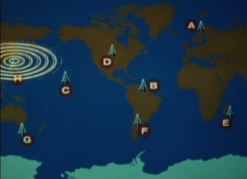
In 1971, the United States Navy launched the Omega navigational system for submarines and surface ships. The system used radio frequencies and phase difference calculations to determine global position. A network of eight (VLF) transmitter sites spread around the globe made up the system, which required the cooperation of six other nations.
Omega’s fix accuracy was somewhere between one and two nautical miles. Her eight transmitter stations were positioned around the Earth such that any single point on the planet could receive a usable signal from at least five stations. All of the transmitters were synchronized to a Cesium clock and emitted signals on a time-shared schedule.
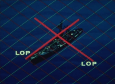 A ship’s receiving equipment performed navigation by comparing the phase difference between detected signals. This calculation was based around “lanes” that served to divvy up the distance between stations into equal divisions. A grid of these lanes formed by eight stations’ worth of overlapping signals provides intersecting lines of position (LOP) that give the sailor his fix.
In order for the lane numbers to have meaning, the sailor has to dial in his starting lane number in port based on the maps. He would then select the pair of stations nearest him, which were designated with the letters A to H. He would consult the skywave correction tables and make small adjustments for atmospheric conditions and other variances. Finally, he would set his lane number manually and set sail.
Thanks for the tip, [MicroGadgetHacker]!
Retrotechtacular is a weekly column featuring hacks, technology, and kitsch from ages of yore. Help keep it fresh by sending in your ideas for future installments.


and down it comes:
https://www.youtube.com/watch?v=qNi75OWgzkw
That is just incredible. It looked like it could have hit so many buildings just because of it’s massive size and they did it in the direction away from them AND made it fold over on itself to reduce the damaged area.
Here is an article about the one in Australia coming down in April 2015. The videos look pretty similar, the tower buckles in almost the same way after the explosion.
http://www.abc.net.au/news/2015-04-22/omega-tower-australias-tallest-man-made-structure-demolished/6412100
What do they use today? Not like GPS works 800 feet down,
Not a ton of detail here, but its a start: https://en.wikipedia.org/wiki/Submarine_navigation
Omega was also used in air navigation. I once owned an aircraft (C210F) equipped with an Omega navigation receiver. I remember it because it had the least intuitive panel of any device I have ever used. Even with the summary instruction card I could never use it and fly the plane at the same time. A very senior instructor I had could occasionally get it to point us in the right direction: I think he liked the challenge. Luckily a very primative GPS unit was more helpful, even with a very out-of-date database. I eventually replaced the Omega receiver, but still have it in a box somewhere. The 5×5 (?) array of buttons with obscure abbreviations that contolled unprompted menues multiple layers deep still remindes me how far user interfaces have come.
stike this…. it was a LORAN receiver, not OMEGA!!!